Filey regional road map. Full 60 × 60 km PDF, SVG and Illustrator files, with a free PDF sample.

GBMAPS.COM

Filey Regional Road Map

Call Us Now for Help01751 473136

GREAT BRITAIN ROAD ATLAS · 1:250,000 RY-54

Filey & surrounding area

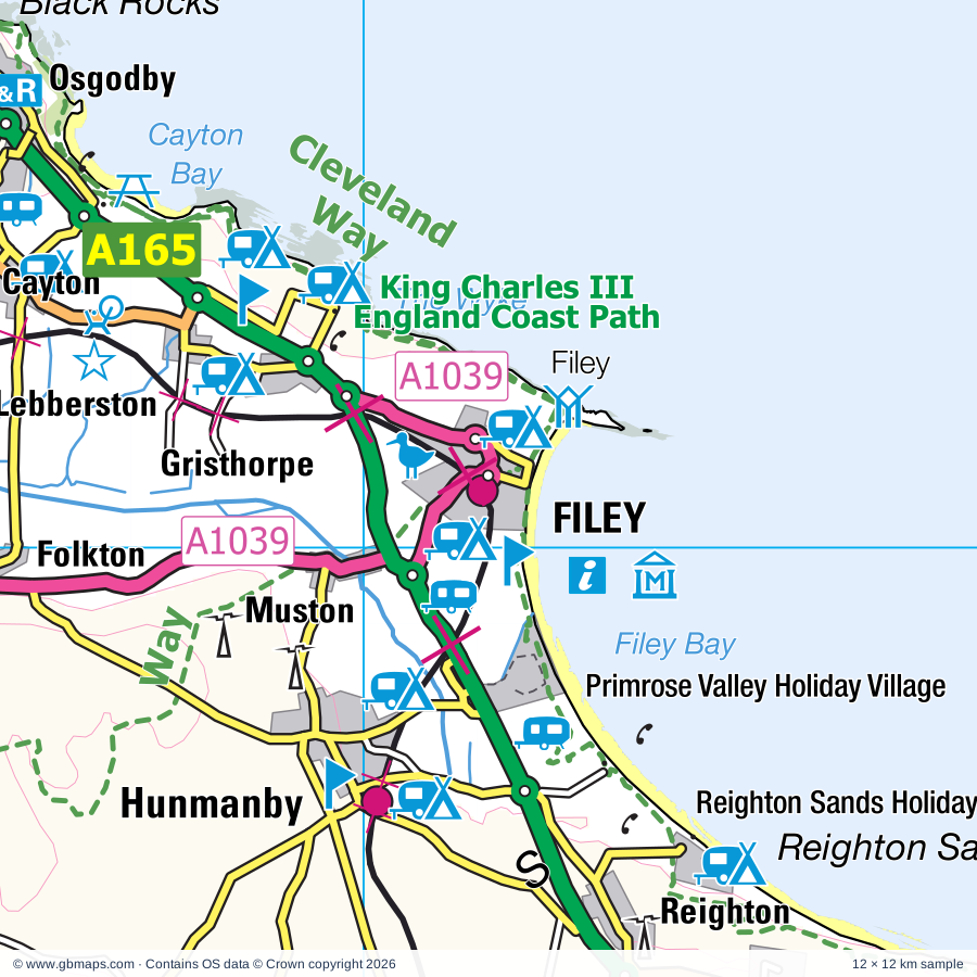
Explore the full 60 × 60 km Filey regional road map at 1:250,000, covering Filey, Scarborough, Bridlington, Driffield, Pickering. Compare the complete coverage below; a detailed PDF sample is available free.

FILEY & SURROUNDING AREAREGIONAL ROAD MAP
60 × 60 km · Full map previewDownload the free SVG ↓

INSIDE THE FULL 60 × 60 KM MAP

Explore the Filey map area

1:250,000 cartography

Towns, villages & places

More mapped places (108)
  • Thwing
  • Foxholes
  • Ganton
  • East Ayton
  • Bempton
  • West Ayton
  • Boynton
  • Rudston
  • Scalby
  • Wykeham
  • Butterwick
  • Sherburn
  • Sewerby
  • Everley
  • Burniston
  • Suffield
  • Haisthorpe
  • Flamborough
  • Kilham
  • Weaverthorpe
  • Carnaby
  • Langtoft
  • Thornholme
  • Sawdon
  • Burton Agnes
  • Hackness
  • Cloughton
  • Helperthorpe
  • East Heslerton
  • Silpho
  • Snainton
  • Harpham
  • Ruston Parva
  • East Lutton
  • Fraisthorpe
  • Broxa
  • Lowthorpe
  • Ebberston
  • Gransmoor
  • Yedingham
  • Harwood Dale
  • Staintondale
  • Nafferton
  • Barmston
  • Great Kelk
  • East Knapton
  • Allerston
  • Lissett
  • Wintringham
  • Sledmere
  • Gembling
  • Kirby Grindalythe
  • Wansford
  • Little Driffield
  • Elmswell
  • Wilton
  • Ulrome
  • Scampston
  • Ravenscar
  • Kelleythorpe
  • Rillington
  • Skerne
  • Duggleby
  • Dringhoe
  • Skipsea
  • Beeford
  • Brigham
  • Eastburn
  • Wetwang
  • Thornton-le-Dale
  • Kirkburn
  • Scagglethorpe
  • Lockton
  • Dunnington
  • Southburn
  • Fimber
  • Settrington
  • Tibthorpe
  • Low Marishes
  • Rotsea
  • Wykeham
  • Levisham
  • Robin Hood's Bay
  • Fylingthorpe
  • Hempholme
  • Raw
  • Bewholme
  • Atwick
  • Fridaythorpe
  • Bainton
  • Birdsall
  • Thixendale
  • North Dalton
  • Sneaton Thorpe
  • Hawsker
  • Huggate
  • Littlebeck
  • Stainsacre
  • Goathland
  • Sneaton
  • Ugglebarnby
  • Beck Hole
  • Sleights
  • Grosmont
  • Aislaby
  • Warter
  • Millington
  • Egton

Roads across this sheet

A64, A164, A165, A166, A169, A170, A171, A614, A1038, A1039, B1229, B1242, B1246, B1248, B1249, B1251, B1252, B1253, B1254, B1255, B1257, B1258, B1259, B1261

More road numbers

B1364, B1410, B1415, B1416, B1427, B1447

Rivers & waterways

Costa Beck, Driffield Canal, Frodingham Beck, Gypsey Race, Kelk Beck, Old Howe, River Derwent, River Esk, River Hertford, River Hull, River Rye, Thornton Beck

Landmarks & landscape

Bayle Gate Museum, Beck Hole, Bempton Cliffs Nature Reserve, Bempton Cliffs Visitor Centre, Boggle Hole, Bondville Model Village, Bridestones Nature Reserve, Burton Agnes Hall, Burton Agnes Hall Garden, Clarence Gardens, Dalby Forest Drive, Deerholme Pottery, NORTH YORK MOORS NATIONAL PARK

More named features

Duggleby Howe, Ebberston Hall, Esk Leisure, Falling Foss, Filey Country Park, Filey Dams Nature Reserve, Filey Folk Museum, Forge Valley Woods, Go Ape Dalby, Hunt House, John Bull Confectioners, Kinderland, Langdale Quest, Levisham Moor, Lilla Cross, Luna Park, Mallyan Spout, Millington Wood Nature Reserve, North Sands Nature Reserve, North Yorkshire Moors Railway, North Yorkshire Motor Museum, Northstead Manor Gardens, Old Coastguard Station, Old Coastguard Station Visitor Centre, Old Penny Memories, Park Rose Leisure Park, Park Rose Owl Sanctuary, Peasholm Park, Pickering Castle, Playdale Farm Park, Robin Hood's Bay Museum, Music in Miniature Exhibition, Rotunda Museum, Old Mill Toy Museum and Tea Rooms, Wood End Museum, Rudston Monolith, Scampston Hall, Scampston Hall and Gardens, Scarborough Art Gallery, Central Tramway Cliff Lift, Scarborough Castle, Scarborough Millennium Heritage Centre, Anne Bronte's Grave, Terror Tower, Sea Life Centre, Sewerby Hall, Sewerby Hall Gardens, Skipsea Castle, Sledmere House, South Cliff Gardens, Holbeck Gardens, Stained Glass Centre, Staitondale Shire Horse Farm, The Betton Farm Visitor Centre, The Grainary Wildlife Farm, The Mere, Trailways Visitor Centre, Wharram Percy Deserted Medieval Village, Wharram Percy Village, Wheeldale Roman Road, Willy Howe, Wykeham Lakes
Local authority & parish coverage

Wholly or partly within the full map rectangle. These boundaries are coverage information, not additional artwork layers.

  • East Riding of YorkshirePartly within
  • North YorkshirePartly within
Wards & electoral divisions 33 areas
  • Beverley Rural Ward (part)
  • Bridlington Central and Old Town Ward
  • Bridlington North Ward
  • Bridlington South Ward
  • Driffield and Rural Ward
  • East Wolds and Coastal Ward (part)
  • North Holderness Ward (part)
  • Pocklington Provincial Ward (part)
  • Wolds Weighton Ward (part)
  • Amotherby & Ampleforth ED (part)
  • Castle ED
  • Cayton ED
  • Danby & Mulgrave ED (part)
  • Derwent Valley & Moor ED
  • Eastfield ED
  • Esk Valley & Coast ED (part)
  • Falsgrave & Stepney ED
  • Filey ED
  • Hunmanby & Sherburn ED
  • Kirkbymoorside & Dales ED (part)
  • Malton ED (part)
  • Newby ED
  • Northstead ED
  • Norton ED (part)
  • Pickering ED (part)
  • Scalby & the Coast ED
  • Seamer ED
  • Sheriff Hutton & Derwent ED (part)
  • Thornton Dale & Wolds ED (part)
  • Weaponness & Ramshill ED
  • Whitby Streonshalh ED (part)
  • Whitby West ED (part)
  • Woodlands ED
Civil parishes & communities 127 areas
  • Acklam CP (part)
  • Aislaby CP
  • Allerston CP
  • Atwick CP (part)
  • Bainton CP
  • Barmston CP
  • Beeford CP
  • Bempton CP
  • Beswick CP (part)
  • Bewholme CP (part)
  • Birdsall CP (part)
  • Bishop Wilton CP (part)
  • Boynton CP
  • Brandesburton CP (part)
  • Bridlington CP
  • Brompton CP
  • Broxa-cum-Troutsdale CP
  • Burniston CP
  • Burton Agnes CP
  • Burton Fleming CP
  • Burythorpe CP (part)
  • Carnaby CP
  • Cayton CP
  • Cloughton CP
  • Cottam CP
  • Darncombe-cum-Langdale End CP
  • Driffield CP
  • Duggleby CP
  • East Ayton CP
  • Eastfield CP
  • Ebberston and Yedingham CP
  • Egton CP (part)
  • Eskdaleside cum Ugglebarnby CP
  • Filey CP
  • Fimber CP
  • Flamborough CP
  • Folkton CP
  • Foston CP
  • Foxholes CP
  • Fridaythorpe CP
  • Fylingdales CP
  • Fylingdales and Hawsker-cum-Stainsacre CP
  • Ganton CP
  • Garton CP
  • Goathland CP
  • Grindale CP
  • Gristhorpe CP
  • Grosmont CP
  • Habton CP (part)
  • Hackness CP
  • Harpham CP
  • Harwood Dale CP
  • Hawsker-cum-Stainsacre CP (part)
  • Heslerton CP
  • Hornsea CP (part)
  • Huggate CP
  • Hunmanby CP
  • Hutton Buscel CP
  • Hutton Cranswick CP
  • Hutton Mulgrave CP (part)
  • Irton CP
  • Kelk CP
  • Kilham CP
  • Kirby Grindalythe CP
  • Kirby Underdale CP (part)
  • Kirkburn CP
  • Langtoft CP
  • Langton CP (part)
  • Leavening CP (part)
  • Lebberston CP
  • Levisham CP
  • Lockton CP
  • Luttons CP
  • Malton CP (part)
  • Marishes CP (part)
  • Middleton CP (part)
  • Millington CP
  • Muston CP
  • Nafferton CP
  • Newby and Scalby CP
  • Newholm-cum-Dunsley CP (part)
  • Newton CP (part)
  • North Dalton CP (part)
  • North Frodingham CP
  • Norton-on-Derwent CP (part)
  • Nunburnholme CP (part)
  • Osgodby CP
  • Pickering CP (part)
  • Pocklington CP (part)
  • Reighton CP
  • Rillington CP
  • Rudston CP
  • Scagglethorpe CP
  • Scampston CP
  • Scarborough CP
  • Seamer CP
  • Settrington CP
  • Sherburn CP
  • Silpho CP
  • Skerne and Wansford CP
  • Skipsea CP
  • Sledmere CP
  • Snainton CP
  • Sneaton CP
  • Staintondale CP
  • Stape CP (part)
  • Suffield-cum-Everley CP
  • Thixendale CP (part)
  • Thornton-le-Dale CP
  • Thorpe Bassett CP
  • Thwing CP
  • Tibthorpe CP
  • Ugthorpe CP (part)
  • Ulrome CP
  • Warter CP (part)
  • Watton CP (part)
  • Weaverthorpe CP
  • West Ayton CP
  • Wetwang CP
  • Wharram CP
  • Whitby CP (part)
  • Willerby CP
  • Wilton CP
  • Wintringham CP
  • Wold Newton CP
  • Wykeham CP
  • Yapham CP (part)

Source: the GBMaps road atlas, OS Boundary-Line and postcode mapping datasets. Source editions are being checked for publication. Unmarked boundary names are wholly within the sheet; “part” means the map edge crosses the area.

Place lists are selected from the map source, not a complete gazetteer. Named features describe the cartography; visitor facilities and opening status are not verified. The free sample covers only 12 × 12 km of this larger sheet.

INSIDE YOUR DOWNLOAD

A proper road map, in useful formats

Road classifications, towns and villages, railways, rivers, landscape detail and tourist symbols, brought together in the GBMaps regional road atlas style.

PDF filePDFSVG fileSVGAdobe Illustrator AI fileAi

PDF for the finished map. SVG and layered Illustrator artwork for adapting colours, adding your own information and preparing designs.

THE FINISHED SHEET

Designed for print and presentation

Map coverage
60 × 60 km
Sample coverage
12 × 12 km
Print layout
A3 landscape · enlarged 1:250k cartography
Sheet furniture
Border, scale bar, key & north arrow

A few useful details

What changes when I select another square?

Select a surrounding square to bring it into the centre and reveal the maps around it. Each square is a different 60 × 60 km map. The preview, free sample and selected download change together. Neighbouring sheets overlap by 30 km so you can choose the coverage that suits you.

Is the free sample a vector map?

The on-page detail is an SVG. The free download is a separate 12 × 12 km PDF with a link to the full map. Please retain its copyright credits and product link when sharing it.

Can I buy a larger combined map?

These downloads are individual ready-made sheets. Contact GBMaps if you need a larger combined area.

FREE PDF SAMPLE

Your free map sample

Your free 12 × 12 km sample includes a link back to this map, so you can return for the full area whenever you need it.

Download free PDF sample ↓

Get your Filey map

Map download bundle

£24.00including VATOne payment

Pay securely

One payment. Your map stays open.

Your map download

Your map files

Preparing your download…

Checking your private download link…

Your map downloads

Already bought a map?

Find the downloads from your purchases.

Enter the email address you used at checkout. We’ll email you a private link to your available map downloads.