Fasnacloich regional road map. Full 60 × 60 km PDF, SVG and Illustrator files, with a free PDF sample.

GBMAPS.COM

Fasnacloich Regional Road Map

Call Us Now for Help01751 473136

GREAT BRITAIN ROAD ATLAS · 1:250,000 GB-210-0750

Fasnacloich & surrounding area

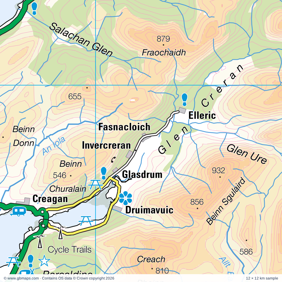
Explore the full 60 × 60 km Fasnacloich regional road map at 1:250,000, covering Fasnacloich, Ballachulish, Glencoe, Caolasnacon, Duror. Compare the complete coverage below; a detailed PDF sample is available free.

FASNACLOICH & SURROUNDING AREAREGIONAL ROAD MAP
60 × 60 km · Full map previewDownload the free SVG ↓

INSIDE THE FULL 60 × 60 KM MAP

Explore the Fasnacloich map area

1:250,000 cartography

Towns, villages & places

  • Fasnacloich
  • Ballachulish
  • Glencoe
  • Caolasnacon
  • Duror
  • Kentallen
  • Creagan
  • Onich
  • Kinlochleven
  • Kinlochmore
  • Inchree
  • Corran
  • Clovullin
  • Barcaldine
  • Appin
  • Portnacroish
  • Bonawe
  • Blarmachfoldach
More mapped places (38)
  • North Shian
  • Port Appin
  • Aryhoulan
  • Taynuilt
  • Bridge of Orchy
  • Stronmilchan
  • Benderloch
  • Ledaig
  • Black Crofts
  • Lochawe
  • Trislaig
  • Clachan
  • Connel
  • Camusnagaul
  • Achaphubuil
  • Caol
  • Achnacroish
  • Corpach
  • Banavie
  • Dunbeg
  • Torlundy
  • Blaich
  • Kilchrenan
  • Cladich
  • Annat
  • Duisky
  • Torcastle
  • Fassfern
  • Ganavan
  • Clifton
  • Coillaig
  • Tyndrum
  • Strontian
  • Kinlocheil
  • Kilmore
  • Crianlarich
  • Fersit
  • Kilninver

Roads across this sheet

A816, A819, A861, A884, B840, B844, B845, B863, B8004, B8006, B8043, B8045, B8074, B8077

Rivers & waterways

Abhainn Cam Linne, Abhainn Dalach, Abhainn Rath, Abhainn Shira, Allt Braglenmore, Allt Coire a Chaolain, Allt Coire an Eoin, Allt Dochard, Allt Easach, Allt Fearna, Allt Feith Thuill, Allt Fionn Ghlinne

More waterways

Allt Hallater, Allt Kinglass, Allt Laire, Allt Loraich, Allt Mhoille, Allt Tolaghan, Allt a' Choromaig, Allt an Stacain, Allt na Caim, Allt na Lairige, Allt na Lairige Moire, An Iola, An t-Suileag, Black Water, Caledonian Canal, Callop River, Ciaran Water, Cladich River, Cona River, Dearg Abhainn, Dubh Eas, Dubh Lighe, Eas a' Ghaill, Feochan Bheag, Fionn Lighe, Lusragan Burn, River Awe, River Ba, River Coe, River Cononish, River Coupall, River Esragan, River Etive, River Euchar, River Falloch, River Fyne, River Gour, River Hurich, River Kiachnish, River Kinglass, River Leven, River Lochy, River Moidart, River Nevis, River Orchy, River Scaddle, River Spean, River Strae, River Tarbert, Strontian River, Teatle Water, The Cour, Water of Nevis, Water of Tulla

Landmarks & landscape

Achnacloich Garden, An Steall (Waterfall), Angus's Garden, Appin House, Ardanaiseig Gardens, Ardchatton Garden, Ardchatton Priory, Ardentallen House, Argyll Pottery, Barcaldine Castle, Ben Nevis Distillery, Black Corrie Lodge, LOCH LOMOND & THE TROSSACHS NATIONAL PARK

More named features

Bonawe Iron Furnace, Bridge of Orchy Bunkhouse, Cairn, Castle, Castle Coeffin, Conaglen House, Coruanan Lodge, Cruachan Power Station Visitor Centre, Cycle Trails, Druimavuic, Druimneil House Garden, Duncan Ban Macintyre Monument, Dunollie Castle, Dunollie House Museum, Dunstaffnage Castle, Dunstaffnage Castle, Chapel, Dunstaffnage Chapel, Eas Urchaidh, Falls of Falloch, Forest Lodge, Glen Nevis House, Glen Nevis Visitor Centre, Glencoe & North Lorn Folk Museum, Glencoe and Glen Etive Visitor Centre, Grey Mares Tail Waterfall, Gylen Castle, Heritage Wharf, Oban Distillery, McCaig's Tower, Hotel, Inverawe Smokery and Country Park, Inverlochy Castle, Inveroran Hotel, Kilchurn Castle, Kingairloch House, Kinlochlaich House Garden, Kintaline Farm Plant & Poultry Centre, Lismore Gaelic Heritage Centre, Loch Eil Outward Bound Centre, Lochnell House, Mountain Bike Trail, Nature Reserve, Nevis Range Gondola, Oban Marina, Sea Life Sanctuary, St Columba's Cathedral, St John's Cathedral, St Conan's Kirk, The Lime Tree, Tirefour Castle (Broch), Treasures Of The Earth, War and Peace Exhibition, Waterfall Beauty Spot, West Highland Museum, Wildlife Hub, Wishing Stone
Local authority & parish coverage

Wholly or partly within the full map rectangle. These boundaries are coverage information, not additional artwork layers.

  • Argyll and ButePartly within
  • HighlandPartly within
  • Perth and KinrossPartly within
  • StirlingPartly within
Wards & electoral divisions 8 areas
  • Caol and Mallaig Ward (part)
  • Cowal Ward (part)
  • Fort William and Ardnamurchan Ward (part)
  • Highland Ward (part)
  • Mid Argyll Ward (part)
  • Oban North and Lorn Ward (part)
  • Oban South and the Isles Ward (part)
  • Trossachs and Teith Ward (part)
Civil parishes & communities 0 areas

    Source: the GBMaps road atlas, OS Boundary-Line and postcode mapping datasets. Source editions are being checked for publication. Unmarked boundary names are wholly within the sheet; “part” means the map edge crosses the area.

    Place lists are selected from the map source, not a complete gazetteer. Named features describe the cartography; visitor facilities and opening status are not verified. The free sample covers only 12 × 12 km of this larger sheet.

    INSIDE YOUR DOWNLOAD

    A proper road map, in useful formats

    Road classifications, towns and villages, railways, rivers, landscape detail and tourist symbols, brought together in the GBMaps regional road atlas style.

    PDF filePDFSVG fileSVGAdobe Illustrator AI fileAi

    PDF for the finished map. SVG and layered Illustrator artwork for adapting colours, adding your own information and preparing designs.

    THE FINISHED SHEET

    Designed for print and presentation

    Map coverage
    60 × 60 km
    Sample coverage
    12 × 12 km
    Print layout
    A3 landscape · enlarged 1:250k cartography
    Sheet furniture
    Border, scale bar, key & north arrow

    A few useful details

    What changes when I select another square?

    Select a surrounding square to bring it into the centre and reveal the maps around it. Each square is a different 60 × 60 km map. The preview, free sample and selected download change together. Neighbouring sheets overlap by 30 km so you can choose the coverage that suits you.

    Is the free sample a vector map?

    The on-page detail is an SVG. The free download is a separate 12 × 12 km PDF with a link to the full map. Please retain its copyright credits and product link when sharing it.

    Can I buy a larger combined map?

    These downloads are individual ready-made sheets. Contact GBMaps if you need a larger combined area.

    FREE PDF SAMPLE

    Your free map sample

    Your free 12 × 12 km sample includes a link back to this map, so you can return for the full area whenever you need it.

    Download free PDF sample ↓

    Get your Fasnacloich map

    Map download bundle

    £24.00including VATOne payment

    Pay securely

    One payment. Your map stays open.

    Your map download

    Your map files

    Preparing your download…

    Checking your private download link…

    Your map downloads

    Already bought a map?

    Find the downloads from your purchases.

    Enter the email address you used at checkout. We’ll email you a private link to your available map downloads.