Exeter regional road map. Full 60 × 60 km PDF, SVG and Illustrator files, with a free PDF sample.

GBMAPS.COM

Exeter Regional Road Map

Call Us Now for Help01751 473136

GREAT BRITAIN ROAD ATLAS · 1:250,000 GB-300-0090

Exeter & surrounding area

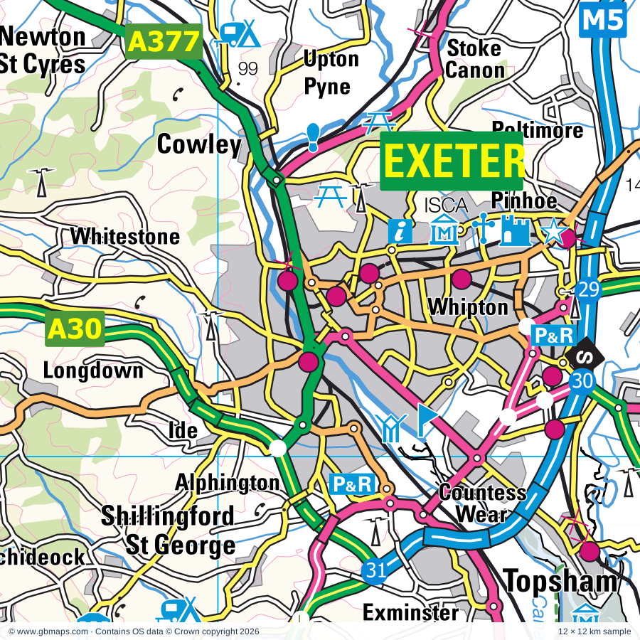
Explore the full 60 × 60 km Exeter regional road map at 1:250,000, covering Topsham, Exmouth, Sidmouth, Dawlish, Chudleigh. Compare the complete coverage below; a detailed PDF sample is available free.

EXETER & SURROUNDING AREAREGIONAL ROAD MAP
60 × 60 km · Full map previewDownload the free SVG ↓

INSIDE THE FULL 60 × 60 KM MAP

Explore the Exeter map area

1:250,000 cartography

Towns, villages & places

More mapped places (238)
  • Farringdon
  • Ebford
  • Clyst St Mary
  • Woodbury
  • Sowton
  • Exton
  • Aylesbeare
  • Cranbrook
  • Rockbeare
  • Hawkerland
  • Exminster
  • Lympstone
  • Powderham
  • Yettington
  • Broadclyst
  • Poltimore
  • Southerton
  • Kenton
  • Whimple
  • Starcross
  • Knowle
  • Metcombe
  • Westwood
  • Harpford
  • Kenn
  • Kennford
  • Otterton
  • Cockwood
  • Ide
  • Budlake
  • Wiggaton
  • Bowd
  • Rewe
  • Cowley
  • Fairmile
  • Talaton
  • Netherexe
  • Dunchideock
  • Hele
  • Langford
  • Whitestone
  • Feniton
  • Ashcombe
  • Up Exe
  • Silverton
  • Sidbury
  • Longdown
  • Plymtree
  • Bradninch
  • Alfington
  • Thorverton
  • Payhembury
  • Westcott
  • Higher Cheriton
  • Doddiscombsleigh
  • Lower Cheriton
  • Mutterton
  • Harcombe
  • Holcombe
  • Efford
  • Gittisham
  • Buckerell
  • Colebrook
  • Luton
  • Trusham
  • Ideford
  • Dulford
  • Cadbury
  • Hookway
  • Coombe
  • Christow
  • Shobrooke
  • Awliscombe
  • Broadhembury
  • Kerswell
  • Bickleigh
  • Butterleigh
  • Fordton
  • Bishopsteignton
  • Bridford
  • Farway
  • Shaldon
  • Hennock
  • Uton
  • Dunsford
  • Kentisbeare
  • Venny Tedburn
  • Branscombe
  • Cadeleigh
  • Northleigh
  • Willand
  • Southleigh
  • Preston
  • Blackborough
  • Sandford
  • Stokeinteignhead
  • Netherton
  • Offwell
  • Upham
  • Well Town
  • Sheldon
  • Teigngrace
  • Heathfield
  • Smithincott
  • Doccombe
  • Dunkeswell
  • Halberton
  • Beer
  • Ashill
  • Monkton
  • Wilmington
  • Lustleigh
  • Widworthy
  • Yeoford
  • Poughill
  • Beacon
  • Uffculme
  • Luppitt
  • Cotleigh
  • Brimley
  • Craddock
  • Coffinswell
  • Daccombe
  • Withleigh
  • Liverton
  • Newbuildings
  • Knowle
  • Crockernwell
  • Abbey
  • Colebrooke
  • Kennerleigh
  • Chettiscombe
  • Colyford
  • Pennymoor
  • Uplowman
  • Kingskerswell
  • Bolham
  • Coleford
  • Woolfardisworthy
  • Appledore
  • Chevithorne
  • Abbotskerswell
  • Calverleigh
  • Ilsington
  • Whitnage
  • Axmouth
  • Culmstock
  • Washfield
  • Rawridge
  • East Mere
  • Copplestone
  • Drewsteignton
  • Shute
  • Haytor Vale
  • Whitford
  • Templeton
  • Manaton
  • Puddington
  • Upottery
  • Bickington
  • Hemyock
  • Dalwood
  • Hittisleigh
  • Loxbeare
  • Sigford
  • Denbury
  • Burlescombe
  • Musbury
  • Westleigh
  • Nicholashayne
  • Oldborough
  • Kilmington
  • Easton
  • Caton
  • Ipplepen
  • Stockland
  • Compton
  • Hillerton
  • Nomansland
  • Combpyne
  • Nymet Tracey
  • Torbryan
  • Down St Mary
  • Rousdon
  • Woodland
  • Marldon
  • Hockworthy
  • Cove
  • Newcott
  • Stoodleigh
  • Bow
  • Stapley
  • Clayhidon
  • Lettaford
  • Wrangway
  • Furley
  • Yarcombe
  • Spreyton
  • Membury
  • Broadhempston
  • Churchinford
  • Witheridge
  • Churchstanton
  • Eastington
  • Rackenford
  • Churchill
  • Ford Street
  • Lapford
  • West Worlington
  • East Worlington
  • Marsh
  • Filleigh
  • Blackmoor
  • Littlehempston
  • Howley
  • Staverton
  • Fyfett
  • Ponsworthy
  • Wambrook
  • Bishopswood
  • Poundsgate
  • Buckfast
  • Creacombe
  • Whitestaunton
  • Angersleigh
  • Dartington
  • Holne
  • Chawleigh
  • Scorriton
  • Pitminster
  • Corfe
  • Week
  • Tigley
  • Meshaw
  • Rattery
  • Curland
  • Harbourneford
  • Bickenhall

Roads across this sheet

M5, A30, A35, A38, A358, A361, A373, A375, A376, A377, A379, A380, A381, A382, A383, A384, A385, A396, A3022, A3051, A3052, A3072, A3126, B3042

More road numbers

B3060, B3096, B3123, B3137, B3161, B3170, B3172, B3174, B3176, B3177, B3178, B3179, B3180, B3181, B3183, B3184, B3192, B3193, B3195, B3199, B3201, B3206, B3212, B3220, B3261, B3344, B3352, B3372, B3380, B3387, B3391, B3440

Rivers & waterways

Exeter Canal, Grand Western Canal, Little Dart River, River Axe, River Bovey, River Clyst, River Culm, River Dalch, River Dart, River Exe, River Kenn, River Otter

More waterways

River Tale, River Taw, River Teign, River Tone, River Yarty, River Yeo

Landmarks & landscape

A-La-Ronde, Ark Pottery, Ashburton Museum, Ashcombe Adventure Centre, Ayshford Solar Farm, Babbacombe Model Village, Becky Falls Beauty Spot, Beer Heritage Centre, Berry Pomeroy Castle, Bickleigh Castle, Bickleigh Mill & Craft Centre, Bicton Park Botanical Gardens, DARTMOOR NATIONAL PARK

More named features

Bicton Woodland Railway, Bill Douglas Centre for the History of Cinema, Bishopsteignton Museum, Blackbury Camp, Bradley Manor, Broadclyst Energy Farm, Buckfast Abbey, Buckfast Butterfly Farm & Otter Sanctuary and Indoor RockClimbing, Burrow Farm Gardens, Bygones Museum, Bystock Solar Farm, Cadhay House, Canonteign Country Park, Canonteign Falls, Castle, Castle Drogo, Catacombs, Church House, Coldharbour Mill, Compton Castle, Craft Centre, Crealy Adventure Park, Dartington Cider Press Centre, Dartington Pottery, Dartington Hall, Dartmoor Visitor Centre, Dawlish Museum, Dawlish Warren National Nature Reserve, Decoy Country Park, Devon & Cornwall Constabulary Museum, Devon Bird of Prey Centre, Devon Railway Centre, Devon Wildlife Centre & Hospital, Devon and Exeter Racecourse, Diggerland, Dunsford and Meadhaydown Wood Nature Reserve, East Dartmoor Woods and Heaths National Nature Reserve, Escot House and Gardens, Exeter Castle, Exeter Cathedral, Fairlynch Museum & Arts Centre, Ferne Animal Sanctuary, Fingle Bridge, Five Mile Hill Solar Farm, Follarton House Gardens and Aboretum, Fursdon House, Fursdon House and Garden, Geoneedle, Go Ape Haldon Forest, Grand Western Canal Country Park, Haldon Belvedere, Holbrook Garden, Homeyards Botanical Gardens, Honiton Museum, Allhallows Museum of Lace and Local Antiquities, Hound Tor, House of Marbles Glass and Teign Valley Glass, Jurassic Coast (World Heritage Site), Kents Cavern, Killerton, Killerton House, Kirkham House, Knightshayes Court, Lawrence Castle (Haldon Belvedere), Living Coasts, Manor Mill, Marker's Cottage, Monument, Moretonhampstead Motor Museum, Museum, Nature Reserve Visitor Centre, Newton Abbot Racecourse, Newton Abbot Town & GWR Museum, Occombe Farm Attraction, Orchid Paradise, Otterhead Lakes Nature Reserve, Otterton Mill Pottery, Pecorama Pleasure Gardens, Pennywell Farm & Wildlife Centre, Plant World Gardens, Powderham Castle, Rare Breeds Farm, River Dart Country Park, Riverside Valley Park, Royal Albert Museum, Underground Passages Museum, Tuckers Hall Museum, St Nicholas Priory, Connections Discovery Centre & Exeter Museum, Sand, Seaton Museum, Seaton and District Electric Tramway, Shaldon Wildlife Trust, Shute Barton, Smeatharpe Stadium, Solar Farm, South Devon Railway, St Lawrence Chapel Heritage, Cultural and Community Centre, St Marys Church, Stockland Great Castle, Stone Lane Gardens and Arboretum, Stover Country Park, Interpretation Centre, Teignmouth Museum, The Donkey Sanctuary, The Old Bakery, Manor Mill, The Rock Gardens, The Valiant Soldier Museum and Heritage Centre, Tiverton Castle, Tiverton Museum, Topsham Museum, Torquay Natural History Museum, Torre Abbey, Totnes Castle, Totnes Guildhall, Totnes Museum & Elizabethan House, Devonshire Collection Of Period Costume, Trago Mills Leisure Park, Tuckers Maltings, Ugbrooke House, Ugbrooke House and Gardens, Woodbury Pottery, World of Country Life, Yearlstone Vineyard
Local authority & parish coverage

Wholly or partly within the full map rectangle. These boundaries are coverage information, not additional artwork layers.

  • East Devon DistrictPartly within
  • Exeter DistrictWholly within
  • Mid Devon DistrictPartly within
  • North Devon DistrictPartly within
  • SomersetPartly within
  • South Hams DistrictPartly within
  • Teignbridge DistrictPartly within
  • TorbayPartly within
  • West Devon DistrictPartly within
Wards & electoral divisions 119 areas
  • Alphington Ward
  • Ambrook Ward
  • Ashburton & Buckfastleigh Ward (part)
  • Axminster Ward (part)
  • Barton with Watcombe Ward
  • Beer & Branscombe Ward
  • Bishop's Nympton Ward (part)
  • Bishopsteignton Ward
  • Bovey Ward
  • Bradley Ward
  • Bradninch Ward
  • Broadclyst Ward
  • Buckland & Milber Ward
  • Budleigh & Raleigh Ward
  • Bushell Ward
  • Cadbury Ward
  • Canonsleigh Ward (part)
  • Chagford Ward (part)
  • Chittlehampton Ward (part)
  • Chudleigh Ward
  • Chulmleigh Ward (part)
  • Clare & Shuttern Ward (part)
  • Clifton with Maidenway Ward (part)
  • Clyst Valley Ward
  • Cockington with Chelston Ward
  • Collaton St. Mary Ward (part)
  • College Ward
  • Coly Valley Ward
  • Cranbrook Ward
  • Crediton Boniface Ward
  • Crediton Lawrence Ward
  • Cullompton Padbrook Ward
  • Cullompton St. Andrews Ward
  • Cullompton Vale Ward
  • Dartington & Staverton Ward (part)
  • Dawlish North East Ward
  • Dawlish South West Ward
  • Drewsteignton Ward (part)
  • Dunkeswell & Otterhead Ward
  • Duryard & St. James Ward
  • Ellacombe Ward
  • Exbourne Ward (part)
  • Exe Valley Ward
  • Exmouth Brixington Ward
  • Exmouth Halsdon Ward
  • Exmouth Littleham Ward
  • Exmouth Town Ward
  • Exmouth Withycombe Raleigh Ward
  • Exwick Ward
  • Feniton Ward
  • Goodrington with Roselands Ward (part)
  • Halberton Ward
  • Haytor Ward
  • Heavitree Ward
  • Honiton St. Michael's Ward
  • Honiton St. Paul's Ward
  • Ipplepen Ward
  • Kenn Valley Ward
  • Kenton & Starcross Ward
  • Kerswell-with-Combe Ward
  • King's Ash Ward
  • Kingsteignton East Ward
  • Kingsteignton West Ward
  • Lower Culm Ward
  • Marldon & Littlehempston Ward (part)
  • Mincinglake & Whipton Ward
  • Moretonhampstead Ward (part)
  • Newbridges Ward (part)
  • Newton Poppleford & Harpford Ward
  • Newtown & St. Leonard's Ward
  • Ottery St. Mary Ward
  • Pennsylvania Ward
  • Pinhoe Ward
  • Preston Ward
  • Priory Ward
  • Roundham with Hyde Ward (part)
  • Sandford & Creedy Ward
  • Seaton Ward
  • Shaldon & Stokeinteignhead Ward
  • Shiphay Ward
  • Sidmouth Rural Ward
  • Sidmouth Sidford Ward
  • Sidmouth Town Ward
  • Silverton Ward
  • South Brent Ward (part)
  • St. David's Ward
  • St. Loyes Ward
  • St. Marychurch Ward
  • St. Thomas Ward
  • Tale Vale Ward
  • Taw Vale Ward (part)
  • Teign Valley Ward
  • Teignmouth Central Ward
  • Teignmouth East Ward
  • Teignmouth West Ward
  • Tiverton Castle Ward
  • Tiverton Cranmore Ward
  • Tiverton Lowman Ward (part)
  • Tiverton Westexe Ward
  • Topsham Ward
  • Tormohun Ward
  • Totnes Ward (part)
  • Trinity Ward (part)
  • Upper Culm Ward
  • Upper Yeo & Taw Ward (part)
  • Way Ward
  • Wellswood Ward (part)
  • West Dart Ward (part)
  • West Hill & Aylesbeare Ward
  • Whimple & Rockbeare Ward
  • Witheridge Ward (part)
  • Woodbury & Lympstone Ward
  • Yarty Ward (part)
  • Yeo Ward
  • Blackdown & Neroche ED (part)
  • Chard North ED (part)
  • Ilminster ED (part)
  • Upper Tone ED (part)
  • Wellington ED (part)
Civil parishes & communities 221 areas
  • Abbotskerswell CP
  • All Saints CP (part)
  • Ashburton CP
  • Ashcombe CP
  • Ashill CP (part)
  • Ashton CP
  • Awliscombe CP
  • Axminster CP (part)
  • Axmouth CP
  • Aylesbeare CP
  • Beer CP
  • Berry Pomeroy CP (part)
  • Bickenhall CP (part)
  • Bickington CP
  • Bickleigh CP
  • Bicton CP
  • Bishopsteignton CP
  • Bovey Tracey CP
  • Bow CP
  • Bradninch CP
  • Brampford Speke CP
  • Branscombe CP
  • Bridford CP
  • Broad Clyst CP
  • Broadhembury CP
  • Broadhempston CP
  • Broadway CP (part)
  • Buckerell CP
  • Buckfastleigh CP
  • Buckland St. Mary CP
  • Buckland in the Moor CP
  • Budleigh Salterton CP
  • Burlescombe CP
  • Butterleigh CP
  • Cadbury CP
  • Cadeleigh CP
  • Chagford CP (part)
  • Chardstock CP (part)
  • Chawleigh CP (part)
  • Cheriton Bishop CP
  • Cheriton Fitzpaine CP
  • Christow CP
  • Chudleigh CP
  • Chulmleigh CP (part)
  • Churchstanton CP
  • Clannaborough CP
  • Clayhidon CP
  • Clyst Honiton CP
  • Clyst Hydon CP
  • Clyst St. George CP
  • Clyst St. Lawrence CP
  • Clyst St. Mary CP
  • Coffinswell CP
  • Colaton Raleigh CP
  • Coldridge CP (part)
  • Colebrooke CP
  • Colyford CP
  • Colyton CP
  • Combe Raleigh CP
  • Combe St. Nicholas CP (part)
  • Combpyne Rousdon CP (part)
  • Copplestone CP
  • Corfe CP (part)
  • Cotleigh CP
  • Cranbrook CP
  • Crediton CP
  • Crediton Hamlets CP
  • Cruwys Morchard CP
  • Cullompton CP
  • Culmstock CP
  • Curland CP
  • Dalwood CP
  • Dartington CP (part)
  • Dawlish CP
  • Dean Prior CP (part)
  • Denbury and Torbryan CP
  • Doddiscombsleigh CP
  • Down St. Mary CP
  • Drewsteignton CP (part)
  • Dunchideock CP
  • Dunkeswell CP
  • Dunsford CP
  • East Budleigh CP
  • East Worlington CP
  • Exminster CP
  • Exmouth CP
  • Farringdon CP
  • Farway CP
  • Feniton CP
  • Gittisham CP
  • Haccombe with Combe CP
  • Halberton CP
  • Harberton CP (part)
  • Hatch Beauchamp CP (part)
  • Hemyock CP
  • Hennock CP
  • Hittisleigh CP
  • Hockworthy CP (part)
  • Holcombe Burnell CP
  • Holcombe Rogus CP (part)
  • Holne CP (part)
  • Honiton CP
  • Huntsham CP (part)
  • Huxham CP
  • Ide CP
  • Ideford CP
  • Ilsington CP
  • Ipplepen CP
  • Kenn CP
  • Kennerleigh CP
  • Kentisbeare CP
  • Kenton CP
  • Kilmington CP
  • King's Nympton CP (part)
  • Kingskerswell CP
  • Kingsteignton CP
  • LCPs of Axminster and Kilmington
  • Lapford CP
  • Littlehempston CP
  • Loxbeare CP
  • Luppitt CP
  • Lustleigh CP
  • Lympstone CP
  • Mamhead CP
  • Manaton CP (part)
  • Marldon CP
  • Membury CP
  • Meshaw CP (part)
  • Monkton CP
  • Morchard Bishop CP
  • Moretonhampstead CP
  • Musbury CP (part)
  • Nether Exe CP
  • Newton Abbot CP
  • Newton Poppleford and Harpford CP
  • Newton St. Cyres CP
  • North Bovey CP (part)
  • North Tawton CP (part)
  • Northleigh CP
  • Nymet Rowland CP
  • Oakford CP (part)
  • Offwell CP
  • Ogwell CP
  • Orchard Portman CP (part)
  • Otterford CP
  • Otterton CP
  • Ottery St. Mary CP
  • Payhembury CP
  • Pitminster CP (part)
  • Plymtree CP
  • Poltimore CP
  • Poughill CP
  • Powderham CP
  • Puddington CP
  • Rackenford CP (part)
  • Rattery CP (part)
  • Rewe CP
  • Rockbeare CP
  • Romansleigh CP (part)
  • Rose Ash CP (part)
  • Sampford Arundel CP
  • Sampford Peverell CP
  • Sandford CP
  • Seaton CP
  • Shaldon CP
  • Sheldon CP
  • Shillingford St. George CP
  • Shobrooke CP
  • Shute CP
  • Sidmouth CP
  • Silverton CP
  • South Brent CP (part)
  • Southleigh CP
  • Sowton CP
  • Spreyton CP (part)
  • Staple Fitzpaine CP
  • Starcross CP
  • Staverton CP
  • Stawley CP (part)
  • Stockland CP
  • Stockleigh English CP
  • Stockleigh Pomeroy CP
  • Stoke Canon CP
  • Stokeinteignhead CP
  • Stoodleigh CP (part)
  • Talaton CP
  • Tedburn St. Mary CP
  • Teigngrace CP
  • Teignmouth CP
  • Templeton CP
  • Thelbridge CP
  • Thorverton CP
  • Tiverton CP (part)
  • Totnes CP (part)
  • Trusham CP
  • Uffculme CP
  • Uplowman CP
  • Upottery CP
  • Upton Hellions CP
  • Upton Pyne CP
  • Wambrook CP (part)
  • Washfield CP
  • Washford Pyne CP
  • Wellington CP (part)
  • Wellington Without CP (part)
  • West Buckfastleigh CP (part)
  • West Buckland CP (part)
  • West Hatch CP (part)
  • West Hill CP
  • Whimple CP
  • Whitestaunton CP
  • Whitestone CP
  • Widecombe in the Moor CP (part)
  • Widworthy CP
  • Willand CP
  • Witheridge CP
  • Woodbury CP
  • Woodland CP
  • Woolfardisworthy CP
  • Yarcombe CP
  • Zeal Monachorum CP (part)

Source: the GBMaps road atlas, OS Boundary-Line and postcode mapping datasets. Source editions are being checked for publication. Unmarked boundary names are wholly within the sheet; “part” means the map edge crosses the area.

Place lists are selected from the map source, not a complete gazetteer. Named features describe the cartography; visitor facilities and opening status are not verified. The free sample covers only 12 × 12 km of this larger sheet.

INSIDE YOUR DOWNLOAD

A proper road map, in useful formats

Road classifications, towns and villages, railways, rivers, landscape detail and tourist symbols, brought together in the GBMaps regional road atlas style.

PDF filePDFSVG fileSVGAdobe Illustrator AI fileAi

PDF for the finished map. SVG and layered Illustrator artwork for adapting colours, adding your own information and preparing designs.

THE FINISHED SHEET

Designed for print and presentation

Map coverage
60 × 60 km
Sample coverage
12 × 12 km
Print layout
A3 landscape · enlarged 1:250k cartography
Sheet furniture
Border, scale bar, key & north arrow

A few useful details

What changes when I select another square?

Select a surrounding square to bring it into the centre and reveal the maps around it. Each square is a different 60 × 60 km map. The preview, free sample and selected download change together. Neighbouring sheets overlap by 30 km so you can choose the coverage that suits you.

Is the free sample a vector map?

The on-page detail is an SVG. The free download is a separate 12 × 12 km PDF with a link to the full map. Please retain its copyright credits and product link when sharing it.

Can I buy a larger combined map?

These downloads are individual ready-made sheets. Contact GBMaps if you need a larger combined area.

FREE PDF SAMPLE

Your free map sample

Your free 12 × 12 km sample includes a link back to this map, so you can return for the full area whenever you need it.

Download free PDF sample ↓

Get your Exeter map

Map download bundle

£24.00including VATOne payment

Pay securely

One payment. Your map stays open.

Your map download

Your map files

Preparing your download…

Checking your private download link…

Your map downloads

Already bought a map?

Find the downloads from your purchases.

Enter the email address you used at checkout. We’ll email you a private link to your available map downloads.