Ely regional road map. Full 60 × 60 km PDF, SVG and Illustrator files, with a free PDF sample.

GBMAPS.COM

Ely Regional Road Map

Call Us Now for Help01751 473136

GREAT BRITAIN ROAD ATLAS · 1:250,000 GB-570-0300

Ely & surrounding area

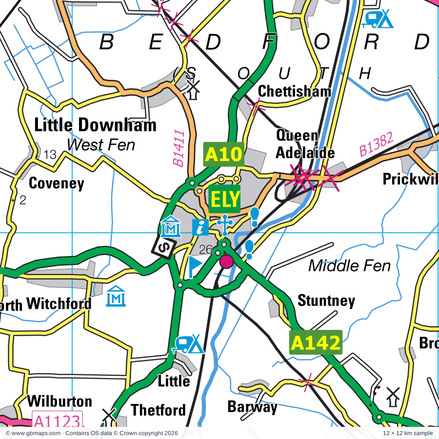
Explore the full 60 × 60 km Ely regional road map at 1:250,000, covering Ely, Swaffham, Brandon, Watton, Thetford. Compare the complete coverage below; a detailed PDF sample is available free.

ELY & SURROUNDING AREAREGIONAL ROAD MAP
60 × 60 km · Full map previewDownload the free SVG ↓

INSIDE THE FULL 60 × 60 KM MAP

Explore the Ely map area

1:250,000 cartography

Towns, villages & places

More mapped places (211)
  • Methwold Hythe
  • Barton Bendish
  • Methwold
  • Crimplesham
  • Stradsett
  • Northwold
  • Gooderstone
  • Foulden
  • Fincham
  • Beachamwell
  • Bexwell
  • Hilgay
  • Fordham
  • Denver
  • Stow Bardolph
  • Feltwell
  • Cranwich
  • Shouldham
  • Southery
  • Wimbotsham
  • Marham
  • Ten Mile Bank
  • Cockley Cley
  • Mundford
  • Stow Bridge
  • Hilborough
  • Ickburgh
  • Runcton Holme
  • Tottenhill
  • Wormegay
  • Bodney
  • Weeting
  • Narborough
  • Watlington
  • Pentney
  • Nordelph
  • Setchey
  • West Bilney
  • West Tofts
  • Middleton
  • East Winch
  • Lakenheath
  • East Walton
  • West Acre
  • Little Cressingham
  • Wangford
  • South Acre
  • Saddle Bow
  • Sporle
  • Welney
  • Lakes End
  • Littleport
  • Gayton Thorpe
  • Outwell
  • Ashill
  • Castle Acre
  • Gayton
  • Upwell
  • Bawsey
  • Emneth Hungate
  • Newton
  • Necton
  • Kenny Hill
  • Holme Hale
  • Prickwillow
  • Merton
  • Christchurch
  • Croxton
  • Emneth
  • Ivy Todd
  • Eriswell
  • Pott Row
  • Beck Row
  • West Lexham
  • Chettisham
  • Grimston
  • Thompson
  • Ovington
  • Clenchwarton
  • Roydon
  • East Lexham
  • Elveden
  • Congham
  • East Wretham
  • Bradenham
  • Little Downham
  • Elm
  • Griston
  • Rougham
  • Stonebridge
  • Pymoor
  • Manea
  • Great Massingham
  • Carbrooke
  • Northacre
  • Begdale
  • Hillington
  • Beeston
  • Litcham
  • Broad Hill
  • Caston
  • Little Massingham
  • Stuntney
  • Weasenham All Saints
  • Isleham
  • Barton Mills
  • Worlington
  • West Walton
  • Wendling
  • Illington
  • Breckles
  • Coldham
  • Weasenham St Peter
  • Flitcham
  • Shipdham
  • Barnham
  • Ingleborough
  • Harpley
  • West Newton
  • Coveney
  • Icklingham
  • Leverington
  • Wellingham
  • Freckenham
  • Scarning
  • Brettenham
  • Tittleshall
  • Euston
  • Cranworth
  • Scoulton
  • Sandringham
  • Barway
  • Tuddenham
  • Mileham
  • Wolferton
  • Woodrising
  • Rushford
  • Longham
  • Witchford
  • Houghton
  • Shropham
  • Bridgham
  • Wimblington
  • Podmore
  • Larling
  • Bittering
  • Anmer
  • Pockthorpe
  • Southburgh
  • Fordham
  • South Raynham
  • Herringswell
  • Cavenham
  • Horseway
  • West Rudham
  • Fitton End
  • Westfield
  • Wentworth
  • Gorefield
  • Snetterton
  • Wordwell
  • East Rudham
  • Witcham
  • Lackford
  • Stanfield
  • Gressenhall
  • Helhoughton
  • Stretham
  • East Bilney
  • Wicken
  • Whissonsett
  • Flempton
  • Tydd St Mary
  • Mepal
  • Beetley
  • Coxford
  • Oxwick
  • Brisley
  • Horningtoft
  • Tatterford
  • Old Beetley
  • Ingham
  • Sapiston
  • Ampton
  • Wilburton
  • Sutton
  • Guy's Head
  • Gasthorpe
  • Toftrees
  • Upware
  • Hoe
  • Haddenham
  • Troston
  • Colkirk
  • Shereford
  • Hopton
  • Barningham
  • Gateley
  • Bardwell
  • Worthing
  • Hempton
  • Aldreth
  • Lutton
  • Ixworth
  • Stanton
  • Hepworth
  • Gedney
  • Upthorpe
  • Guist
  • Stibbard
  • Willingham

Roads across this sheet

A10, A11, A17, A134, A141, A142, A143, A148, A149, A1065, A1066, A1067, A1075, A1076, A1078, A1088, A1101, A1122, A1123, A1421, B198, B1049, B1050, B1077

More road numbers

B1085, B1093, B1094, B1098, B1099, B1100, B1101, B1102, B1104, B1106, B1107, B1108, B1110, B1111, B1112, B1135, B1144, B1145, B1146, B1153, B1160, B1165, B1166, B1169, B1359, B1381, B1382, B1386, B1390, B1411, B1439, B1440, B1454

Rivers & waterways

Babingley River, Canal, Counter Drain, Forty Foot or Vermuden's Drain, Little Ouse River, Middle Level Main Drain, New Bedford River or Hundred Foot Drain, New River, Old Bedford River, Old Croft R, Old Croft River, Popham's Eau

More waterways

Relief Channel, River Cam, River Delph, River Great Ouse, River Kennett, River Lark, River Nar, River Nene, River Nene ( old course ), River Nene (old course), River Thet, River Tud, River Wensum, River Wissey, River Yare, Sixteen Foot Drain, South Holland Main Drain, Twenty Foot River, Well Creek, White Mill Drain

Landmarks & landscape

Adventure Activity Centre, African Violet Centre, Ampton Point to Point Racecourse, Ancient House Museum, Charles Burrell Museum, Apes Hall, Bailey Gate, Bailey Gate (Castle Acre), Bardwell Windmill, Bishop Bonner's Cottage Museum, Gordon Boswell Romany Museum, Brandon Country Park, Brandon Country Visitor Centre, Brandon Heritage Museum

More named features

Caithness Glass, Castle Acre, Castle Acre Priory (remains of), Castle Rising, Cavenham Heath Nature Reserve, Chittering Solar Farm, Church of the Holy Sepulchre, Cockley Cley Museum, Collectors World, Congham Hotel Gardens, County School Station, Denver Mill, Desert Rats Memorial, East Wretham Heath Nature Reserve, Ely Cathedral, Ely Museum, Stained Glass Museum, Euston Hall, Euston Watermill, Fakenham Racecourse, Fakenham Point to Point Racecourse, Fenland Aviation Museum, Flying Eight Balls Museum, Fort, Go Ape Thetford, Gooderstone Water Gardens, Gressenhall Farm and Workhouse, Grimes Graves Flint Mines, Grimes Graves Flint Mines & Visitor centre, Hall Farm, High Lodge Forest Centre, Go Ape Thetford, Hoe Rough Nature Reserve, Honeypot Wood Nature Reserve, Houghton Garden, Houghton Hall and Garden, Houghton House, Iceni Brewery, Isleham Priory Church, Kilverstone Hall, King's Lynn Arts Centre, Kings Lynn Custom House, Lynn Museum, True's Yard Museum, Martriotts Warehouse, Knettishall Heath Country Park, Lackford Wildfowl Nature Reserve, Letton Hall, Litcham Common Nature Reserve, Little Cressingham Mill, Lynford Arboretum, March Museum, Meadow Farm Solar Farm, Melsop Farm Park, Mid Norfolk Railway (Tourist Railway), Middleton Mount (Antiquity feature), Mildenhall Stadium Motor Racing Circuit, Mildenhall and District Museum, Mingay Park Solar Farm, Museum Of Norfolk Rural Life, Ouse Washes Nature Reserve, Ouse Washes Visitor Centre, Oxborough Hall, Oxborough Wood Nature Reserve, Oxburgh Hall, Peckover House, Pensthorpe Natural Park, Prickwillow Drainage Engine Museum, Priory, RAF Witchford Display, Rare Breeds Farm, Reaches Farm Solar Farm, Ryston Solar Farm, Sandringham Country Park, Sandringham House, Sandringham House Visitor Centre, Sandringham House and Garden, Saxon Cathedral (remains of), Solar Farm, St Georges Distillery, Stanton Post Mill, Stowbridge Solar Park, Swaffham Museum, Swaffham Raceway, The Green Britain Centre, Thetford Church of the Holy Sepulchre, Thetford Priory, Thetford Warren Lodge, Trinity Hospital, Visitor Centre, Wallington Hall, Walpole Water Gardens, Weeting Castle, Weeting Heath Nature Reserve, Welney Wetland Centre Visitor Centre, Welney Wildfowl Refuge, West Acre Gardens, West Stow Anglo-Saxon Village, Lackford Lakes Visitor Centre, West Stow Country Park, Wicken Fen Nature Reserve, Wicken Fen Visitor Centre, Wisbech & Fenland Museum, Octavia Hill Birthplace Museum, Woodhouse Farm Park, Wyken Hall, Wyken Vineyard
Local authority & parish coverage

Wholly or partly within the full map rectangle. These boundaries are coverage information, not additional artwork layers.

  • Breckland DistrictPartly within
  • East Cambridgeshire DistrictPartly within
  • Fenland DistrictPartly within
  • King's Lynn and West Norfolk DistrictPartly within
  • Mid Suffolk DistrictPartly within
  • North Norfolk DistrictPartly within
  • South Cambridgeshire DistrictPartly within
  • South Holland DistrictPartly within
  • South Norfolk DistrictPartly within
  • West Suffolk DistrictPartly within
Wards & electoral divisions 113 areas
  • Airfield Ward
  • All Saints & Wayland Ward (part)
  • Ashill Ward
  • Bardwell Ward
  • Barningham Ward (part)
  • Bedingfeld Ward
  • Bircham with Rudhams Ward (part)
  • Brandon Central Ward
  • Brandon East Ward
  • Brandon West Ward
  • Burwell Ward (part)
  • Chatteris North & Manea Ward (part)
  • Chatteris South Ward (part)
  • Clenchwarton Ward
  • Cottenham Ward (part)
  • Denver Ward
  • Dereham Neatherd Ward (part)
  • Dereham Toftwood Ward
  • Dereham Withburga Ward
  • Dersingham Ward (part)
  • Doddington & Wimblington Ward (part)
  • Downham Old Town Ward
  • Downham Villages Ward
  • East Downham Ward
  • Elm & Christchurch Ward (part)
  • Ely East Ward
  • Ely North Ward
  • Ely West Ward
  • Emneth & Outwell Ward
  • Fairstead Ward
  • Feltwell Ward
  • Fleet Ward (part)
  • Fordham & Isleham Ward (part)
  • Forest Ward
  • Gayton & Grimston Ward
  • Gaywood Chase Ward
  • Gaywood Clock Ward
  • Gaywood North Bank Ward
  • Gedney Ward (part)
  • Guiltcross Ward (part)
  • Haddenham Ward (part)
  • Harling & Heathlands Ward (part)
  • Hermitage Ward
  • Hingham & Deopham Ward (part)
  • Holbeach Hurn Ward (part)
  • Iceni Ward (part)
  • Ixworth Ward (part)
  • Lakenheath Ward
  • Lancaster North Ward (part)
  • Lancaster South Ward (part)
  • Launditch Ward
  • Leverington & Wisbech Rural Ward (part)
  • Lincoln Ward (part)
  • Littleport Ward
  • Long Sutton Ward (part)
  • Manor Ward (part)
  • March East Ward
  • March North Ward
  • March South Ward
  • March West & Benwick Ward (part)
  • Massingham with Castle Acre Ward
  • Mattishall Ward (part)
  • Methwold Ward
  • Mildenhall Great Heath Ward
  • Mildenhall Kingsway & Market Ward
  • Mildenhall Queensway Ward
  • Milton & Waterbeach Ward (part)
  • Nar Valley Ward
  • Necton Ward
  • North Downham Ward
  • North Lynn Ward
  • Over & Willingham Ward (part)
  • Pakenham & Troston Ward (part)
  • Parson Drove & Wisbech St. Mary Ward (part)
  • Risby Ward (part)
  • Saham Toney Ward (part)
  • Shipdham-with-Scarning Ward (part)
  • Soham North Ward
  • Soham South Ward (part)
  • South & West Lynn Ward
  • South Downham Ward
  • Springwood Ward
  • St. Margaret's with St. Nicholas Ward
  • Stanton Ward (part)
  • Stibbard Ward (part)
  • Stretham Ward
  • Sutton Bridge Ward
  • Sutton Ward (part)
  • Swaffham Ward
  • Terrington Ward (part)
  • The Raynhams Ward (part)
  • The Rows Ward
  • The Saints Ward (part)
  • The Woottons Ward (part)
  • Thetford Boudica Ward
  • Thetford Burrell Ward
  • Thetford Castle Ward
  • Thetford Priory Ward
  • Thurston Ward (part)
  • Tilney, Mershe Lande & Wiggenhall Ward
  • Upper Wensum Ward (part)
  • Upwell & Delph Ward
  • Walsham-le-Willows Ward (part)
  • Walsingham Ward (part)
  • Walsoken, West Walton & Walpole Ward
  • Watlington Ward
  • Watton Ward
  • West Winch Ward
  • Wisbech North Ward
  • Wisbech Riverside Ward
  • Wisbech South Ward
  • Wisbech Walsoken & Waterlees Ward
  • Wissey Ward
Civil parishes & communities 277 areas
  • Ampton CP (part)
  • Anmer CP (part)
  • Ashill CP
  • Badwell Ash CP (part)
  • Bardwell CP
  • Barnham CP
  • Barningham CP
  • Barton Bendish CP
  • Barton Mills CP
  • Bawsey CP
  • Beachamwell CP
  • Beck Row, Holywell Row and Kenny Hill CP
  • Beeston with Bittering CP
  • Beetley CP
  • Billingford CP (part)
  • Bintree CP (part)
  • Bircham CP (part)
  • Boughton CP
  • Bradenham CP
  • Brandon CP
  • Brettenham CP
  • Bridgham CP
  • Brisley CP
  • Burwell CP (part)
  • Carbrooke CP
  • Castle Acre CP
  • Castle Rising CP
  • Caston CP
  • Cavenham CP (part)
  • Chatteris CP (part)
  • Chippenham CP (part)
  • Christchurch CP
  • Clenchwarton CP
  • Cockley Cley CP
  • Colkirk CP
  • Coney Weston CP
  • Congham CP
  • Cottenham CP (part)
  • Coveney CP
  • Cranwich CP
  • Cranworth CP (part)
  • Crimplesham CP
  • Croxton CP
  • Culford CP (part)
  • Denver CP
  • Dereham CP (part)
  • Dersingham CP (part)
  • Didlington CP
  • Doddington CP (part)
  • Downham CP
  • Downham Market CP
  • Downham West CP
  • Dunton CP (part)
  • East Rudham CP (part)
  • East Walton CP
  • East Winch CP
  • Elm CP (part)
  • Elveden CP
  • Ely CP
  • Emneth CP
  • Eriswell CP
  • Euston CP
  • Fakenham CP (part)
  • Fakenham Magna CP
  • Feltwell CP
  • Fincham CP
  • Fleet CP (part)
  • Flempton CP (part)
  • Flitcham with Appleton CP
  • Fordham CP (part)
  • Fordham CP
  • Foulden CP
  • Fransham CP
  • Freckenham CP
  • Fulmodeston CP (part)
  • Garboldisham CP (part)
  • Garvestone, Reymerston and Thuxton CP (part)
  • Gateley CP
  • Gayton CP
  • Gedney CP (part)
  • Gooderstone CP
  • Gorefield CP (part)
  • Great Cressingham CP
  • Great Dunham CP
  • Great Livermere CP (part)
  • Great Massingham CP
  • Gressenhall CP
  • Grimston CP
  • Griston CP
  • Guist CP (part)
  • Haddenham CP (part)
  • Harling CP (part)
  • Harpley CP
  • Helhoughton CP
  • Hempton CP
  • Hepworth CP
  • Herringswell CP (part)
  • Hilborough CP
  • Hilgay CP
  • Hillington CP
  • Hingham CP (part)
  • Hockham CP
  • Hockwold cum Wilton CP
  • Hoe and Worthing CP (part)
  • Holbeach CP (part)
  • Holme Hale CP
  • Honington CP
  • Hopton CP (part)
  • Horningtoft CP
  • Houghton CP (part)
  • Ickburgh CP
  • Icklingham CP
  • Ingham CP (part)
  • Isleham CP
  • Ixworth CP (part)
  • Ixworth Thorpe CP
  • Kempstone CP
  • Kettlestone CP (part)
  • Kilverstone CP
  • Knettishall CP
  • Lackford CP (part)
  • Lakenheath CP
  • Langham CP (part)
  • Leverington CP
  • Lexham CP
  • Leziate CP
  • Litcham CP
  • Little Cressingham CP
  • Little Dunham CP
  • Little Ellingham CP (part)
  • Little Livermere CP
  • Little Massingham CP
  • Little Sutton CP
  • Littleport CP
  • Long Sutton CP (part)
  • Longham CP
  • Lutton CP
  • Lynford CP
  • Manea CP (part)
  • March CP (part)
  • Marham CP
  • Market Weston CP
  • Marshland St. James CP
  • Mepal CP
  • Merton CP
  • Methwold CP
  • Middleton CP
  • Mildenhall High CP
  • Mileham CP
  • Mundford CP
  • Narborough CP
  • Narford CP
  • Necton CP
  • Newton By Castle Acre CP
  • Newton-in-the-Isle CP (part)
  • Nordelph CP
  • North Elmham CP (part)
  • North Pickenham CP
  • North Runcton CP
  • North Wootton CP (part)
  • Northwold CP
  • Outwell CP
  • Ovington CP
  • Oxborough CP
  • Pakenham CP (part)
  • Parson Drove CP (part)
  • Pentney CP
  • Pudding Norton CP
  • Quidenham CP (part)
  • Rampton CP (part)
  • Raynham CP
  • Red Lodge CP (part)
  • Riddlesworth CP
  • Rocklands CP (part)
  • Roudham and Larling CP
  • Rougham CP
  • Roydon CP
  • Runcton Holme CP
  • Ryburgh CP
  • Ryston CP
  • Saham Toney CP
  • Sandringham CP (part)
  • Santon Downham CP
  • Sapiston CP
  • Scarning CP
  • Scoulton CP (part)
  • Sculthorpe CP (part)
  • Shipdham CP
  • Shouldham CP
  • Shouldham Thorpe CP
  • Shropham CP (part)
  • Snetterton CP (part)
  • Soham CP
  • South Acre CP
  • South Pickenham CP
  • South Wootton CP
  • Southery CP
  • Sporle with Palgrave CP
  • Stanfield CP
  • Stanford CP
  • Stanton CP (part)
  • Stibbard CP (part)
  • Stoke Ferry CP
  • Stow Bardolph CP
  • Stow Bedon and Breckles CP
  • Stowlangtoft CP (part)
  • Stradsett CP
  • Stretham CP
  • Sturston CP
  • Sutton Bridge CP
  • Sutton CP (part)
  • Sutton St. James CP (part)
  • Swaffham CP
  • Swanton Morley CP (part)
  • Tattersett CP (part)
  • Terrington St. Clement CP (part)
  • Terrington St. John CP
  • Thelnetham CP (part)
  • Thetford CP
  • Thetford CP
  • Thompson CP
  • Tilney All Saints CP
  • Tilney St. Lawrence CP
  • Timworth CP (part)
  • Tittleshall CP
  • Tottenhill CP
  • Tottington CP
  • Troston CP
  • Tuddenham CP (part)
  • Twyford CP (part)
  • Tydd St. Giles CP (part)
  • Tydd St. Mary CP
  • Upwell CP
  • Walpole CP
  • Walpole Cross Keys CP
  • Walpole Highway CP
  • Walsham-le-Willows CP (part)
  • Walsoken CP
  • Waterbeach CP (part)
  • Watlington CP
  • Wattisfield CP (part)
  • Watton CP
  • Weasenham All Saints CP
  • Weasenham St. Peter CP
  • Weeting-with-Broomhill CP
  • Wellingham CP
  • Welney CP
  • Wendling CP
  • Wentworth CP
  • Wereham CP
  • West Acre CP
  • West Dereham CP
  • West Row CP
  • West Rudham CP
  • West Stow CP
  • West Walton CP
  • West Winch CP
  • Whinburgh and Westfield CP (part)
  • Whissonsett CP
  • Wicken CP (part)
  • Wiggenhall St. Germans CP
  • Wiggenhall St. Mary Magdalen CP
  • Wilburton CP
  • Willingham CP (part)
  • Wimblington CP (part)
  • Wimbotsham CP
  • Wisbech CP
  • Wisbech St. Mary CP (part)
  • Witcham CP
  • Witchford CP
  • Wood Norton CP (part)
  • Wordwell CP
  • Worlington CP
  • Wormegay CP
  • Wretham CP
  • Wretton CP
  • Yaxham CP (part)

Source: the GBMaps road atlas, OS Boundary-Line and postcode mapping datasets. Source editions are being checked for publication. Unmarked boundary names are wholly within the sheet; “part” means the map edge crosses the area.

Place lists are selected from the map source, not a complete gazetteer. Named features describe the cartography; visitor facilities and opening status are not verified. The free sample covers only 12 × 12 km of this larger sheet.

INSIDE YOUR DOWNLOAD

A proper road map, in useful formats

Road classifications, towns and villages, railways, rivers, landscape detail and tourist symbols, brought together in the GBMaps regional road atlas style.

PDF filePDFSVG fileSVGAdobe Illustrator AI fileAi

PDF for the finished map. SVG and layered Illustrator artwork for adapting colours, adding your own information and preparing designs.

THE FINISHED SHEET

Designed for print and presentation

Map coverage
60 × 60 km
Sample coverage
12 × 12 km
Print layout
A3 landscape · enlarged 1:250k cartography
Sheet furniture
Border, scale bar, key & north arrow

A few useful details

What changes when I select another square?

Select a surrounding square to bring it into the centre and reveal the maps around it. Each square is a different 60 × 60 km map. The preview, free sample and selected download change together. Neighbouring sheets overlap by 30 km so you can choose the coverage that suits you.

Is the free sample a vector map?

The on-page detail is an SVG. The free download is a separate 12 × 12 km PDF with a link to the full map. Please retain its copyright credits and product link when sharing it.

Can I buy a larger combined map?

These downloads are individual ready-made sheets. Contact GBMaps if you need a larger combined area.

FREE PDF SAMPLE

Your free map sample

Your free 12 × 12 km sample includes a link back to this map, so you can return for the full area whenever you need it.

Download free PDF sample ↓

Get your Ely map

Map download bundle

£24.00including VATOne payment

Pay securely

One payment. Your map stays open.

Your map download

Your map files

Preparing your download…

Checking your private download link…

Your map downloads

Already bought a map?

Find the downloads from your purchases.

Enter the email address you used at checkout. We’ll email you a private link to your available map downloads.