Ellon regional road map. Full 60 × 60 km PDF, SVG and Illustrator files, with a free PDF sample.

GBMAPS.COM

Ellon Regional Road Map

Call Us Now for Help01751 473136

GREAT BRITAIN ROAD ATLAS · 1:250,000 GB-390-0840

Ellon & surrounding area

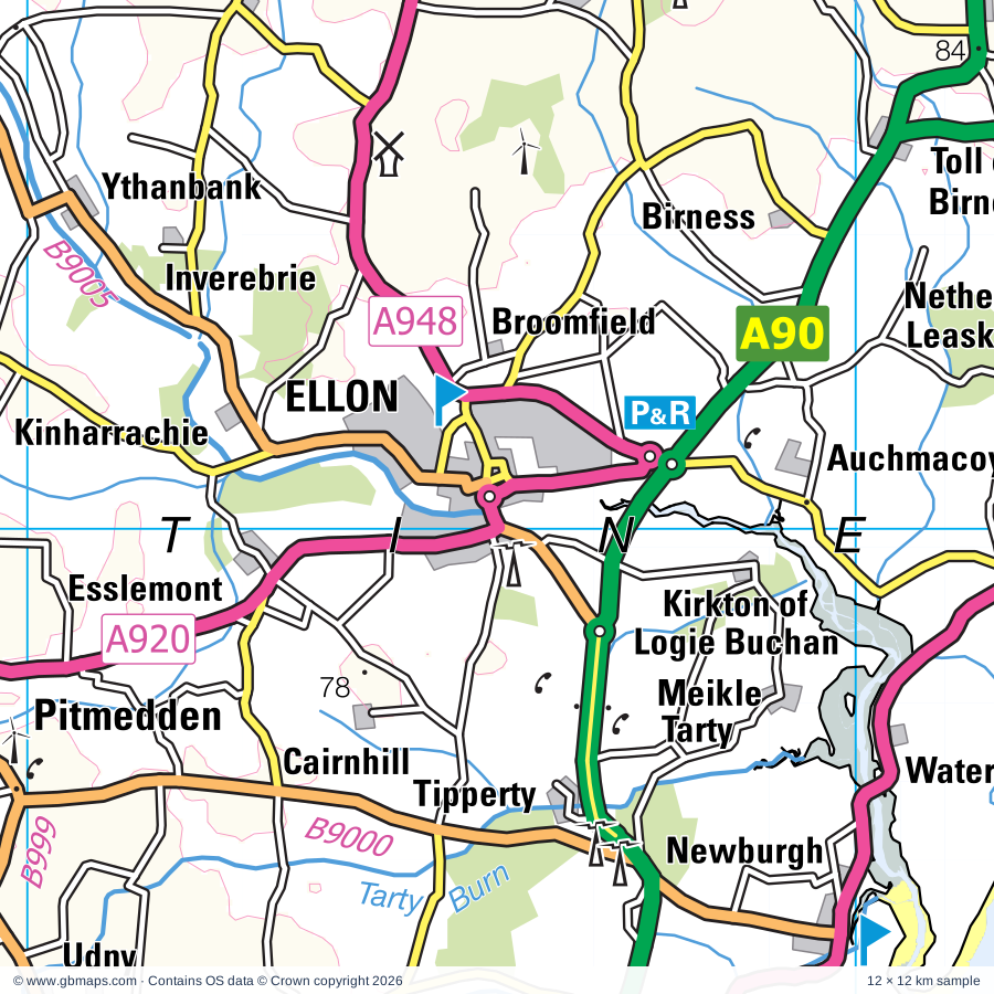
Explore the full 60 × 60 km Ellon regional road map at 1:250,000, covering Oldmeldrum, Turriff, Inverurie, Peterhead, Rosehearty. Compare the complete coverage below; a detailed PDF sample is available free.

ELLON & SURROUNDING AREAREGIONAL ROAD MAP
60 × 60 km · Full map previewDownload the free SVG ↓

INSIDE THE FULL 60 × 60 KM MAP

Explore the Ellon map area

1:250,000 cartography

Towns, villages & places

More mapped places (153)
  • Ardo
  • Ythanbank
  • Drymuir
  • Fortrie
  • Arthrath
  • Culsh
  • Cottown
  • Maud
  • Hillbrae
  • Wedderlairs
  • Millbrex
  • Skelmuir
  • Kinharrachie
  • Ythsie
  • Tarves
  • Stuartfield
  • Muirtack
  • Lethenty
  • Fedderate
  • Monkshill
  • Clola
  • Kinknockie
  • Backhill
  • Esslemont
  • Old Deer
  • Craigdam
  • Woodhead
  • Ardallie
  • Millbreck
  • Smallburn
  • Ironside
  • Oldwhat
  • Tifty
  • Pitmedden
  • Mintlaw
  • St Katherines
  • Balthangie
  • Fetterangus
  • Fyvie
  • Cuminestown
  • Bonnykelly
  • Tipperty
  • Inverythan
  • Tarty
  • Hatton
  • Garmond
  • Denhead
  • Longside
  • Cultercullen
  • Pettymuick
  • Strichen
  • Waterside
  • Whitefield
  • Hattoncrook
  • Flushing
  • Jackstown
  • Whiterashes
  • Fingask
  • Foveran
  • Dykeside
  • Newburgh
  • Collieston
  • Rothienorman
  • Gordonstown
  • Whinnyfold
  • Rora
  • Daviot
  • Cruden Bay
  • Hillbrae
  • Middlemuir
  • Newburgh
  • Newmachar
  • Craigie
  • Kingseat
  • Inverugie
  • Balhalgardy
  • Tocher
  • Kinmuck
  • Sandfordhill
  • Durno
  • Netherbrae
  • Whitecairns
  • Kinmundy
  • Lonmay
  • Boyndlie
  • Kirktown
  • Gariochsford
  • Whiteford
  • Plaidy
  • Crimond
  • Kirkton
  • Belhelvie
  • Tyrie
  • St Fergus
  • Pitcaple
  • Rathen
  • Balmedie
  • Boddam
  • Fisherford
  • Memsie
  • Drumligair
  • Bonnyton
  • Fortrie
  • Balgaveny
  • Gorrachie
  • Cothal
  • Cairnhill
  • Bogton
  • Old Rayne
  • Carnousie
  • King Edward
  • Pitmachie
  • Pennan
  • Clovenstone
  • Auchininna
  • Peathill
  • Blackdog
  • Aucharnie
  • Gardenstown
  • Burnhervie
  • Ythanwells
  • Aquhythie
  • Oyne
  • Colpy
  • Crovie
  • Keilhill
  • Longmanhill
  • St Combs
  • Cottown
  • Sandhaven
  • Inverkeithny
  • Bograxie
  • Pittulie
  • Muir of Kinellar
  • Inverallochy
  • Kemnay
  • Corse
  • Insch
  • Kirkton
  • Forgue
  • Grantlodge
  • Blairdaff
  • Largie
  • Craigearn
  • Auchleven
  • Monymusk
  • Sauchen
  • Keig
  • Boyndie
  • Whitehills
  • Ordhead
  • Tillyfourie
  • Whitehouse

Roads across this sheet

A95, A97, A98, A920, A944, A947, A948, A950, A952, A956, A975, A981, A982, B973, B977, B979, B987, B992, B993, B994, B997, B999, B9000, B9001

More road numbers

B9002, B9003, B9005, B9023, B9024, B9025, B9026, B9027, B9028, B9029, B9030, B9031, B9032, B9033, B9034, B9038, B9093, B9105, B9106, B9107, B9108, B9117, B9121, B9123, B9126, B9139, B9142, B9170

Rivers & waterways

Burn of Boyne, Foveran Burn, Gadie Burn, Little Water, North Ugie Water, River Deveron, River Don, River Ugie, River Urie, River Ythan, South Ugie Water, Tarty Burn

Landmarks & landscape

Aden Aberdeenshire Farming Museum, Aden Country Park, Arbuthnot Museum and Art Gallery, Ardno House, Balbithan House, Balmedie Country Park, Banff Museum, Barra Castle, Brandsbutt Stone, Bridge of Alvah, Bullers of Buchan (Gorge), Cairnbanno House

More named features

Cairnbulg Castle, Castle, Castle Forbes, Castle Fraser, Castle Fraser Garden and Estate, Cluny Castle, Craigston Castle, Culsh Monument, Cycle Trails, Deer Abbey, Delgatie Castle, Delgaty Castle, Drinnie's Wood Observatory, Duff House, Easter Aquhorthies Stone Circle, Forglen House, Formartines Visitor Centre, Forvie Centre (Visitor Centre), Forvie National Nature Reserve, Fyvie Castle, Glen Garioch Distillery, Glen Garioch Distillery & Visitor Centre, Glendronach Distillery, Haddo Country Park, Haddo House, Haddo House Garden, Harlaw Monument, Hatton Castle, Keith Hall, Kemnay Quarry Sculptured Hill, Kinkell Church, Kirkhill Forest Wayfaring Course, Lickleyhead Castle, Loanhead of Daviot Stone Circle, Loch of Strathbeg Nature Reserve, Macduff Distillery, Macduff Marine Aquarium, Maggie's Hoosie, Maiden Stone, Manar House, Maud Railway Museum, Meldrum House, Memsie Burial Cairn, Montcoffer House, Mormond Horse, Mormond Stag, Mormond Stag (Hill Figure), Mormond White Horse (Hill Figure), Mounie Castle, Mounthooly Doocot, Museum of Farming Life, Newton House, Parkhill House, Picardy Symbol Stone, Pillodrie House, Pitmedden Gardens, Pitsligo Castle, Session Cottage, Old Post Office, Slains Castle, Tarves Medieval Tomb, The Insch Connection Museum, The Museum of Scottish Lighthouses, Fraserburgh Hertiage Centre, Tolquhon Castle, Towie Barclay Castle, Visitor Centre, Waters of Philorth Local Nature Reserve, Willows
Local authority & parish coverage

Wholly or partly within the full map rectangle. These boundaries are coverage information, not additional artwork layers.

  • Aberdeen CityPartly within
  • AberdeenshirePartly within
  • MorayPartly within
Wards & electoral divisions 17 areas
  • Banff and District Ward (part)
  • Bridge of Don Ward (part)
  • Central Buchan Ward
  • Dyce/Bucksburn/Danestone Ward (part)
  • East Garioch Ward (part)
  • Ellon and District Ward
  • Fraserburgh and District Ward
  • Huntly, Strathbogie and Howe of Alford Ward (part)
  • Inverurie and District Ward
  • Keith and Cullen Ward (part)
  • Mid Formartine Ward
  • Peterhead North and Rattray Ward
  • Peterhead South and Cruden Ward
  • Troup Ward
  • Turriff and District Ward (part)
  • West Garioch Ward (part)
  • Westhill and District Ward (part)
Civil parishes & communities 0 areas

    Source: the GBMaps road atlas, OS Boundary-Line and postcode mapping datasets. Source editions are being checked for publication. Unmarked boundary names are wholly within the sheet; “part” means the map edge crosses the area.

    Place lists are selected from the map source, not a complete gazetteer. Named features describe the cartography; visitor facilities and opening status are not verified. The free sample covers only 12 × 12 km of this larger sheet.

    INSIDE YOUR DOWNLOAD

    A proper road map, in useful formats

    Road classifications, towns and villages, railways, rivers, landscape detail and tourist symbols, brought together in the GBMaps regional road atlas style.

    PDF filePDFSVG fileSVGAdobe Illustrator AI fileAi

    PDF for the finished map. SVG and layered Illustrator artwork for adapting colours, adding your own information and preparing designs.

    THE FINISHED SHEET

    Designed for print and presentation

    Map coverage
    60 × 60 km
    Sample coverage
    12 × 12 km
    Print layout
    A3 landscape · enlarged 1:250k cartography
    Sheet furniture
    Border, scale bar, key & north arrow

    A few useful details

    What changes when I select another square?

    Select a surrounding square to bring it into the centre and reveal the maps around it. Each square is a different 60 × 60 km map. The preview, free sample and selected download change together. Neighbouring sheets overlap by 30 km so you can choose the coverage that suits you.

    Is the free sample a vector map?

    The on-page detail is an SVG. The free download is a separate 12 × 12 km PDF with a link to the full map. Please retain its copyright credits and product link when sharing it.

    Can I buy a larger combined map?

    These downloads are individual ready-made sheets. Contact GBMaps if you need a larger combined area.

    FREE PDF SAMPLE

    Your free map sample

    Your free 12 × 12 km sample includes a link back to this map, so you can return for the full area whenever you need it.

    Download free PDF sample ↓

    Get your Ellon map

    Map download bundle

    £24.00including VATOne payment

    Pay securely

    One payment. Your map stays open.

    Your map download

    Your map files

    Preparing your download…

    Checking your private download link…

    Your map downloads

    Already bought a map?

    Find the downloads from your purchases.

    Enter the email address you used at checkout. We’ll email you a private link to your available map downloads.