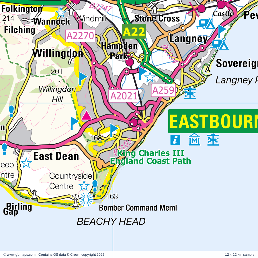
Eastbourne regional road map. Full 60 × 60 km PDF, SVG and Illustrator files, with a free PDF sample.

GBMAPS.COM

Eastbourne Regional Road Map

Call Us Now for Help01751 473136

GREAT BRITAIN ROAD ATLAS · 1:250,000 GB-570-0090

Eastbourne & surrounding area

Explore the full 60 × 60 km Eastbourne regional road map at 1:250,000, covering Polegate, Hailsham, Hastings, Seaford, Battle. Compare the complete coverage below; a detailed PDF sample is available free.

EASTBOURNE & SURROUNDING AREAREGIONAL ROAD MAP
60 × 60 km · Full map previewDownload the free SVG ↓

INSIDE THE FULL 60 × 60 KM MAP

Explore the Eastbourne map area

1:250,000 cartography

Towns, villages & places

More mapped places (70)
  • Wartling
  • Folkington
  • Westdean
  • Hooe Common
  • Lunsford's Cross
  • Wilmington
  • Litlington
  • Alfriston
  • Ninfield
  • Henley's Down
  • Crowhurst
  • Arlington
  • Herstmonceux
  • Berwick
  • Catsfield
  • Stunts Green
  • Hellingly
  • Bishopstone
  • Telham
  • Selmeston
  • Cowbeech
  • Chalvington
  • Penhurst
  • Fairlight
  • Ripe
  • Westfield
  • Fairlight Cove
  • South Heighton
  • Netherfield
  • Firle
  • Chiddingly
  • Tarring Neville
  • Sedlescombe
  • Burlow
  • Dallington
  • Whitesmith
  • Whatlington
  • Warbleton
  • Piddinghoe
  • Pett
  • Vines Cross
  • Horam
  • Mountfield
  • Laughton
  • Glynde
  • Brede
  • Beddingham
  • Maynard's Green
  • Southease
  • Icklesham
  • Glyndebourne
  • Rodmell
  • Telscombe
  • Shortgate
  • Broadland Row
  • Waldron
  • Halland
  • Broyle Side
  • Iford
  • Udimore
  • Ringmer
  • Winchelsea Beach
  • Winchelsea
  • Hamsey
  • Offham
  • Barcombe
  • Isfield
  • Cooksbridge
  • Spithurst
  • Camber

Roads across this sheet

A21, A22, A26, A28, A259, A267, A269, A271, A275, A277, A295, A2021, A2029, A2036, A2040, A2100, A2101, A2102, A2270, A2280, A2290, A2690, B2089, B2090

More road numbers

B2092, B2093, B2095, B2096, B2098, B2103, B2104, B2106, B2109, B2124, B2159, B2182, B2191, B2192, B2193, B2203, B2204, B2244, B2247

Rivers & waterways

Cuckmere River, River Brede, River Ouse, River Tillingham, Royal Military Canal, Waller's Haven

Landmarks & landscape

Abbotswood Nature Reserve, Alfriston Clergy House, Anne of Cleves House, Barbican House Museum, Arlington Reservoir Nature Reserve, Ashburnham Place, Battle Abbey (remains of), Battle Abbey Visitor Centre, Beachy Head Countryside Centre, Bentley Motor Museum, Bexhill Museum, Blackberry Farm, Blue Reef Aquarium, SOUTH DOWNS NATIONAL PARK

More named features

Camber Castle, Carr Taylor Vineyard, Charleston Farmhouse, Combe Valley Countryside Park, Crypt Gallery, Drusilla Zoo, Eastbourne Miniature Steam Railway Park, Firle Place, Fore Wood Nature Reserve, Fort Fun, Glynde Place, Greenwich Meridian Memorial, Guestling Wood Nature Reserve, Hastings Castle, Hastings Country Park, Hastings Museum and Art Gallery, Shipwreck Heritage Centre, Museum of Local History, Flower Manufacturing Museum, Fishermen's Museum, Herstmonceux Castle, Herstmonceux Castle Gardens, Hidden Spring Vineyard, Holmes Hill Estate, Kitty Hawk Solar Farm, Knockhatch Adventure Park, Lavender Line (Tourist Railway), Lewes Castle, Litlington Horse, Lullington Heath Nature Reserve, Manor Barn House, Michelham Priory (remains of), Michelham Priory Watermill, Middle Farm Countryside Centre, Monk's House, Motoring Heritage Gallery, Museums of Local History, Yesterdays World, Newhaven Fort, Newhaven Fort, Scuba Centre, Newhaven Local and Maritime Museum, Paradise Family Leisure Park, Pett Pools Nature Reserve, Pevensey Castle, Pevensey Levels Nature Reserve, Polegate Windmill, Raystede Centre for Animal Welfare, Rye Harbour Nature Reserve, Rye Watersports, Seaford Museum of Local History, Seven Sisters Country Park, Seven Sisters Sheep Centre, Seven Sisters Visitor Centre, Spring Barn Farm Park, St Mary in the Castle Arts Centre, Hastings Miniature Railway, West Hill Cliff Railway, Jerwood Gallery, The Bradness Gallery, The Flamingo Family Fun Park, The Long Man of Wilmington, The Long Man of Wilmington (Hill Figure), The Observatory Science Centre, The Pottery, The Redoubt, RNLI Lifeboat Museum, Museum of Shops, Eastbourne Heritage Centre, Tresure Island, Warrior Square Gardens, Wellingham Walled Herb Garden, Winchelsea Museum, Ypres Tower Museum, Rye Castle Museum, Rye Treasury of Mechanical Music
Local authority & parish coverage

Wholly or partly within the full map rectangle. These boundaries are coverage information, not additional artwork layers.

  • Eastbourne DistrictWholly within
  • Folkestone and Hythe DistrictPartly within
  • Hastings DistrictWholly within
  • Lewes DistrictPartly within
  • Rother DistrictPartly within
  • Wealden DistrictPartly within
Wards & electoral divisions 87 areas
  • Arlington Ward
  • Ashdown Ward
  • Baird Ward
  • Bexhill Central Ward
  • Bexhill Collington Ward
  • Bexhill Kewhurst Ward
  • Bexhill Old Town & Worsham Ward
  • Bexhill Pebsham & St. Michaels Ward
  • Bexhill Sackville Ward
  • Bexhill Sidley Ward
  • Bexhill St. Marks Ward
  • Bexhill St. Stephens Ward
  • Braybrooke Ward
  • Brede & Udimore Ward (part)
  • Burwash & the Weald Ward (part)
  • Castle Ward
  • Catsfield & Crowhurst Ward (part)
  • Central St. Leonards Ward
  • Chailey, Barcombe & Hamsey Ward (part)
  • Chiddingly, East Hoathly & Waldron Ward (part)
  • Conquest Ward
  • Danehill & Fletching Ward (part)
  • Devonshire Ward
  • East Saltdean & Telscombe Cliffs Ward (part)
  • Eastern Rother Ward (part)
  • Framfield & Cross-in-Hand Ward (part)
  • Gensing Ward
  • Hailsham Central Ward
  • Hailsham East Ward
  • Hailsham North Ward
  • Hailsham North West Ward
  • Hailsham South Ward
  • Hailsham West Ward
  • Hampden Park Ward
  • Heathfield South Ward (part)
  • Hellingly Ward
  • Herstmonceux & Pevensey Levels Ward
  • Hollington Ward
  • Horam & Punnetts Town Ward (part)
  • Kingston Ward (part)
  • Langney Ward
  • Lewes Bridge Ward
  • Lewes Castle Ward
  • Lewes Priory Ward (part)
  • Lower Willingdon Ward
  • Maze Hill Ward
  • Meads Ward
  • Newhaven North Ward
  • Newhaven South Ward
  • Newick Ward (part)
  • North Battle, Netherfield & Whatlington Ward (part)
  • Northern Rother Ward (part)
  • Old Hastings Ward
  • Old Town Ward
  • Ore Ward
  • Ouse Valley & Ringmer Ward
  • Peacehaven East Ward
  • Peacehaven North Ward
  • Peacehaven West Ward
  • Pevensey Bay Ward
  • Polegate Central Ward
  • Polegate North Ward
  • Polegate South & Willingdon Watermill Ward
  • Ratton Ward
  • Rye & Winchelsea Ward (part)
  • Seaford Central Ward
  • Seaford East Ward
  • Seaford North Ward
  • Seaford South Ward
  • Seaford West Ward
  • Sedlescombe & Westfield Ward (part)
  • Silverhill Ward
  • South Battle & Telham Ward
  • South Downs Ward
  • Southern Rother Ward
  • Sovereign Ward
  • St. Anthony's Ward
  • St. Helens Ward
  • Stone Cross Ward
  • Tressell Ward
  • Uckfield New Town Ward (part)
  • Uckfield Ridgewood & Little Horsted Ward (part)
  • Upper Willingdon Ward
  • Upperton Ward
  • Walland & Denge Marsh Ward (part)
  • West St. Leonards Ward
  • Wishing Tree Ward
Civil parishes & communities 74 areas
  • Alciston CP
  • Alfriston CP
  • Arlington CP
  • Ashburnham CP
  • Barcombe CP
  • Battle CP (part)
  • Beckley CP (part)
  • Beddingham CP
  • Berwick CP
  • Bexhill-on-Sea CP
  • Brede CP (part)
  • Brightling CP (part)
  • Burwash CP (part)
  • Camber CP (part)
  • Catsfield CP
  • Chailey CP (part)
  • Chalvington with Ripe CP
  • Chiddingly CP
  • Crowhurst CP
  • Cuckmere Valley CP
  • Dallington CP (part)
  • East Dean and Friston CP
  • East Guldeford CP (part)
  • East Hoathly with Halland CP
  • Fairlight CP
  • Firle CP
  • Framfield CP (part)
  • Glynde CP
  • Guestling CP
  • Hailsham CP
  • Hamsey CP (part)
  • Heathfield and Waldron CP (part)
  • Hellingly CP
  • Herstmonceux CP
  • Hooe CP
  • Horam CP
  • Icklesham CP
  • Iford CP (part)
  • Isfield CP (part)
  • Ivychurch CP (part)
  • Kingston Near Lewes CP (part)
  • Laughton CP
  • Lewes CP (part)
  • Little Horsted CP (part)
  • Long Man CP
  • Mountfield CP (part)
  • Newhaven CP
  • Newick CP (part)
  • Ninfield CP
  • Peacehaven CP
  • Peasmarsh CP (part)
  • Penhurst CP
  • Pett CP
  • Pevensey CP
  • Piddinghoe CP
  • Polegate CP
  • Ringmer CP
  • Rodmell CP (part)
  • Rye CP (part)
  • Seaford CP
  • Sedlescombe CP (part)
  • Selmeston CP
  • South Heighton CP
  • Southease CP
  • Tarring Neville CP
  • Telscombe CP (part)
  • Uckfield CP (part)
  • Udimore CP (part)
  • Warbleton CP (part)
  • Wartling CP
  • Westfield CP
  • Westham CP
  • Whatlington CP (part)
  • Willingdon and Jevington CP

Source: the GBMaps road atlas, OS Boundary-Line and postcode mapping datasets. Source editions are being checked for publication. Unmarked boundary names are wholly within the sheet; “part” means the map edge crosses the area.

Place lists are selected from the map source, not a complete gazetteer. Named features describe the cartography; visitor facilities and opening status are not verified. The free sample covers only 12 × 12 km of this larger sheet.

INSIDE YOUR DOWNLOAD

A proper road map, in useful formats

Road classifications, towns and villages, railways, rivers, landscape detail and tourist symbols, brought together in the GBMaps regional road atlas style.

PDF filePDFSVG fileSVGAdobe Illustrator AI fileAi

PDF for the finished map. SVG and layered Illustrator artwork for adapting colours, adding your own information and preparing designs.

THE FINISHED SHEET

Designed for print and presentation

Map coverage
60 × 60 km
Sample coverage
12 × 12 km
Print layout
A3 landscape · enlarged 1:250k cartography
Sheet furniture
Border, scale bar, key & north arrow

A few useful details

What changes when I select another square?

Select a surrounding square to bring it into the centre and reveal the maps around it. Each square is a different 60 × 60 km map. The preview, free sample and selected download change together. Neighbouring sheets overlap by 30 km so you can choose the coverage that suits you.

Is the free sample a vector map?

The on-page detail is an SVG. The free download is a separate 12 × 12 km PDF with a link to the full map. Please retain its copyright credits and product link when sharing it.

Can I buy a larger combined map?

These downloads are individual ready-made sheets. Contact GBMaps if you need a larger combined area.

FREE PDF SAMPLE

Your free map sample

Your free 12 × 12 km sample includes a link back to this map, so you can return for the full area whenever you need it.

Download free PDF sample ↓

Get your Eastbourne map

Map download bundle

£24.00including VATOne payment

Pay securely

One payment. Your map stays open.

Your map download

Your map files

Preparing your download…

Checking your private download link…

Your map downloads

Already bought a map?

Find the downloads from your purchases.

Enter the email address you used at checkout. We’ll email you a private link to your available map downloads.