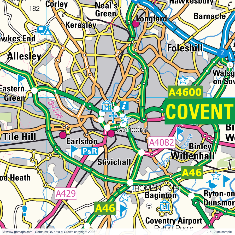
Coventry regional road map. Full 60 × 60 km PDF, SVG and Illustrator files, with a free PDF sample.

GBMAPS.COM

Coventry Regional Road Map

Call Us Now for Help01751 473136

GREAT BRITAIN ROAD ATLAS · 1:250,000 GB-450-0270

Coventry & surrounding area

Explore the full 60 × 60 km Coventry regional road map at 1:250,000, covering Rugby, Daventry, Southam, Lutterworth, Whitnash. Compare the complete coverage below; a detailed PDF sample is available free.

COVENTRY & SURROUNDING AREAREGIONAL ROAD MAP
60 × 60 km · Full map previewDownload the free SVG ↓

INSIDE THE FULL 60 × 60 KM MAP

Explore the Coventry map area

1:250,000 cartography

Towns, villages & places

More mapped places (322)
  • Sawbridge
  • Barby
  • Draycote
  • Hill
  • Braunston
  • Kilsby
  • Broadwell
  • Flecknoe
  • Frankton
  • Newton
  • Stockton
  • Marton
  • Welton
  • Cosford
  • Crick
  • Lilbourne
  • Staverton
  • Catthorpe
  • Princethorpe
  • Bretford
  • Wolston
  • Easenhall
  • Watford
  • Eathorpe
  • Shawell
  • Churchover
  • Upper Catesby
  • Brandon
  • Yelvertoft
  • Bascote
  • Brinklow
  • Swinford
  • Norton
  • Long Buckby Wharf
  • Wappenbury
  • Pailton
  • Hellidon
  • Clay Coton
  • Badby
  • Stanford on Avon
  • Cotesbach
  • Hunningham
  • Newnham
  • Winwick
  • Bubbenhall
  • Ladbroke
  • Charwelton
  • Ufton
  • Offchurch
  • Whilton
  • Dodford
  • Willey
  • Misterton
  • Brockhall
  • Walcote
  • Everdon
  • Stareton
  • Cubbington
  • Withybrook
  • Baginton
  • Harbury
  • Ansty
  • Ravensthorpe
  • Weedon Bec
  • Byfield
  • East Haddon
  • Wormleighton
  • Stoneleigh
  • Bitteswell
  • Flore
  • Shilton
  • Coton
  • Guilsborough
  • Ullesthorpe
  • Wibtoft
  • Welford
  • Hinton
  • Barnacle
  • Thornby
  • Knightcote
  • Kimcote
  • Nobottle
  • Farthingstone
  • Chesterton
  • Ashow
  • Hollowell
  • Wolvey
  • Aston le Walls
  • Gilmorton
  • Teeton
  • Walton
  • Wolvey Heath
  • Upper Stowe
  • Holdenby
  • Hill Wootton
  • Bulkington
  • Eydon
  • Old Milverton
  • Hawkesbury
  • Claydon
  • Leire
  • Northend
  • Naseby
  • Litchborough
  • Maidford
  • Frolesworth
  • Creaton
  • Adstone
  • Harlestone
  • Chipping Warden
  • Harpole
  • Gaydon
  • Farnborough
  • Lighthorne
  • Cottesbrooke
  • Ashby Magna
  • Bugbrooke
  • Spratton
  • Sibbertoft
  • Sharnford
  • Edgcote
  • Grimscote
  • Kislingbury
  • Bruntingthorpe
  • Haselbech
  • Theddingworth
  • Chadshunt
  • Ashorne
  • Pattishall
  • Blakesley
  • Mollington
  • Griff
  • Sapcote
  • Culworth
  • Cropredy
  • Bermuda
  • Wardington
  • Burton Green
  • Hawkes End
  • Woodend
  • Mowsley
  • Warmington
  • Clipston
  • Eastcote
  • Longbridge
  • Shearsby
  • Barford
  • Astcote
  • Williamscot
  • Brixworth
  • Laughton
  • Weston
  • Budbrooke
  • Corley
  • Rothersthorpe
  • Kineton
  • Sherbourne
  • Sulgrave
  • Arnesby
  • Radway
  • Cosby
  • Kelmarsh
  • Ratley
  • Shotteswell
  • Pitsford
  • Beausale
  • Little Kineton
  • Croft
  • Boughton
  • Honiley
  • Gayton
  • Wasperton
  • Duncote
  • Maidwell
  • Edgehill
  • Bradden
  • Corley Ash
  • Chacombe
  • Greens Norton
  • Wellesbourne
  • Lamport
  • Combrook
  • Hatton Green
  • Elmesthorpe
  • Countesthorpe
  • Lubenham
  • Tiffield
  • Gumley
  • Draughton
  • Scaldwell
  • Charlecote
  • Berkswell
  • Astley
  • Hornton
  • Hanwell
  • Saddington
  • Slapton
  • Littlethorpe
  • Barwell
  • Wappenham
  • Horley
  • Huncote
  • Wroxall
  • Walton
  • Helmdon
  • Chapel Green
  • Fleckney
  • Narborough
  • Arthingworth
  • Hatton
  • Fillongley
  • Abthorpe
  • Greatworth
  • Whetstone
  • Blisworth
  • Kilby
  • Higham on the Hill
  • Thenford
  • Foxton
  • Moulton
  • New Arley
  • Meriden
  • Shrewley
  • Hulcote
  • Blaby
  • Old
  • Collingtree
  • Drayton
  • Thurlaston
  • Caldecote
  • Holcot
  • Lower Tysoe
  • Overthorpe
  • Stapleton
  • Harrington
  • Wroxton
  • Hartshill
  • Enderby
  • Dadlington
  • Rowington
  • Alveston
  • Alkerton
  • Loxley
  • Rowington Green
  • Old Arley
  • Wood Burcote
  • Ansley
  • Shenington
  • Wolverton
  • Halse
  • Braybrooke
  • Oxhill
  • Shutlanger
  • Balscote
  • Snitterfield
  • Barston
  • Crowfield
  • Radstone
  • Fenny Drayton
  • Oldbury
  • Wigston
  • Courteenhall
  • Upper Tysoe
  • Syresham
  • Silverstone
  • Ingon
  • Tiddington
  • Ettington
  • Maxstoke
  • Roade
  • Shutford
  • Fulready
  • Pury End
  • Witherley
  • Dingley
  • Whittlebury
  • Whatcote
  • Mancetter
  • Birchley Heath
  • Tur Langton
  • Upton
  • Biddlesden
  • Epwell
  • Paulerspury
  • Ashton
  • Idlicote
  • Alderton
  • Bentley
  • Shangton
  • Sutton Bassett
  • Winderton
  • Halford
  • Shustoke
  • Alderminster
  • Hartwell
  • Welham
  • Crimscote
  • Baxterley
  • Weston by Welland
  • Wimpstone
  • Tredington
  • Glooston
  • Armscote
  • Cranoe
  • Ashley
  • Honington
  • Hurley
  • Slawston
  • Blackwell
  • Grendon
  • Potterspury
  • Noseley
  • Admington
  • Goadby
  • Marston
  • Darlingscott
  • Kingsbury
  • Ilmington
  • Castlethorpe
  • Hallaton
  • Cosgrove
  • Old Stratford

Roads across this sheet

M1, M6, M40, M42, M45, M69, A6, A43, A45, A47, A51, A361, A413, A422, A423, A425, A426, A427, A428, A429, A439, A444, A445, A446

More road numbers

A447, A452, A455, A508, A563, A3400, A4053, A4071, A4082, A4097, A4114, A4141, A4177, A4189, A4254, A4256, A4260, A4303, A4304, A4390, A4500, A4501, A4600, A5076, A5095, A5101, A5123, A5199, B526, B576, B578, B581, B582, B590, B664, B669, B4029, B4035, B4036, B4037, B4038, B4065, B4076, B4082, B4086, B4087, B4098, B4099, B4100, B4101, B4102, B4103, B4104, B4106, B4107, B4109, B4110, B4111, B4112, B4113, B4114, B4115, B4116, B4117, B4118, B4428, B4429, B4439, B4451, B4452, B4453, B4455, B4463, B4525, B4544, B4632, B4642, B4666, B4667, B4668, B4669, B5346, B5366, B5383, B5385, B5414, B5418, B6047

Rivers & waterways

Ashby-de-la-Zouch Canal, Birmingham & Fazeley Canal, Canal, Canal (disused), Coventry Canal, Grand Union Canal, Oxford Canal, River Anker, River Avon, River Blythe, River Cherwell, River Cole

More waterways

River Great Ouse, River Ise, River Leam, River Nene, River Sence, River Soar, River Sowe, River Stour, River Swift, River Tame, River Tove, River Welland, Stratford-upon-Avon Canal

Landmarks & landscape

Abbey, Abington Museum, Althorp, Arbury, Art Centre, Banbury Museum and Tooleys Boatyard, Barnes Meadow Nature Reserve, Berkswell Village Museum, Berkswell Windmill, Brampton Valley Way, Brandon Marsh Nature Reserve, British Aviation Heritage Museum

More named features

Brixworth Country Park, Brixworth Country Park Visitor Centre, Brocks Hill Country Park and Visitor Centre, Brook Cottage Garden, Burbage Common and Woods Local Nature Reserve, Burnums Farmyard Museum, Burton Dassett Hills Country Park, Bygones Museum, Canons Ashby, Carpetbagger Museum, Northants Aviation Museum, Catanger Farm, Catanger Llamas, Cathedral of Our Lady and St Thomas of Canterbury Martyr, Central Museum & Art Gallery, 78 Derngate (The Charles Rennie Mackintosh House and Galleries, Charlecote Mill, Charlecote Park, Chilvers Coton Craft Centre, Compton Verney House, Compton Verney House with major art gallery, Compton Wynyates, Coombe Abbey, Coombe Valley Country Park, Coton Manor Gardens, Cottesbrooke Hall, Cottesbrooke Hall Gardens, Coventry Cathedral, Cross, Daventry Country Park, Delapre Abbey, Draycote Water Visitor Centre, Everdon Stubbs Woodland Trust Wood Nature Reserve, Farnborough Hall, Foxton Canal Museum, Foxton Locks Country Park, Gilberts Rugby Football Museum, Rugby School Museum, Great Central Railway Nature Reserve, Hallaton Village Museum, Harborough Museum, Hartshill Hayes Country Park, Hartshill Hayes Country Park Woodland Nature Reserve, Hatton Country World, Heart of England Adventure Park Activity Centre, Heritage Motor Centre, Hinkley and District Museum, Hoar Park Children's Farm, Honington Hall, Hunsbury Hill Country Park, Kelmarsh Hall, Kelmarsh Hall and Gardens, Kenilworth Castle, Kingsbury Water Park, Lamport Hall, Leamington Spa Art Gallery & Museum, Long Buckby Castle, Lutterworth Museum, Meriden Cross, Midland Air Museum, Museum of British Road Transport, Museum of Country Bygones, National Herb Centre, National Motorcycle Museum, National Waterways Museum, Stoke Bruerne, New Place & Nash's House, Shakespeare's Birtplace, Anne Hathaway's Cottage, Hall's Croft, Harvard House, Newbold Comyn Park, Northampton & Lamport Railway (Preserved Railway), Northamptonshire Ironstone Railway Museum, Nuneaton Museum and Art Gallery, Old Dairy Farm Centre, Priory Gardens Visitor Centre, Rainsbrook Valley Miniature Railway, Redwings Horse Sanctuary, Rookery Farm (Working Farm), Royal Shakespeare Theatre, Ryton Organic Gardens, Ryton Pools, Ryton Pools Country Park Visitor Centre, Saltisford Canal Centre, Shacks Barn Solar Farm, Shakespearience, Shakespeare's Birthplace Museum, Hall's Croft Museum, The Falstaff Experience, Silverstone Motor Racing Circuit, Spiceball Country Park, St Johns Museum, Warwickshire Museum, The Queens Own Hussars Museum, Warks Yeomanry & Warwick Town Museum, Stanford Hall, Startford Butterfly Farm, Stoneleigh Abbey, Stoneleigh Park Showground, Stony Stratford Nature Reserve, Sulgrave Manor, The Lunt (Restored Roman Fort), The Lunt Roman Fort, The Mill Arts Centre, Towcester Racecourse, Upton House, Victoria Park, Visitor Centre, Warwick Castle, Warwick Racecourse, Warwickshire Exhibition Centre, Welcombe Hills Country Park, Welcombe Hills Local Nature Reserve, Wellesbourne Airfield Museum, Wellesbourne Watermill, Whilton Locks Pottery, Whilton Mill, Wigston Framework Knitters Museum, Wigston Museum, Wistow Rural Centre, Wroxton Abbey, Wyken Croft Nature Park
Local authority & parish coverage

Wholly or partly within the full map rectangle. These boundaries are coverage information, not additional artwork layers.

  • Blaby DistrictPartly within
  • BuckinghamshirePartly within
  • Cherwell DistrictPartly within
  • City of LeicesterPartly within
  • Cotswold DistrictPartly within
  • Coventry DistrictWholly within
  • Harborough DistrictPartly within
  • Hinckley and Bosworth DistrictPartly within
  • Lichfield DistrictPartly within
  • Milton KeynesPartly within
  • North NorthamptonshirePartly within
  • North Warwickshire DistrictPartly within
  • Nuneaton and Bedworth DistrictWholly within
  • Oadby and Wigston DistrictPartly within
  • Rugby DistrictWholly within
  • Solihull DistrictPartly within
  • Stratford-on-Avon DistrictPartly within
  • Tamworth DistrictPartly within
  • Warwick DistrictPartly within
  • West NorthamptonshirePartly within
Wards & electoral divisions 210 areas
  • Abington & Phippsville Ward
  • Admirals and Cawston Ward
  • Ambien Ward (part)
  • Arbury Ward
  • Arley and Whitacre Ward
  • Atherstone Central Ward
  • Atherstone North Ward
  • Atherstone South and Mancetter Ward
  • Attleborough Ward
  • Aylestone Ward (part)
  • Bablake Ward
  • Baddesley and Grendon Ward (part)
  • Balsall & Berkswell Ward
  • Banbury Cross & Neithrop Ward (part)
  • Banbury Grimsbury & Hightown Ward (part)
  • Banbury Hardwick Ward
  • Banbury Ruscote Ward (part)
  • Banbury, Calthorpe & Easington Ward (part)
  • Barwell Ward
  • Bede Ward
  • Benn Ward
  • Billesdon & Tilton Ward (part)
  • Billing Ward (part)
  • Bilton Ward
  • Binley & Willenhall Ward
  • Bishop's Itchington, Fenny Compton & Napton Ward
  • Bishop's Tachbrook Ward
  • Blaby Ward
  • Blockley Ward (part)
  • Bosworth Ward
  • Bourne Vale Ward (part)
  • Brailes & Compton Ward (part)
  • Braunston & Crick Ward
  • Brixworth Ward
  • Broughton Astley South & Leire Ward
  • Broughton Astley-Primethorpe & Sutton Ward
  • Buckingham Ward (part)
  • Budbrooke Ward
  • Bulkington Ward
  • Burbage Sketchley and Stretton Ward
  • Burbage St. Catherines and Lash Hill Ward
  • Camp Hill Ward
  • Campion Ward
  • Castle Ward
  • Cheylesmore Ward
  • Chilvers Coton Ward
  • Claverdon & Snitterfield Ward (part)
  • Clifton, Newton and Churchover Ward
  • Cogenhoe & The Houghtons Ward (part)
  • Coleshill North Ward (part)
  • Coleshill South Ward (part)
  • Cosby & South Whetstone Ward
  • Coton and Boughton Ward
  • Countesthorpe Ward
  • Cropredy, Sibfords & Wroxton Ward (part)
  • Cubbington & Leek Wootton Ward
  • Curdworth Ward (part)
  • Dallington Spencer Ward
  • Daventry North East Ward
  • Daventry North West Ward
  • Daventry South Ward
  • Deanshanger & Paulerspury Ward (part)
  • Desborough Ward (part)
  • Dordon Ward (part)
  • Dunsmore Ward
  • Dunton Ward
  • Duston Ward
  • Earl Shilton Ward
  • Earlsdon Ward
  • Eastboro Ward
  • Eastlands Ward
  • Enderby Ward (part)
  • Exhall Ward
  • Eyres Monsell Ward (part)
  • Far Cotton, Delapre & Briar Hill Ward
  • Fillongley Ward (part)
  • Fleckney Ward
  • Foleshill Ward
  • Fosse Highcross Ward
  • Fosse Normanton Ward (part)
  • Fosse Stoney Cove Ward
  • Galley Common Ward
  • Gaydon, Kineton & Upper Lighthorne Ward
  • Glen Parva Ward
  • Glen Ward (part)
  • Hackleton & Roade Ward (part)
  • Hanslope Ward (part)
  • Harbury Ward
  • Hartshill Ward
  • Headlands Ward
  • Heath Ward
  • Henley Ward
  • Hillmorton Ward
  • Hinckley Castle Ward
  • Hinckley Clarendon Ward
  • Hinckley De Montfort Ward
  • Hinckley Trinity Ward
  • Holbrooks Ward
  • Hunsbury Ward
  • Hurley and Wood End Ward (part)
  • Kenilworth Abbey & Arden Ward (part)
  • Kenilworth Park Hill Ward
  • Kenilworth St. John's Ward
  • Kibworths Ward
  • Kingsbury Ward
  • Kingsley & Semilong Ward
  • Kingsthorpe North Ward
  • Kingsthorpe South Ward
  • Knowle Ward (part)
  • Leam Valley Ward
  • Leamington Brunswick Ward
  • Leamington Clarendon Ward
  • Leamington Lillington Ward
  • Leamington Milverton Ward
  • Leamington Willes Ward
  • Leicester Forest & Lubbesthorpe Ward (part)
  • Long Buckby Ward
  • Long Marston Ward (part)
  • Longford Ward
  • Lower Stoke Ward
  • Lubenham Ward
  • Lutterworth East Ward
  • Lutterworth West Ward
  • Market Harborough-Great Bowden & Arden Ward
  • Market Harborough-Little Bowden Ward
  • Market Harborough-Logan Ward
  • Market Harborough-Welland Ward
  • Meriden & Arden Ward (part)
  • Middleton Cheney Ward (part)
  • Milby Ward
  • Misterton Ward
  • Moulton Ward (part)
  • Narborough & Littlethorpe Ward (part)
  • Naseby Ward
  • Nene Valley Ward
  • Nevill Ward (part)
  • New Bilton Ward
  • Newbold Verdon with Desford and Peckleton Ward (part)
  • Newbold and Brownsover Ward
  • North Whetstone Ward
  • Oadby Brocks Hill Ward (part)
  • Oadby St. Peter's Ward (part)
  • Oadby Woodlands Ward (part)
  • Paddox Ward
  • Parklands Ward
  • Poplar Ward
  • Quinton Ward (part)
  • Radford Semele Ward
  • Radford Ward
  • Revel and Binley Woods Ward
  • Rokeby and Overslade Ward
  • Rothwell & Mawsley Ward (part)
  • Rural North East Ward (part)
  • Rural South Northamptonshire Ward (part)
  • Sherbourne Ward
  • Shipston North Ward (part)
  • Shipston South Ward (part)
  • Slough Ward
  • South Wigston Ward
  • Southam East, Central & Stockton Ward
  • Southam North & Long Itchington Ward
  • Southam South Ward
  • Southam West Ward
  • St. Mary's Ward
  • St. Michael's Ward
  • St. Nicolas Ward
  • Stockingford East Ward
  • Stockingford West Ward
  • Stony Stratford Ward (part)
  • Stratford Avenue Ward (part)
  • Stratford Clopton Ward (part)
  • Stratford Guildhall & Bridgetown Ward (part)
  • Stratford Orchard Hill Ward (part)
  • Stratford Shottery Ward (part)
  • Stratford Tiddington Ward
  • Stratford Welcombe Ward (part)
  • Talavera Ward (part)
  • Tile Hill & Canley Ward
  • Towcester Ward
  • Tredington Ward (part)
  • Trinity Ward (part)
  • Twycross and Witherley with Sheepy Ward (part)
  • Tysoe Ward
  • Ullesthorpe Ward
  • Upper Stoke Ward
  • Upton Ward
  • Wainbody Ward
  • Warwick All Saints & Woodloes Ward
  • Warwick Aylesford Ward
  • Warwick Myton & Heathcote Ward
  • Warwick Saltisford Ward
  • Weddington Ward
  • Wellesbourne East & Rural Ward
  • Wellesbourne North & Rural Ward
  • Wellesbourne South Ward
  • Weston Favell & Abington Vale Ward (part)
  • Whitestone Ward
  • Whitnash Ward
  • Whoberley Ward
  • Wigston All Saints Ward
  • Wigston Fields Ward (part)
  • Wigston Meadowcourt Ward
  • Wigston St. Wolstan's Ward (part)
  • Wilnecote Ward (part)
  • Wolston and the Lawfords Ward
  • Wolverton Ward (part)
  • Wolvey and Shilton Ward
  • Woodford & Weedon Ward
  • Woodlands Ward
  • Wyken Ward
Civil parishes & communities 467 areas
  • Abthorpe CP
  • Admington CP (part)
  • Adstone CP
  • Alderminster CP
  • Alderton CP
  • Allesley CP
  • Althorp CP
  • Ansley CP
  • Ansty CP
  • Arley CP
  • Arnesby CP
  • Arthingworth CP
  • Ashby Magna CP
  • Ashby Parva CP
  • Ashby St. Ledgers CP
  • Ashley CP (part)
  • Ashow CP
  • Ashton CP
  • Astley CP
  • Aston Flamville CP
  • Aston Le Walls CP
  • Atherstone CP
  • Atherstone on Stour CP (part)
  • Avon Dassett CP
  • Badby CP
  • Baddesley Clinton CP (part)
  • Baddesley Ensor CP
  • Baginton CP
  • Balsall CP
  • Banbury CP (part)
  • Barby CP
  • Barcheston CP (part)
  • Barford CP
  • Barston CP (part)
  • Barwell CP
  • Baxterley CP
  • Beausale, Haseley, Honiley and Wroxall CP
  • Bentley CP
  • Berkswell CP
  • Bickenhill and Marston Green CP (part)
  • Biddlesden CP (part)
  • Billing CP (part)
  • Binley Woods CP
  • Birdingbury CP
  • Bishop's Itchington CP
  • Bishop's Tachbrook CP
  • Bitteswell with Bittesby CP
  • Blaby CP
  • Blackdown CP
  • Blakesley CP
  • Blaston CP (part)
  • Blisworth CP
  • Boddington CP
  • Boughton CP
  • Bourton CP
  • Bourton and Draycote CP
  • Bradden CP
  • Brailes CP (part)
  • Brampton Ash CP (part)
  • Brandon and Bretford CP
  • Braunston CP
  • Braybrooke CP
  • Brington CP
  • Brinklow CP
  • Brixworth CP
  • Brockhall CP
  • Broughton Astley CP
  • Bruntingthorpe CP
  • Bubbenhall CP
  • Budbrooke CP
  • Bugbrooke CP
  • Burbage CP
  • Burton Dassett CP
  • Burton Green CP
  • Burton Hastings CP
  • Burton Overy CP
  • Butlers Marston CP
  • Byfield CP
  • Caldecote CP
  • Canons Ashby CP
  • Carlton Curlieu CP
  • Castlethorpe CP (part)
  • Catesby CP
  • Catthorpe CP
  • Cawston CP
  • Chacombe CP
  • Chadshunt CP
  • Chadwick End CP (part)
  • Chapel Ascote CP
  • Charlecote CP
  • Charwelton CP
  • Chesterton and Kingston CP
  • Chipping Warden and Edgcote CP
  • Church Lawford CP
  • Church with Chapel Brampton CP
  • Churchover CP
  • Claverdon CP (part)
  • Clay Coton CP
  • Claybrooke Magna CP
  • Claybrooke Parva CP
  • Claydon with Clattercot CP
  • Clifford Chambers and Milcote CP (part)
  • Clifton upon Dunsmore CP
  • Clipston CP
  • Cold Ashby CP
  • Cold Higham CP
  • Coleshill CP (part)
  • Collingtree CP
  • Combe Fields CP
  • Combrook CP
  • Compton Verney CP
  • Compton Wynyates CP
  • Copston Magna CP
  • Corley CP
  • Cosby CP
  • Cosford CP
  • Cosgrove CP (part)
  • Cotesbach CP
  • Cottesbrooke CP
  • Countesthorpe CP
  • Courteenhall CP
  • Cranoe CP
  • Creaton CP
  • Crick CP
  • Croft CP
  • Cropredy CP
  • Cubbington CP
  • Culworth CP
  • Curdworth CP (part)
  • Dadlington & Sutton Cheney CP (part)
  • Daventry CP
  • Deanshanger CP (part)
  • Desborough CP (part)
  • Dingley CP
  • Dodford CP
  • Dordon CP (part)
  • Draughton CP
  • Drayton Bassett CP (part)
  • Drayton CP (part)
  • Dunchurch CP
  • Dunton Bassett CP
  • Duston CP
  • Earl Shilton CP
  • Easenhall CP
  • East Farndon CP
  • East Haddon CP
  • East Hunsbury CP
  • East Langton CP
  • East Norton CP (part)
  • Easton Neston CP
  • Eathorpe CP
  • Ebrington CP (part)
  • Elkington CP
  • Elmesthorpe CP
  • Enderby CP (part)
  • Epwell CP (part)
  • Ettington CP
  • Everdon CP
  • Eydon CP
  • Far Cotton and Delapre CP
  • Farnborough CP
  • Farthinghoe CP (part)
  • Farthingstone CP
  • Fawsley CP
  • Fenny Compton CP
  • Fillongley CP
  • Finham CP
  • Fleckney CP
  • Flore CP
  • Foxton CP
  • Frankton CP
  • Frolesworth CP
  • Fulbrook CP
  • Gaulby CP (part)
  • Gaydon CP
  • Gayton CP
  • Gilmorton CP
  • Glen Parva CP
  • Glooston CP
  • Goadby CP
  • Grafton Regis CP
  • Grandborough CP
  • Grange Park CP
  • Great Bowden CP
  • Great Glen CP (part)
  • Great Houghton CP (part)
  • Great Oxendon CP
  • Great Packington CP
  • Greatworth and Halse CP (part)
  • Greens Norton CP
  • Grendon CP (part)
  • Guilsborough CP
  • Gumley CP
  • Hackleton CP (part)
  • Halford CP
  • Hallaton CP (part)
  • Hampton Lucy CP
  • Hampton in Arden CP (part)
  • Hanslope CP (part)
  • Hanwell CP
  • Harborough Magna CP
  • Harbury CP
  • Hardingstone CP
  • Harlestone CP
  • Harlestone Manor CP
  • Harpole CP
  • Harrington CP
  • Hartshill CP
  • Hartwell CP (part)
  • Haselbech CP
  • Hatton CP
  • Hellidon CP
  • Helmdon CP
  • Higham on the Hill CP
  • Hodnell and Wills Pastures CP
  • Holcot CP (part)
  • Holdenby CP
  • Hollowell CP
  • Honington CP
  • Horley CP
  • Horninghold CP (part)
  • Hornton CP
  • Huncote CP (part)
  • Hunningham CP
  • Hunsbury Meadows CP
  • Husbands Bosworth CP
  • Idlicote CP
  • Illston on the Hill CP (part)
  • Ilmington CP (part)
  • Kelmarsh CP
  • Kenilworth CP
  • Keresley CP
  • Kibworth Beauchamp CP
  • Kibworth Harcourt CP
  • Kilby CP
  • Kilsby CP
  • Kimcote and Walton CP
  • Kineton CP
  • King's Newnham CP
  • King's Norton CP (part)
  • Kings Sutton CP (part)
  • Kingsbury CP (part)
  • Kingsthorpe CP
  • Kirkby Mallory, Peckleton & Stapleton CP (part)
  • Kislingbury CP
  • Knaptoft CP
  • Ladbroke CP
  • Lamport CP
  • Langley CP (part)
  • Laughton CP
  • Lea Marston CP (part)
  • Leamington Hastings CP
  • Leckhampstead CP (part)
  • Leek Wootton and Guy's Cliffe CP
  • Leire CP
  • Lighthorne CP
  • Lilbourne CP
  • Lillingstone Dayrell with Luffield Abbey CP (part)
  • Lillingstone Lovell CP (part)
  • Litchborough CP
  • Little Houghton CP (part)
  • Little Lawford CP
  • Little Packington CP (part)
  • Little Stretton CP (part)
  • Loddington CP (part)
  • Long Buckby CP
  • Long Itchington CP
  • Long Lawford CP
  • Loxley CP
  • Lubbesthorpe CP (part)
  • Lubenham CP
  • Lutterworth CP
  • Maidford CP
  • Maidwell CP
  • Mancetter CP
  • Marston St. Lawrence CP
  • Marston Trussell CP
  • Marton CP
  • Maxstoke CP
  • Medbourne CP (part)
  • Merevale CP
  • Meriden CP
  • Middleton CP (part)
  • Middleton Cheney CP (part)
  • Milton Malsor CP
  • Misterton with Walcote CP
  • Mollington CP
  • Monks Kirby CP
  • Moreton Morrell CP
  • Moreton Pinkney CP
  • Moulton CP
  • Mowsley CP
  • Napton on the Hill CP
  • Narborough CP (part)
  • Naseby CP
  • Nether Heyford CP
  • Nether Whitacre CP
  • Newbold Pacey CP
  • Newnham CP
  • Newton and Biggin CP
  • North Kilworth CP
  • North Newington CP (part)
  • Northampton CP (part)
  • Norton CP
  • Norton Lindsey CP
  • Noseley CP
  • Offchurch CP
  • Old CP (part)
  • Old Milverton CP
  • Old Stratford CP (part)
  • Orton CP (part)
  • Over Whitacre CP
  • Overstone CP (part)
  • Overthorpe CP
  • Oxhill CP
  • Pailton CP
  • Pattishall CP
  • Paulerspury CP
  • Peatling Magna CP
  • Peatling Parva CP
  • Pillerton Hersey CP
  • Pillerton Priors CP
  • Pitsford CP
  • Potters Marston CP
  • Potterspury CP
  • Prescote CP
  • Preston Capes CP
  • Preston on Stour CP (part)
  • Princethorpe CP
  • Priors Hardwick CP
  • Priors Marston CP
  • Quinton CP
  • Radbourn CP
  • Radford Semele CP
  • Radstone CP (part)
  • Radway CP
  • Ratley and Upton CP
  • Ravensthorpe CP
  • Roade CP
  • Rolleston CP (part)
  • Rothersthorpe CP
  • Rothwell CP (part)
  • Rowington CP (part)
  • Royal Leamington Spa CP
  • Ryton-on-Dunsmore CP
  • Saddington CP
  • Sapcote CP
  • Scaldwell CP
  • Shalstone CP (part)
  • Shangton CP
  • Sharnford CP
  • Shawell CP
  • Shearsby CP
  • Sheepy CP (part)
  • Shenington with Alkerton CP
  • Sherbourne CP
  • Shilton and Barnacle CP
  • Shipston on Stour CP (part)
  • Shotteswell CP
  • Shrewley CP
  • Shustoke CP (part)
  • Shutford CP (part)
  • Shutlanger CP
  • Sibbertoft CP
  • Sibford Gower CP (part)
  • Silverstone CP
  • Slapton CP
  • Slawston CP
  • Smeeton Westerby CP
  • Snitterfield CP (part)
  • South Kilworth CP
  • Southam CP
  • Spratton CP
  • Stanford CP
  • Staverton CP
  • Stockton CP
  • Stoke Albany CP (part)
  • Stoke Bruerne CP
  • Stoke Golding CP
  • Stoneleigh CP
  • Stoneton CP
  • Stoney Stanton CP
  • Stonton Wyville CP
  • Stony Stratford CP (part)
  • Stowe CP (part)
  • Stowe IX Churches CP
  • Stratford-upon-Avon CP (part)
  • Stretton Baskerville CP
  • Stretton under Fosse CP
  • Stretton-on-Dunsmore CP
  • Stretton-on-Fosse CP (part)
  • Sulby CP
  • Sulgrave CP
  • Sutton Bassett CP
  • Swinford CP
  • Syresham CP (part)
  • Theddingworth CP
  • Thenford CP
  • Thornby CP
  • Thorpe Langton CP
  • Thorpe Mandeville CP
  • Thurlaston CP
  • Thurlaston CP (part)
  • Tiffield CP
  • Towcester CP
  • Tredington CP
  • Tugby and Keythorpe CP (part)
  • Tur Langton CP
  • Tysoe CP
  • Ufton CP
  • Ullesthorpe CP
  • Upper Heyford CP
  • Upper Lighthorne CP
  • Upper and Lower Shuckburgh CP
  • Upton CP
  • Walgrave CP (part)
  • Wappenbury CP
  • Wappenham CP
  • Wardington CP
  • Warkworth CP (part)
  • Warmington CP
  • Warwick CP
  • Wasperton CP
  • Watergall CP
  • Watford CP
  • Weedon Bec CP
  • Welford CP
  • Welham CP
  • Wellesbourne and Walton CP
  • Welton CP
  • West Haddon CP
  • West Hunsbury CP
  • West Langton CP
  • Weston By Welland CP
  • Weston and Weedon CP
  • Weston under Wetherley CP
  • Westrill and Starmore CP
  • Whatcote CP
  • Whetstone CP
  • Whilton CP
  • Whitchurch CP
  • Whitfield CP (part)
  • Whitnash CP
  • Whittlebury CP
  • Wibtoft CP
  • Wicken CP (part)
  • Wigston Parva CP
  • Wilbarston CP (part)
  • Willey CP
  • Willoughby CP
  • Willoughby Waterleys CP
  • Winwick CP
  • Wistow CP
  • Witherley CP (part)
  • Withybrook CP
  • Wolfhampcote CP
  • Wolston CP
  • Wolverton CP (part)
  • Wolverton and Greenleys CP (part)
  • Wolvey CP
  • Woodend CP
  • Woodford cum Membris CP
  • Wootton CP
  • Wormleighton CP
  • Wroxton CP
  • Yardley Gobion CP
  • Yelvertoft CP

Source: the GBMaps road atlas, OS Boundary-Line and postcode mapping datasets. Source editions are being checked for publication. Unmarked boundary names are wholly within the sheet; “part” means the map edge crosses the area.

Place lists are selected from the map source, not a complete gazetteer. Named features describe the cartography; visitor facilities and opening status are not verified. The free sample covers only 12 × 12 km of this larger sheet.

INSIDE YOUR DOWNLOAD

A proper road map, in useful formats

Road classifications, towns and villages, railways, rivers, landscape detail and tourist symbols, brought together in the GBMaps regional road atlas style.

PDF filePDFSVG fileSVGAdobe Illustrator AI fileAi

PDF for the finished map. SVG and layered Illustrator artwork for adapting colours, adding your own information and preparing designs.

THE FINISHED SHEET

Designed for print and presentation

Map coverage
60 × 60 km
Sample coverage
12 × 12 km
Print layout
A3 landscape · enlarged 1:250k cartography
Sheet furniture
Border, scale bar, key & north arrow

A few useful details

What changes when I select another square?

Select a surrounding square to bring it into the centre and reveal the maps around it. Each square is a different 60 × 60 km map. The preview, free sample and selected download change together. Neighbouring sheets overlap by 30 km so you can choose the coverage that suits you.

Is the free sample a vector map?

The on-page detail is an SVG. The free download is a separate 12 × 12 km PDF with a link to the full map. Please retain its copyright credits and product link when sharing it.

Can I buy a larger combined map?

These downloads are individual ready-made sheets. Contact GBMaps if you need a larger combined area.

FREE PDF SAMPLE

Your free map sample

Your free 12 × 12 km sample includes a link back to this map, so you can return for the full area whenever you need it.

Download free PDF sample ↓

Get your Coventry map

Map download bundle

£24.00including VATOne payment

Pay securely

One payment. Your map stays open.

Your map download

Your map files

Preparing your download…

Checking your private download link…

Your map downloads

Already bought a map?

Find the downloads from your purchases.

Enter the email address you used at checkout. We’ll email you a private link to your available map downloads.