Chichester regional road map. Full 60 × 60 km PDF, SVG and Illustrator files, with a free PDF sample.

GBMAPS.COM

Chichester Regional Road Map

Call Us Now for Help01751 473136

GREAT BRITAIN ROAD ATLAS · 1:250,000 GB-480-0120

Chichester & surrounding area

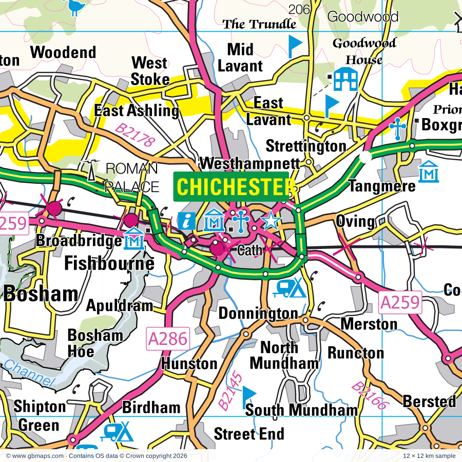
Explore the full 60 × 60 km Chichester regional road map at 1:250,000, covering Petersfield, Midhurst, Horndean, Emsworth, Bordon. Compare the complete coverage below; a detailed PDF sample is available free.

CHICHESTER & SURROUNDING AREAREGIONAL ROAD MAP
60 × 60 km · Full map previewDownload the free SVG ↓

INSIDE THE FULL 60 × 60 KM MAP

Explore the Chichester map area

1:250,000 cartography

Towns, villages & places

More mapped places (317)

Roads across this sheet

M3, M27, M275, A3, A3(M), A25, A27, A29, A30, A31, A32, A33, A246, A248, A259, A264, A272, A280, A281, A283, A284, A285, A286, A287

More road numbers

A288, A320, A323, A325, A331, A333, A334, A339, A397, A2013, A2030, A2047, A3016, A3020, A3021, A3023, A3051, A3054, A3055, A3100, B2070, B2126, B2127, B2128, B2130, B2131, B2132, B2133, B2138, B2139, B2140, B2141, B2144, B2145, B2146, B2147, B2148, B2149, B2150, B2151, B2152, B2154, B2155, B2166, B2177, B2178, B2179, B2187, B2198, B2199, B2201, B2233, B2259, B3000, B3001, B3002, B3004, B3005, B3006, B3007, B3008, B3013, B3035, B3037, B3046, B3047, B3051, B3208, B3320, B3321, B3326, B3330, B3331, B3333, B3334, B3340, B3349, B3354, B3367, B3384, B3385, B3400, B3404

Rivers & waterways

Blackwater River, Chichester Ship Canal, River Arun, River Hamble, River Itchen, River Meon, River Rother, River Slea, River Test, River Wey, River Whitewater, Wey & Arun Canal

Landmarks & landscape

Alice Holt Woodland Park Forest Centre, Go Ape Alice Holt, Allen Gallery & Curtis Museum, Amberley Museum, Amberley Village Pottery, Amberley Wild Brooks Nature Reserve, Arundel Castle, Arundel Castle Gardens, Arundel RC Cathedral, Arundel Toy and Military Museum, Arundel Wildfowl and Wetlands Trust Nature Reserve, Avington Park, Ballards Brewery, SOUTH DOWNS NATIONAL PARK

More named features

Bignor Roman Villa, Birdworld, Bishop's Waltham Museum, Bishop's Waltham Palace, Blue Reef Aquarium, Bognor Regis Local History Museum, Botley Mill, Boxgrove Priory, Brickfields Country Park, Butlins Holiday Centre, Rainbows End, Butser Ancient Farm, Castle, Chase Mill, Chichester Cathedral, Chilworth Manor, Chreode Pottery, Clanfield Pottery, Classic Boat Museum & Gallery, Coultershaw Beam Pump, Cowdray, Cowdray Heritage Trust, Cranleigh Arts Centre, Dapdune Wharf, Denmans Gardens, Diving Museum, Earnley Gardens, East Cowes Heritage Centre, Eastney Beam Engine House, Eastney Pumping Station Industrial Museum, D Day Museum, Emsworth Museum, Farlington Marshes Nature Reserve, Farnham Castle, Farnham Museum, Fishbourne Roman Palace, Fishers Farm Park, Flamingo Park, Appley Tower, Fontwell Park Racecourse, Fort Brockhurst, Fort Nelson (Royal Armouries Museum of Artillery), Godalming Museum, Goodwood Country Park, Goodwood House, Goodwood Racecourse, Gosport Gallery, Guildford, Guildford Cathedral, Guildford Museum, The Undercroft, Guildhall/Priory Museum, The Novium, Harting Downs Nature Reserve, Haslemere Educational Museum, Havant Arts Centre, Hayling Seaside Railway, Highdown Gardens, Hinton Ampner, Hinton Ampner Garden, Hinton Ampner House, Hogs Back Brewery, Hollycombe Steam Collection, Horse Sand Fort, Intech Science Centre, Iping & Stedham Commons Nature Reserve, Isle of Wight Bus & Coach Museum, Isle of Wight Butterfly World, Itchen Abbas Roman Villa, Itchen Valley Brewery, James Hockey Gallery and Foyer Gallery, Jane Austen's House Museum, Kingley Vale National Nature Reserve, Littlehampton Miniature Railway, Littlehampton Museum, Lockwood Donkey Sanctuary, Look and Sea Visitor Centre, Loseley House, Loseley House and Garden, Lurgashall Winery, Manor Farm Country Park, Manor Farm and Country Park, Marwell Wildlife, Mary Rose, Charles Dickens Birthplace Museum, Royal Naval Museum, Meon Pottery, Meon Valley Vineyard, Mid Hants Railway, Nelson's Monument, Newlands Solar Farm, No Man's Land Fort, Noar Hill Nature Reserve, Northbrook Springs Vineyard, Nutbourne Vineyards, Old Winchester Hill Nature Reserve, Osborne House, Pagham Harbour Local Nature Reserve, Pagham Harbour Nature Reserve Visitor Centre, Palace, Pallant House Art Gallery, Parham House, Parham House & Gardens, Petersfield Museum, Petworth Cottage Museum, Petworth Deer Park, Petworth House, Portchester Castle, Portsmouth Anglican Cathedral, Portsmouth City Museum and Art Gallery, Portsmouth Historic Dockyard, Spinnaker Tower, King James's Gate, Portsmouth RC Cathedral, Portsmouth Spinnaker Tower, Pulborough Brooks Nature Reserve, Quarr Abbey, Queen Elizabeth Country Park, Queen Elizabeth Country Park Visitor Centre, RN Submarine Museum, Gosport Museum, 17th Century Experience, Explosion Museum of Naval Firepower, ROMAN VILLA (remains of), Roman Palace, Roman Villa (site of), Royal Garrison Church, Portsmouth Landport Gate, Portsmouth King James Gate, Fort Cumberland, Royal Marines Museum, Cumberland House Natural History Museum, Rural Life Centre Museum, Second World War Aircraft Preservation Society, Selborne Hill Nature Reserve, Selsey Lifeboat Museum, Sharon Orchard, Rosemary Vineyard, Shere Museum, Shortheath Common Nature Reserve, Smallbrook Stadium, Solar Farm, Southsea Castle, Southsea Model Village, Spitsand Fort, Square Tower, Stansted Park, Staunton Country Park, Steventon Pottery, Storrington & District Museum, Swanwick Nature Reserve, Tangmere Military Aviation Museum, Tank Driving Experience, The Grange, The Oates Museum/Gilberts Whites House, The Witley Centre, Titchfield Abbey, Uppark, Wakeners or Waggoners Wells Beauty Spot, Waltzing Waters Aqua Theatre, Waverly Abbey (remains of), Weald and Downland Open Air Museum, West Dean Gardens, Westbury Manor Museum, Whitehill Lane Solar Farm, Wickham Vineyard, Winkworth Arboretum, Witley & Milford Commons Nature Reserve
Local authority & parish coverage

Wholly or partly within the full map rectangle. These boundaries are coverage information, not additional artwork layers.

  • Arun DistrictPartly within
  • Basingstoke and Deane DistrictPartly within
  • Chichester DistrictWholly within
  • City of PortsmouthWholly within
  • East Hampshire DistrictWholly within
  • Eastleigh DistrictPartly within
  • Fareham DistrictPartly within
  • Gosport DistrictWholly within
  • Guildford DistrictPartly within
  • Hart DistrictPartly within
  • Havant DistrictWholly within
  • Horsham DistrictPartly within
  • Isle of WightPartly within
  • Mole Valley DistrictPartly within
  • Rushmoor DistrictPartly within
  • Waverley DistrictPartly within
  • Winchester DistrictPartly within
  • Worthing DistrictPartly within
Wards & electoral divisions 224 areas
  • Aldershot Park Ward (part)
  • Aldwick East Ward
  • Aldwick West Ward
  • Alfold, Dunsfold & Hascombe Ward
  • Alresford & Itchen Valley Ward (part)
  • Alton Amery Ward
  • Alton Ashdell Ward
  • Alton Eastbrooke Ward
  • Alton Holybourne Ward
  • Alton Westbrooke Ward
  • Alton Whitedown Ward
  • Alton Wooteys Ward
  • Alverstoke Ward
  • Anglesey Ward
  • Angmering & Findon Ward (part)
  • Arundel & Walberton Ward
  • Ash South Ward (part)
  • Ash Wharf Ward (part)
  • Avenue Ward
  • Baffins Ward
  • Barnham Ward
  • Basing & Upton Grey Ward (part)
  • Beach Ward
  • Bedhampton Ward
  • Bentworth & Froyle Ward
  • Bersted Ward
  • Billingshurst Ward (part)
  • Binsted, Bentley & Selborne Ward
  • Bishop's Waltham Ward (part)
  • Botley Ward (part)
  • Bramley & Wonersh Ward
  • Bramshott & Liphook Ward
  • Bridgemary Ward
  • Brighton Hill Ward (part)
  • Brockhurst & Privett Ward
  • Brookfield Ward
  • Buriton & East Meon Ward
  • Castle Ward (part)
  • Castle Ward (part)
  • Central Meon Valley Ward
  • Central Southsea Ward
  • Charles Dickens Ward
  • Chichester Central Ward
  • Chichester East Ward
  • Chichester North Ward
  • Chichester South Ward
  • Chichester West Ward
  • Chiddingfold Ward
  • Clandon & Horsley Ward (part)
  • Clanfield Ward
  • Colden Common & Twyford Ward (part)
  • Copnor Ward
  • Cosham Ward
  • Courtwick with Toddington Ward
  • Cowplain Ward
  • Cranleigh East Ward
  • Cranleigh West Ward
  • Crookham West and Ewshot Ward (part)
  • Denmead Ward
  • Drayton and Farlington Ward
  • Easebourne Ward
  • East Preston Ward
  • Eastney and Craneswater Ward
  • Elson Ward
  • Elstead & Peper Harow Ward
  • Emsworth Ward
  • Ewhurst & Ellens Green Ward (part)
  • Fair Oak & Horton Heath Ward (part)
  • Fareham Park Ward
  • Fareham Town Ward
  • Farnham Bourne Ward
  • Farnham Castle Ward
  • Farnham Firgrove Ward
  • Farnham Heath End Ward (part)
  • Farnham Moor Park Ward
  • Farnham North West Ward
  • Farnham Rowledge Ward
  • Farnham Weybourne Ward
  • Felpham East Ward
  • Felpham West Ward
  • Fernhurst Ward
  • Ferring Ward (part)
  • Fittleworth Ward
  • Fort Fareham Ward
  • Forton Ward
  • Four Marks & Medstead Ward
  • Fratton Ward
  • Froxfield, Sheet & Steep Ward
  • Godalming Binscombe & Charterhouse Ward
  • Godalming Central & Ockford Ward
  • Godalming Farncombe & Catteshall Ward
  • Godalming Holloway Ward
  • Goodwood Ward
  • Goring Ward (part)
  • Grange & Alver Valley Ward
  • Grayshott Ward
  • Harbour Villages Ward
  • Harbourside & Town Ward
  • Hardway Ward
  • Hart Plain Ward
  • Harting Ward
  • Haslemere East Ward
  • Haslemere West Ward
  • Hatch Warren & Beggarwood Ward
  • Havant St. Faith's Ward
  • Hayling East Ward
  • Hayling West Ward
  • Headley Ward
  • Hedge End North Ward (part)
  • Hill Head Ward
  • Hilsea Ward
  • Hindhead & Beacon Hill Ward
  • Hook-with-Warsash Ward (part)
  • Horndean Catherington Ward
  • Horndean Downs Ward
  • Horndean Kings & Blendworth Ward
  • Horndean Murray Ward
  • Hotham Ward
  • Itchingfield, Slinfold & Warnham Ward (part)
  • Kempshott & Buckskin Ward (part)
  • Lavant Ward
  • Lee East Ward
  • Lee West Ward
  • Leesland & Newtown Ward
  • Leigh Park Central & West Leigh Ward
  • Leigh Park Hermitage Ward
  • Lindford Ward
  • Liss Ward
  • Locks Heath Ward (part)
  • Loxwood Ward
  • Manor Park Ward (part)
  • Marine Ward
  • Merrow Ward (part)
  • Mickleham, Westcott & Okewood Ward (part)
  • Middleton-on-Sea Ward
  • Midhurst Ward
  • Milford & Witley Ward
  • Milton Ward
  • Nelson Ward
  • Normandy & Pirbright Ward (part)
  • North Mundham & Tangmere Ward
  • North Town Ward (part)
  • Northbrook Ward (part)
  • Oakley & The Candovers Ward (part)
  • Odiham Ward (part)
  • Onslow Ward (part)
  • Orchard Ward
  • Pagham Ward
  • Park Gate Ward
  • Paulsgrove Ward
  • Peel Common Ward
  • Petersfield Bell Hill Ward
  • Petersfield Causeway Ward
  • Petersfield Heath Ward
  • Petersfield St. Peter's Ward
  • Petworth Ward
  • Pevensey Ward
  • Pilgrims Ward (part)
  • Portchester Castle Ward
  • Portchester Wicor Ward
  • Pulborough, Coldwaltham & Amberley Ward
  • Purbrook Ward
  • River Ward
  • Ropley, Hawkley & Hangers Ward
  • Rowhill Ward (part)
  • Rowlands Castle Ward
  • Rowner & Holbrook Ward
  • Rudgwick Ward (part)
  • Rustington East Ward
  • Rustington West Ward
  • Sarisbury & Whiteley Ward (part)
  • Selsey South Ward
  • Shalford Ward
  • Sidlesham with Selsey North Ward
  • Southbourne Ward
  • Southwick & Wickham Ward
  • St. Bartholomew Ward (part)
  • St. Jude Ward
  • St. Nicolas Ward
  • St. Thomas Ward
  • Stakes Ward
  • Stoke Ward (part)
  • Storrington & Washington Ward (part)
  • Stubbington Ward
  • The Witterings Ward
  • The Worthys Ward (part)
  • Tillingbourne Ward (part)
  • Titchfield Common Ward
  • Titchfield Ward
  • Uplands & Funtley Ward
  • Upper Meon Valley Ward (part)
  • Wallington & Downend Ward
  • Waterloo Ward
  • Wellington Ward (part)
  • West Chiltington, Thakeham & Ashington Ward (part)
  • Westborough Ward (part)
  • Westbourne Ward
  • Western Commons Ward
  • Whitchurch, Overton & Laverstoke Ward (part)
  • Whitehill Chase Ward
  • Whitehill Hogmoor & Greatham Ward
  • Whitehill Pinewood Ward
  • Whiteley & Shedfield Ward
  • Wonston & Micheldever Ward (part)
  • Worplesdon Ward (part)
  • Yapton Ward
  • Binstead & Fishbourne ED
  • Brading & St. Helens ED (part)
  • Cowes Medina ED (part)
  • Cowes South & Northwood ED (part)
  • East Cowes ED (part)
  • Fairlee & Whippingham ED (part)
  • Haylands & Swanmore ED (part)
  • Nettlestone & Seaview ED (part)
  • Newchurch, Havenstreet & Ashey ED (part)
  • Newport Central ED (part)
  • Osborne ED
  • Parkhurst & Hunnyhill ED (part)
  • Ryde Appley & Elmfield ED
  • Ryde Monktonmead ED
  • Ryde North West ED
  • Ryde South East ED
  • Ryde West ED
  • Wootton Bridge ED (part)
Civil parishes & communities 266 areas
  • Abinger CP (part)
  • Albury CP (part)
  • Aldingbourne CP
  • Aldwick CP
  • Alfold CP
  • Alton CP
  • Amberley CP
  • Angmering CP
  • Appledram CP
  • Artington CP
  • Arundel CP
  • Ash CP (part)
  • Barlavington CP
  • Barnham and Eastergate CP
  • Beauworth CP
  • Beech CP
  • Bentley CP
  • Bentworth CP
  • Bepton CP
  • Bersted CP
  • Bighton CP
  • Bignor CP
  • Billingshurst CP (part)
  • Binsted CP
  • Birdham CP
  • Bishops Sutton CP
  • Bishops Waltham CP
  • Boarhunt CP
  • Bognor Regis CP
  • Bosham CP
  • Botley CP (part)
  • Boxgrove CP
  • Brading CP (part)
  • Bradley CP
  • Bramdean and Hinton Ampner CP
  • Bramley CP
  • Bramshott and Liphook CP
  • Buriton CP
  • Burpham CP
  • Bury CP
  • Candovers CP
  • Chawton CP
  • Cheriton CP
  • Chichester CP
  • Chiddingfold CP
  • Chidham and Hambrook CP
  • Chilcomb CP (part)
  • Churt CP
  • Clanfield CP
  • Clapham CP (part)
  • Cliddesden CP (part)
  • Climping CP
  • Cocking CP
  • Colden Common CP (part)
  • Coldwaltham CP
  • Colemore and Priors Dean CP
  • Compton CP
  • Compton CP
  • Corhampton and Meonstoke CP
  • Cowes CP (part)
  • Cranleigh CP
  • Crondall CP (part)
  • Curdridge CP
  • Deane CP (part)
  • Denmead CP
  • Dockenfield CP
  • Donnington CP
  • Droxford CP
  • Dummer CP
  • Duncton CP
  • Dunsfold CP
  • Durley CP (part)
  • Earnley CP
  • Eartham CP
  • Easebourne CP
  • East Cowes CP (part)
  • East Dean CP
  • East Lavington CP
  • East Meon CP
  • East Preston CP
  • East Tisted CP
  • East Wittering CP
  • Ebernoe CP
  • Ellisfield CP
  • Elstead CP
  • Elsted and Treyford CP
  • Ewhurst CP (part)
  • Ewshot CP (part)
  • Exton CP
  • Fair Oak and Horton Heath CP (part)
  • Farleigh Wallop CP
  • Farnham CP (part)
  • Farringdon CP
  • Felpham CP
  • Fernhurst CP
  • Ferring CP (part)
  • Findon CP (part)
  • Fishbourne CP
  • Fishbourne CP
  • Fittleworth CP
  • Ford CP
  • Four Marks CP
  • Frensham CP
  • Froxfield and Privett CP
  • Froyle CP
  • Funtington CP
  • Godalming CP
  • Graffham CP
  • Grayshott CP
  • Greatham CP
  • Greywell CP (part)
  • Hambledon CP
  • Hambledon CP
  • Harting CP
  • Hascombe CP
  • Haslemere CP
  • Havenstreet and Ashey CP (part)
  • Hawkley CP
  • Headley CP
  • Hedge End CP (part)
  • Herriard CP
  • Heyshott CP
  • Horndean CP
  • Houghton CP
  • Hunston CP
  • Itchen Stoke and Ovington CP
  • Itchen Valley CP (part)
  • Kilmiston CP
  • Kings Worthy CP (part)
  • Kingsley CP
  • Kingston CP
  • Kirdford CP
  • Langrish CP
  • Lasham CP
  • Lavant CP
  • Laverstoke CP (part)
  • Linch CP
  • Linchmere CP
  • Lindford CP
  • Liss CP
  • Littlehampton CP
  • Lodsworth CP
  • Long Sutton CP
  • Loxwood CP
  • Lurgashall CP
  • Lyminster and Crossbush CP
  • Madehurst CP
  • Mapledurwell and Up Nately CP (part)
  • Marden CP
  • Medstead CP
  • Micheldever CP (part)
  • Middleton-on-Sea CP
  • Midhurst CP
  • Milland CP
  • Munstead and Tuesley CP
  • Nettlestone and Seaview CP (part)
  • New Alresford CP
  • Newlands CP
  • Newport and Carisbrooke CP (part)
  • Newton Valence CP
  • Normandy CP (part)
  • North Mundham CP
  • North Waltham CP
  • Northchapel CP
  • Northington CP
  • Northwood CP (part)
  • Nutley CP
  • Oakley CP (part)
  • Odiham CP (part)
  • Old Alresford CP
  • Overton CP (part)
  • Oving CP
  • Owslebury CP (part)
  • Pagham CP
  • Parham CP
  • Patching CP
  • Peper Harow CP
  • Petersfield CP
  • Petworth CP
  • Plaistow CP
  • Poling CP
  • Popham CP
  • Preston Candover CP
  • Pulborough CP
  • Puttenham CP
  • Rogate CP
  • Ropley CP
  • Rowlands Castle CP
  • Rudgwick CP (part)
  • Rustington CP
  • Ryde CP (part)
  • Seale and Sands CP
  • Selborne CP
  • Selsey CP
  • Shackleford CP
  • Shalden CP
  • Shalford CP
  • Shedfield CP
  • Sheet CP
  • Shere CP (part)
  • Sidlesham CP
  • Singleton CP
  • Slindon CP
  • Slinfold CP (part)
  • Soberton CP
  • South Stoke CP
  • South Warnborough CP (part)
  • Southbourne CP
  • Southwick and Widley CP
  • St. Helens CP (part)
  • St. Martha CP
  • Stedham with Iping CP
  • Steep CP
  • Steventon CP
  • Stopham CP
  • Storrington and Sullington CP (part)
  • Stoughton CP
  • Stroud CP
  • Sutton CP
  • Swanmore CP
  • Tangmere CP
  • Thakeham CP (part)
  • Thursley CP
  • Tichborne CP
  • Tilford CP
  • Tillington CP
  • Tongham CP
  • Trotton with Chithurst CP
  • Tunworth CP (part)
  • Twyford CP (part)
  • Upham CP
  • Upton Grey CP (part)
  • Upwaltham CP
  • Walberton CP
  • Wanborough CP (part)
  • Warnford CP
  • Warningcamp CP
  • West Chiltington CP (part)
  • West Clandon CP (part)
  • West Dean CP
  • West Horsley CP (part)
  • West Itchenor CP
  • West Lavington CP
  • West Meon CP
  • West Thorney CP
  • West Tisted CP
  • West Wittering CP
  • Westbourne CP
  • Westhampnett CP
  • Weston Corbett CP
  • Weston Patrick CP
  • Whippingham CP
  • Whitehill CP
  • Whiteley CP
  • Wickham and Knowle CP
  • Wield CP
  • Winslade CP (part)
  • Wisborough Green CP
  • Witley and Milford CP
  • Wonersh CP
  • Wonston CP (part)
  • Woolbeding with Redford CP
  • Wootton Bridge CP (part)
  • Worldham CP
  • Worplesdon CP (part)
  • Yapton CP

Source: the GBMaps road atlas, OS Boundary-Line and postcode mapping datasets. Source editions are being checked for publication. Unmarked boundary names are wholly within the sheet; “part” means the map edge crosses the area.

Place lists are selected from the map source, not a complete gazetteer. Named features describe the cartography; visitor facilities and opening status are not verified. The free sample covers only 12 × 12 km of this larger sheet.

INSIDE YOUR DOWNLOAD

A proper road map, in useful formats

Road classifications, towns and villages, railways, rivers, landscape detail and tourist symbols, brought together in the GBMaps regional road atlas style.

PDF filePDFSVG fileSVGAdobe Illustrator AI fileAi

PDF for the finished map. SVG and layered Illustrator artwork for adapting colours, adding your own information and preparing designs.

THE FINISHED SHEET

Designed for print and presentation

Map coverage
60 × 60 km
Sample coverage
12 × 12 km
Print layout
A3 landscape · enlarged 1:250k cartography
Sheet furniture
Border, scale bar, key & north arrow

A few useful details

What changes when I select another square?

Select a surrounding square to bring it into the centre and reveal the maps around it. Each square is a different 60 × 60 km map. The preview, free sample and selected download change together. Neighbouring sheets overlap by 30 km so you can choose the coverage that suits you.

Is the free sample a vector map?

The on-page detail is an SVG. The free download is a separate 12 × 12 km PDF with a link to the full map. Please retain its copyright credits and product link when sharing it.

Can I buy a larger combined map?

These downloads are individual ready-made sheets. Contact GBMaps if you need a larger combined area.

FREE PDF SAMPLE

Your free map sample

Your free 12 × 12 km sample includes a link back to this map, so you can return for the full area whenever you need it.

Download free PDF sample ↓

Get your Chichester map

Map download bundle

£24.00including VATOne payment

Pay securely

One payment. Your map stays open.

Your map download

Your map files

Preparing your download…

Checking your private download link…

Your map downloads

Already bought a map?

Find the downloads from your purchases.

Enter the email address you used at checkout. We’ll email you a private link to your available map downloads.