Carsaig regional road map. Full 60 × 60 km PDF, SVG and Illustrator files, with a free PDF sample.

GBMAPS.COM

Carsaig Regional Road Map

Call Us Now for Help01751 473136

GREAT BRITAIN ROAD ATLAS · 1:250,000 GB-150-0720

Carsaig & surrounding area

Explore the full 60 × 60 km Carsaig regional road map at 1:250,000, covering Carsaig, Pennyghael, Lee, Ardchiavaig, Bunessan. Compare the complete coverage below; a detailed PDF sample is available free.

CARSAIG & SURROUNDING AREAREGIONAL ROAD MAP
60 × 60 km · Full map previewDownload the free SVG ↓

INSIDE THE FULL 60 × 60 KM MAP

Explore the Carsaig map area

1:250,000 cartography

Towns, villages & places

  • Carsaig
  • Pennyghael
  • Lee
  • Ardchiavaig
  • Bunessan
  • Lochbuie
  • Eorabus
  • Aridhglas
  • Kintra
  • Fionnphort
  • Gruline
  • Kellan
  • Strathcoil
  • Killiechronan
  • Croggan
  • Salen
  • Ballygown
  • Uragaig
More mapped places (18)
  • Cullipool
  • Ellenabeich
  • Aros
  • Fanmore
  • Cuan
  • Lochdon
  • Balvicar
  • Toberonochy
  • Kilninian
  • Craignure
  • Scalasaig
  • Burg
  • Fiunary
  • Lochaline
  • Lunga
  • Aird
  • Claggan
  • Crinan

Roads across this sheet

A816, A848, A849, A884, B841, B844, B849, B8002, B8003, B8025, B8035, B8073, B8085, B8086, B8087

Rivers & waterways

Allt Beitheach, Aros River, Beach River, Coladoir River, Crinan Canal, Lealt Burn, Leidle River, Lussa River, Rannoch River, River Aline, River Forsa

Landmarks & landscape

An Cala, Ardencaple House, Ardmaddy Castle, Ardnoe Cycle Route, Ardtornish, Arduaine Garden, Atlantic Islands Visitor Centre, Ballachuan Hazelwood Nature Reserve, Barnhill, Broch, Carsaig Arches, Castle

More named features

Chapel, Clachan Bridge, Colonsay Heritage Centre, Colonsay House Garden, Corryvreckan Whirlpool, Craobh Haven Marina, Creach Ben Lodge, Cycle Trail, Duart Castle, Duntrune Castle, Eas Fors (Waterfall), Easdale Island Folk Museum, Eileach-an Naoimh Monastery (remains of), Ellenabeich Heritage Centre, Ellenabeich Heritage Centre, Highland Arts Exhibition, Fingal's Cave, Glenaros House, Gruline House, Inch Kenneth Chapel, Iona Abbey, Iona Pottery, Isle of Ulva Heritage Centre, Kengharair Farm, Kilmory Lodge, Kinuachdrachd Camping Barn, Kirkton Chapel, Laggan Lodge, Loch Tearnait Hydro Scheme Power House, MacCulloch's Fossil Tree, Maclean's Cross, Iona Heritage Centre, Macleans Cross, Morvern Gallery, Museum, Sculptured Stones, Stone Circle, Tavool House, The Columba Visitor Centre, The Macquarie Mausoleum, Tigh na Rois Historical Visitor Centre, Torosay Castle, Ulva House

Local authority & parish coverage

Wholly or partly within the full map rectangle. These boundaries are coverage information, not additional artwork layers.

  • Argyll and ButePartly within
  • HighlandPartly within
Wards & electoral divisions 5 areas
  • Fort William and Ardnamurchan Ward (part)
  • Kintyre and the Islands Ward (part)
  • Mid Argyll Ward (part)
  • Oban North and Lorn Ward (part)
  • Oban South and the Isles Ward (part)
Civil parishes & communities 0 areas

    Source: the GBMaps road atlas, OS Boundary-Line and postcode mapping datasets. Source editions are being checked for publication. Unmarked boundary names are wholly within the sheet; “part” means the map edge crosses the area.

    Place lists are selected from the map source, not a complete gazetteer. Named features describe the cartography; visitor facilities and opening status are not verified. The free sample covers only 12 × 12 km of this larger sheet.

    INSIDE YOUR DOWNLOAD

    A proper road map, in useful formats

    Road classifications, towns and villages, railways, rivers, landscape detail and tourist symbols, brought together in the GBMaps regional road atlas style.

    PDF filePDFSVG fileSVGAdobe Illustrator AI fileAi

    PDF for the finished map. SVG and layered Illustrator artwork for adapting colours, adding your own information and preparing designs.

    THE FINISHED SHEET

    Designed for print and presentation

    Map coverage
    60 × 60 km
    Sample coverage
    12 × 12 km
    Print layout
    A3 landscape · enlarged 1:250k cartography
    Sheet furniture
    Border, scale bar, key & north arrow

    A few useful details

    What changes when I select another square?

    Select a surrounding square to bring it into the centre and reveal the maps around it. Each square is a different 60 × 60 km map. The preview, free sample and selected download change together. Neighbouring sheets overlap by 30 km so you can choose the coverage that suits you.

    Is the free sample a vector map?

    The on-page detail is an SVG. The free download is a separate 12 × 12 km PDF with a link to the full map. Please retain its copyright credits and product link when sharing it.

    Can I buy a larger combined map?

    These downloads are individual ready-made sheets. Contact GBMaps if you need a larger combined area.
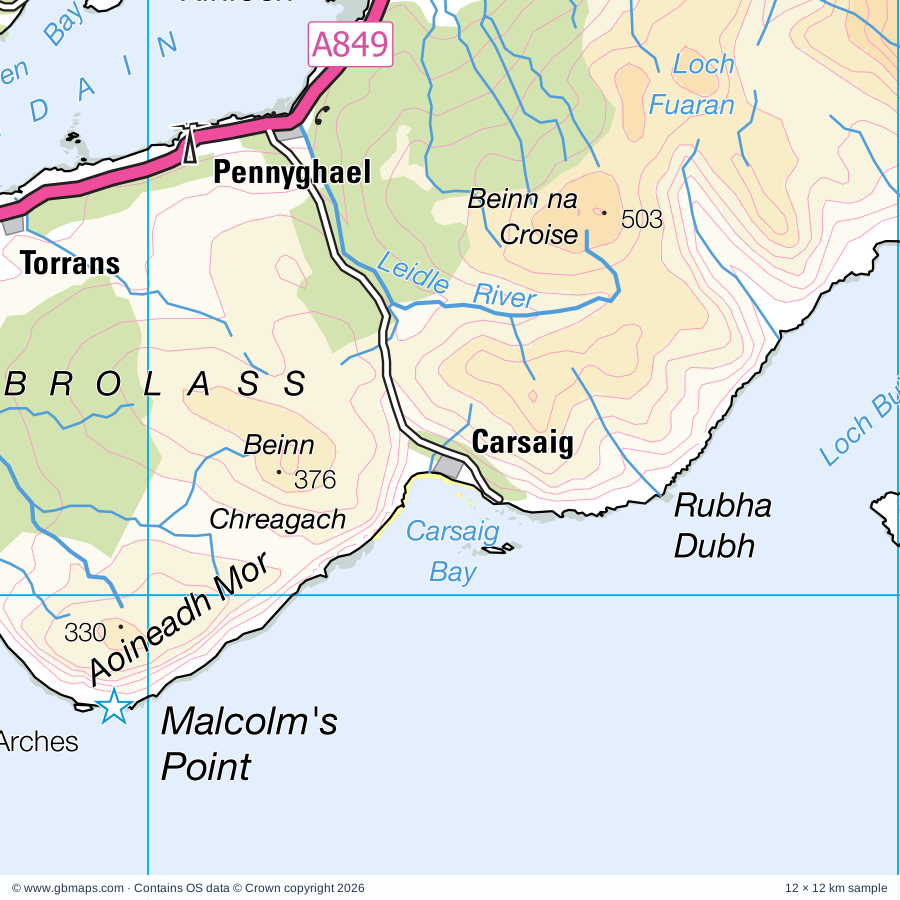
    FREE PDF SAMPLE

    Your free map sample

    Your free 12 × 12 km sample includes a link back to this map, so you can return for the full area whenever you need it.

    Download free PDF sample ↓

    Get your Carsaig map

    Map download bundle

    £24.00including VATOne payment

    Pay securely

    One payment. Your map stays open.

    Your map download

    Your map files

    Preparing your download…

    Checking your private download link…

    Your map downloads

    Already bought a map?

    Find the downloads from your purchases.

    Enter the email address you used at checkout. We’ll email you a private link to your available map downloads.