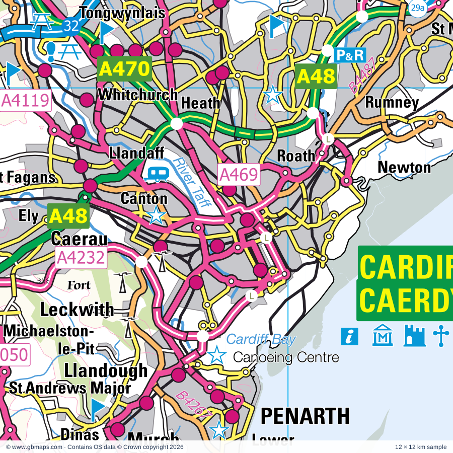
Cardiff regional road map. Full 60 × 60 km PDF, SVG and Illustrator files, with a free PDF sample.

GBMAPS.COM

Cardiff Regional Road Map

Call Us Now for Help01751 473136

GREAT BRITAIN ROAD ATLAS · 1:250,000 GB-300-0180

Cardiff & surrounding area

Explore the full 60 × 60 km Cardiff regional road map at 1:250,000, covering Pencoed, Cowbridge, Llantrisant, Bridgend, Porth. Compare the complete coverage below; a detailed PDF sample is available free.

CARDIFF & SURROUNDING AREAREGIONAL ROAD MAP
60 × 60 km · Full map previewDownload the free SVG ↓

INSIDE THE FULL 60 × 60 KM MAP

Explore the Cardiff map area

1:250,000 cartography

Towns, villages & places

More mapped places (190)

Roads across this sheet

M4, A48, A48(M), A467, A468, A469, A470, A472, A473, A474, A483, A4043, A4046, A4047, A4048, A4049, A4050, A4051, A4054, A4055, A4058, A4059, A4061, A4063

More road numbers

A4064, A4065, A4067, A4068, A4072, A4093, A4102, A4106, A4107, A4109, A4119, A4160, A4161, A4222, A4225, A4226, A4229, A4230, A4231, A4232, A4233, A4234, A4241, A4281, B4181, B4223, B4237, B4239, B4242, B4246, B4248, B4251, B4252, B4254, B4255, B4256, B4257, B4261, B4262, B4263, B4264, B4265, B4266, B4267, B4268, B4270, B4273, B4275, B4276, B4278, B4280, B4281, B4282, B4283, B4285, B4286, B4287, B4290, B4291, B4294, B4434, B4471, B4478, B4486, B4487, B4488, B4511, B4512, B4522, B4524, B4562, B4564, B4591, B4595, B4599, B4600, B4603, B4622, B4623, B4625

Rivers & waterways

Afon Afan / River Avan, Afon Cynon, Afon Ddawan / River Thaw, Afon Ewenny / Ewenny River, Afon Hepste, Afon Mellte, Afon Pelenna / Pelena River, Afon Rhondda Fach, Afon Twrch, Dulais, Ebbw River / Afon Ebwy, Ely River

More waterways

Monmouthshire & Brecon Canal, Nant y Dderwen-deg / Roath Brook, Neath Canal, Nedd Fechan, Ogmore River / Afon Ogwr, Ogwr Fach, Ogwr Fawr, Rhondda River / Afon Rhondda Fawr, Rhymney River / Afon Rhymni, River Neath / Afon Nedd, River Taff, River Tawe, Sirhowy River, Swansea Canal (disused), Tennant Canal

Landmarks & landscape

Aberdulais Falls, Afan Argoed Country Park, Amelia Trust Farm, Barry Island Pleasure Park, Barry Rail Centre, Barry Sidings Countryside Park-Heritage Park, Beaupre Castle, Bedford Park Country Park, Big Pit National Museum of Mining (World Heritage Site), Blaenavon Iron Works (World Heritage Site), Rhymney Brewery, Bleanavon Heritage & Cordell Museum, Blaenavon World Heritage Centre, Brean Down Fort, BRECON BEACONS NATIONAL PARK, EXMOOR NATIONAL PARK

More named features

Brecon Mountain Railway, Bryngarw Country Park, Caerphilly Castle, Caisson, Cardiff Castle, Castell Coch, Cefn Coed Colliery Museum, Cefn Mably Farm Park, Chapter Arts Centre, Llanover Hall Arts Centre, Coity Castle, Coney Beach Amusement Park, Cosmeston Lakes Country Park, Cosmeston Medieval Village, Cyfartha Museum & Art Gallery, Ynysfach Iron Heritage Centre, Joseph Parry's Cottage, Cynon Valley Museum, Dare Valley Country Park, Diamond Park, Doctor Who Experience, Dyffryn Gardens, Elliot's Colliery Winding House Museum, Ewenny Priory, Fforest Uchaf Horse or Pony Centre, Five Locks Canal Nature Reserve, Flat Holm Nature Reserve, Fonmon Castle, Fourteen Locks Canal Centre, Glamorgan Heritage Coast Centre, Glyncorrwg Mountain Bike Centre, Greenmeadow Community Farm, International Sports Venue, Canoeing & Rafting, Kenfig Nature Reserve Visitor Centre, Kenfig Pool Nature Reserve, Lancaiach Fawr, Llanblethian Castle, Llandaff Cathedral, Cardiff Cathedral, Llanerch Vineyard, Long Cairn, Lyn & Exmoor Museum, Water Power Museum, Makers Guild in Wales-Craft in the Bay, Margam Abbey (remains of), Margam Country Park, Melincourt Waterfall, Model House Craft and Design Centre, Museum, Nantgarw China Works, National Indoor Athletics Centre, National Museum & Gallery, Welch Regiment Museum, Butetown History and Arts Centre, Neath Abbey, Newcastle Castle, Ogmore Castle, Parc Cefn Onn Country Park, Parc Cwm Darran Country Park, Parc Cwm Darren, Parc Penalta Country Park, Parc Slip Nature Park with Visitor Centre, Pen-y-fan Pond Country Park, Penderyn Distillery, Penderyn Distillery Visitor Centre, Pontypool & Blaenavon Railway, Pontypool Museum, Pontypridd Museum, Porthcawl Museum, Porthkerry Country Park, Rare Breeds Centre, Rhondda Heritage Park, Ruperra Castle, Seawatch Centre, Sirhowy Valley Country Park, Six Bells Mining Monument, Solar Farm, South Wales Miners' Museum, St Fagans National History Museum, St Lythans Burial Chamber, Stones Museum, Techniquest, The Assembly at the Pierhead, Norwegian Church Arts Centre,Dr Who Experience, Motorpoint Arena, The Ebbw Vale Works Museum, The Gnoll Estate, Tinkinswood Burial Chamber, Tondu Iron Park, Tredegar House, Tredegar House Country Park, Tredegar House Gardens, Turner House Gallery, Visitor Centre, Warren Mill Farm Park, Welsh Hawking Centre, Woodside Craft Centre, Lyn Valley Arts
Local authority & parish coverage

Wholly or partly within the full map rectangle. These boundaries are coverage information, not additional artwork layers.

  • Abertawe - SwanseaPartly within
  • Blaenau Gwent - Blaenau GwentPartly within
  • Bro Morgannwg - the Vale of GlamorganWholly within
  • Caerdydd - CardiffWholly within
  • Caerffili - CaerphillyPartly within
  • Casnewydd - NewportPartly within
  • Castell-nedd Port Talbot - Neath Port TalbotPartly within
  • City of BristolPartly within
  • Merthyr Tudful - Merthyr TydfilPartly within
  • North Devon DistrictPartly within
  • North SomersetPartly within
  • Pen-y-bont ar Ogwr - BridgendWholly within
  • Powys - PowysPartly within
  • Rhondda Cynon Taf - Rhondda Cynon TafPartly within
  • Sir Fynwy - MonmouthshirePartly within
  • Sir Gaerfyrddin - CarmarthenshirePartly within
  • SomersetPartly within
  • Torfaen - TorfaenPartly within
Wards & electoral divisions 258 areas
  • Avonmouth & Lawrence Weston Ward (part)
  • Lynton & Lynmouth Ward (part)
  • Weston-super-Mare Central Ward (part)
  • Weston-super-Mare Hillside Ward (part)
  • Weston-super-Mare Uphill Ward (part)
  • Aber Valley ED
  • Aber-craf and Ystradgynlais ED (part)
  • Aberaman ED
  • Aberavon ED
  • Aberbargoed and Bargoed ED
  • Abercarn ED
  • Abercynon ED
  • Aberdare East ED
  • Aberdare West and Llwydcoed ED
  • Aberdulais ED
  • Aberkenfig ED
  • Abersychan ED
  • Abertillery and Six Bells ED
  • Adamsdown ED
  • Allt-wen ED
  • Allt-yr-yn ED (part)
  • Argoed ED
  • Baglan ED
  • Baruc ED
  • Beddau and Tyn-y-nant ED
  • Bedlinog and Trelewis ED
  • Bedwas and Trethomas ED
  • Bettws ED (part)
  • Blackmill ED
  • Blackwood ED
  • Blaenavon ED (part)
  • Blaengwrach and Glynneath West ED
  • Blaina ED (part)
  • Bon-y-maen ED (part)
  • Brackla East Central ED
  • Brackla East and Coychurch Lower ED
  • Brackla West Central ED
  • Brackla West ED
  • Brent ED (part)
  • Bridgend Central ED
  • Briton Ferry East ED
  • Briton Ferry West ED
  • Bryn and Cwmavon ED
  • Bryn-coch North ED
  • Bryn-coch South ED
  • Brynna and Llanharan ED
  • Bryntirion, laleston and Merthyr Mawr ED
  • Burnham on Sea North ED (part)
  • Butetown ED
  • Buttrills ED
  • Cadoc ED
  • Cadoxton ED
  • Caerau ED
  • Caerau ED
  • Cannington ED (part)
  • Canton ED
  • Castleland ED
  • Cathays ED
  • Cefn Fforest and Pengam ED
  • Cefn-glas ED
  • Church Village ED
  • Cilfynydd ED
  • Cimla and Pelenna ED
  • Clydach ED (part)
  • Coed Eva ED
  • Coedffranc Central ED
  • Coedffranc North ED
  • Coedffranc West ED (part)
  • Coity Higher ED
  • Cornelly ED
  • Cornerswell ED
  • Court ED
  • Cowbridge ED
  • Croesyceiliog ED (part)
  • Crosskeys ED
  • Crumlin ED
  • Crynant, Onllwyn and Seven Sisters ED (part)
  • Cwm Clydach ED
  • Cwm ED
  • Cwm-twrch ED (part)
  • Cwmbach ED
  • Cwmllynfell and Ystalyfera ED (part)
  • Cwmtillery ED
  • Cyfarthfa ED
  • Cymer ED
  • Cymer and Glyncorrwg ED
  • Cyncoed ED
  • Darran Valley ED
  • Dinas Powys ED
  • Dowlais and Pant ED (part)
  • Dyfan ED
  • Dyffryn ED
  • Ebbw Vale North ED (part)
  • Ebbw Vale South ED
  • Ely ED
  • Fairwater ED
  • Fairwater ED
  • Ferndale and Maerdy ED
  • Gabalfa ED
  • Gaer ED (part)
  • Garnant ED (part)
  • Garw Valley ED
  • Georgetown ED
  • Gibbonsdown ED
  • Gilfach ED
  • Gilfach-goch ED
  • Glyn-coch ED
  • Glynneath Central and East ED
  • Godre'r Graig ED
  • Goetre Fawr ED (part)
  • Graig ED
  • Graig and Pontypridd West ED
  • Grangetown ED
  • Greenmeadow ED
  • Gurnos ED
  • Gwaun-Cae-Gurwen and Lower Brynamman ED (part)
  • Gwynfi and Croeserw ED
  • Hawthorn and Lower Rhydfelen ED
  • Heath ED
  • Hengoed ED
  • Hirwaun, Penderyn and Rhigos ED (part)
  • Illtyd ED
  • Lisvane and Thornhill ED
  • Llanbradach ED
  • Llandaff ED
  • Llandaff North ED
  • Llandough ED
  • Llandow ED
  • Llanfoist Fawr and Govilon ED (part)
  • Llangynwyd ED
  • Llanharry ED
  • Llanhilleth ED
  • Llanishen ED
  • Llanrumney ED
  • Llansamlet ED (part)
  • Llantarnam ED (part)
  • Llantrisant and Talbot Green ED
  • Llantwit Fardre ED
  • Llantwit Major ED
  • Llanyrafon ED (part)
  • Llwyn-y-pia ED
  • Machen and Rudry ED
  • Maesteg East ED
  • Maesteg West ED
  • Maesycwmmer ED
  • Malpas ED (part)
  • Margam and Tai-bach ED
  • Merthyr Vale ED
  • Morgan Jones ED
  • Moriah and Pontlottyn ED
  • Mountain Ash ED
  • Nant-y-Moel ED
  • Nantyglo ED (part)
  • Neath East ED
  • Neath North ED
  • Neath South ED
  • Nelson ED
  • New Inn ED (part)
  • New Tredegar ED
  • Newbridge ED
  • Newton ED
  • Nottage ED
  • Ogmore Vale ED
  • Oldcastle ED
  • Panteg ED (part)
  • Park ED
  • Pen-y-Fai ED
  • Pen-y-graig ED
  • Pen-y-waun ED
  • Pencoed and Penprysg ED
  • Penmaen ED
  • Penrhiw-ceibr ED
  • Pentre ED
  • Pentwyn ED
  • Pentyrch and St. Fagans ED
  • Penydarren ED
  • Penylan ED
  • Penyrheol ED
  • Peterston-super-Ely ED
  • Plasnewydd ED
  • Plymouth ED
  • Plymouth ED
  • Pontardawe ED (part)
  • Pontllanfraith ED
  • Pontnewydd ED
  • Pontnewynydd and Snatchwood ED
  • Pontprennau and Old St. Mellons ED
  • Pontyclun Central ED
  • Pontyclun East ED
  • Pontyclun West ED
  • Pontypool Fawr ED
  • Pontypridd Town ED
  • Port Talbot ED
  • Porth ED
  • Porthcawl East Central ED
  • Porthcawl West Central ED
  • Pyle, Kenfig Hill and Cefn Cribwr ED
  • Radyr ED
  • Resolven and Tonna ED
  • Rest Bay ED
  • Rhiwbina ED
  • Rhoose ED
  • Rhos ED
  • Rhydfelen Central ED
  • Risca East ED
  • Risca West ED
  • Riverside ED
  • Rogerstone East ED
  • Rogerstone North ED
  • Rogerstone West ED
  • Rumney ED
  • Sandfields East ED
  • Sandfields West ED
  • Shaftesbury ED (part)
  • Sirhowy ED (part)
  • Splott ED
  • St. Athan ED
  • St. Augustine's ED
  • St. Bride's Major ED
  • St. Bride's Minor and Ynysawdre ED
  • St. Cattwg ED
  • St. Dials ED
  • St. Martins ED
  • St. Nicholas and Llancarfan ED
  • Stanwell ED
  • Sully ED
  • Taff's Well ED
  • Tawe Uchaf ED (part)
  • Ton-teg ED
  • Tonypandy ED
  • Tonyrefail East ED
  • Tonyrefail West ED
  • Town ED
  • Trallwng ED
  • Trealaw ED
  • Trebanos ED
  • Tredegar ED (part)
  • Tredegar Park and Marshfield ED (part)
  • Treforest ED
  • Treharris ED
  • Treherbert ED
  • Treorchy ED
  • Trevethin and Penygarn ED
  • Trowbridge ED
  • Two Locks ED
  • Twyn Carno ED (part)
  • Tylorstown and Ynyshir ED
  • Upper Cwmbran ED
  • Upper Rhydfelen and Glyn-taf ED
  • Van ED
  • Vaynor ED (part)
  • Wenvoe ED
  • Whitchurch and Tongwynlais ED
  • Ynyscedwyn ED (part)
  • Ynysddu ED
  • Ynysybwl ED
  • Ystrad ED
  • Ystrad Mynach ED
Civil parishes & communities 245 areas
  • Aber Valley Community
  • Aberaman North Community
  • Aberaman South Community
  • Aberavon Community
  • Abercarn Community
  • Abercynon Community
  • Aberdare East Community
  • Aberdare West Community
  • Abersychan Community
  • Abertillery Community
  • Adamsdown Community
  • Allt-yr-Yn Community (part)
  • Argoed Community
  • Baglan Bay Community
  • Baglan Community
  • Baglan Moors Community
  • Bargoed Community
  • Barry Community
  • Bedlinog Community
  • Bedwas, Trethomas and Machen Community
  • Berrow CP (part)
  • Bettws Community (part)
  • Birchgrove Community (part)
  • Blackwood Community
  • Blaenavon Community (part)
  • Blaengwrach Community
  • Blaenhonddan Community
  • Bonymaen Community (part)
  • Brackla Community
  • Brean CP (part)
  • Brendon and Countisbury CP (part)
  • Bridgend Community
  • Briton Ferry Community
  • Bryn Community
  • Burnham-on-Sea and Highbridge CP (part)
  • Butetown Community
  • Caerau Community
  • Caerphilly Community
  • Canton Community
  • Castle Community
  • Cathays Community
  • Cefn Cribwr Community
  • Cefn Fforest Community
  • Cilybebyll Community
  • Clydach Community (part)
  • Clyne and Melincourt Community
  • Coedffranc Community (part)
  • Coedkernew Community
  • Coity Higher Community
  • Colwinston Community
  • Cornelly Community
  • Cowbridge with Llanblethian Community
  • Coychurch Higher Community
  • Coychurch Lower Community
  • Croesyceiliog Community (part)
  • Crosskeys Community
  • Crumlin Community
  • Crynant Community
  • Cwm Clydach Community
  • Cwm Community
  • Cwmamman Community (part)
  • Cwmavon Community
  • Cwmbach Community
  • Cwmbran Central Community (part)
  • Cwmllynfell Community (part)
  • Cyfarthfa Community
  • Cymer and Glyncorrwg Community
  • Cymmer Community
  • Cyncoed Community
  • Darran Valley Community
  • Dinas Powys Community
  • Dowlais Community
  • Dyffryn Clydach Community
  • Ebbw Vale North Community (part)
  • Ebbw Vale South Community
  • Ely Community
  • Ewenny Community
  • Fairwater Community
  • Fairwater Community
  • Ferndale Community
  • Gabalfa Community
  • Gaer Community (part)
  • Garw Valley Community
  • Gelligaer Community
  • Gilfach Goch Community
  • Glynneath Community
  • Goetre Fawr Community (part)
  • Graig Community
  • Grangetown Community
  • Gurnos Community
  • Gwaun-Cae-Gurwen Community (part)
  • Gwynfi and Croeserw Community
  • Heath Community
  • Henllys Community
  • Hirwaun Community (part)
  • Laleston Community
  • Lisvane Community
  • Llanbradach and Pwllypant Community
  • Llancarfan Community
  • Llandaff Community
  • Llandaff North Community
  • Llandough Community
  • Llandow Community
  • Llanedeyrn Community
  • Llanfair Community
  • Llanfoist Fawr Community (part)
  • Llangan Community
  • Llangynwyd Lower Community
  • Llangynwyd Middle Community
  • Llanharan Community
  • Llanharry Community
  • Llanhilleth Community
  • Llanishen Community
  • Llanmaes Community
  • Llanrumney Community
  • Llansamlet Community (part)
  • Llantarnam Community (part)
  • Llantrisant Community
  • Llantwit Fardre Community
  • Llantwit Major Community
  • Llanyrafon Community (part)
  • Llwydcoed Community
  • Llwyn-y-pia Community
  • Lynton and Lynmouth CP (part)
  • Maerdy Community
  • Maesteg Community
  • Maesycwmmer Community
  • Malpas Community (part)
  • Margam Community
  • Margam Moors Community
  • Marshfield Community
  • Mawr Community (part)
  • Merthyr Mawr Community
  • Merthyr Vale Community
  • Michaelston-le-Pit and Leckwith Community
  • Michaelstone-y-Fedw Community
  • Mountain Ash East Community
  • Mountain Ash West Community
  • Nantyglo and Blaina Community (part)
  • Neath Community
  • Nelson Community
  • New Inn Community (part)
  • New Tredegar Community
  • Newbridge Community
  • Newcastle Higher Community
  • Ogmore Valley Community
  • Old St. Mellons Community
  • Onllwyn Community (part)
  • Otterhampton CP (part)
  • Pant Community (part)
  • Panteg Community (part)
  • Park Community
  • Pelenna Community
  • Pen Tranch Community
  • Pen-y-graig Community
  • Pen-y-waun Community
  • Penarth Community
  • Pencoed Community
  • Pendoylan Community
  • Pengam Community
  • Penllyn Community
  • Penmaen Community
  • Penrhiw-ceiber Community
  • Pentre Community
  • Pentwyn Community
  • Pentyrch Community
  • Penydarren Community
  • Penylan Community
  • Penyrheol, Trecenydd and Energlyn Community
  • Peterston-super-Ely Community
  • Pont-y-clun Community
  • Pontardawe Community (part)
  • Pontcanna Community
  • Pontllanfraith Community
  • Pontnewydd Community
  • Pontprennau Community
  • Pontymoile Community
  • Pontypridd Town Community
  • Port Talbot Community
  • Porth Community
  • Porthcawl Community
  • Pyle Community
  • Radyr and Morganstown Community
  • Resolven Community
  • Rhigos Community
  • Rhiwbina Community
  • Rhoose Community
  • Rhymney Community (part)
  • Risca East Community
  • Risca West Community
  • Riverside Community
  • Roath Community
  • Rogerstone Community
  • Rudry Community
  • Rumney Community
  • Sandfields East Community
  • Sandfields West Community
  • Seven Sisters Community (part)
  • Shaftesbury Community (part)
  • Splott Community
  • St. Athan Community
  • St. Bride's Major Community
  • St. Bride's Minor Community
  • St. Donats Community
  • St. Fagans Community
  • St. Georges-super-Ely Community
  • St. Nicholas and Bonvilston Community
  • Sully and Lavernock Community
  • Taffs Well Community
  • Tai-Bach Community
  • Thornhill Community
  • Tongwynlais Community
  • Tonna Community
  • Tonypandy Community
  • Tonyrefail Community
  • Town Community
  • Trealaw Community
  • Tredegar Community (part)
  • Tredegar Park Community (part)
  • Trehafod Community
  • Treharris Community
  • Treherbert Community
  • Tremorfa Community
  • Treorchy Community
  • Trevethin Community
  • Troed-y-rhiw Community
  • Trowbridge Community
  • Tylorstown Community
  • Upper Cwmbran Community
  • Van Community
  • Vaynor Community (part)
  • Welsh St. Donats Community
  • Wentlooge Community (part)
  • Wenvoe Community
  • Weston-Super-Mare CP (part)
  • Whitchurch Community
  • Wick Community
  • Ynysawdre Community
  • Ynysddu Community
  • Ynyshir Community
  • Ynysybwl and Coed-y-Cwm Community
  • Ystalyfera Community (part)
  • Ystrad Community
  • Ystradfellte Community (part)
  • Ystradgynlais Community (part)

Source: the GBMaps road atlas, OS Boundary-Line and postcode mapping datasets. Source editions are being checked for publication. Unmarked boundary names are wholly within the sheet; “part” means the map edge crosses the area.

Place lists are selected from the map source, not a complete gazetteer. Named features describe the cartography; visitor facilities and opening status are not verified. The free sample covers only 12 × 12 km of this larger sheet.

INSIDE YOUR DOWNLOAD

A proper road map, in useful formats

Road classifications, towns and villages, railways, rivers, landscape detail and tourist symbols, brought together in the GBMaps regional road atlas style.

PDF filePDFSVG fileSVGAdobe Illustrator AI fileAi

PDF for the finished map. SVG and layered Illustrator artwork for adapting colours, adding your own information and preparing designs.

THE FINISHED SHEET

Designed for print and presentation

Map coverage
60 × 60 km
Sample coverage
12 × 12 km
Print layout
A3 landscape · enlarged 1:250k cartography
Sheet furniture
Border, scale bar, key & north arrow

A few useful details

What changes when I select another square?

Select a surrounding square to bring it into the centre and reveal the maps around it. Each square is a different 60 × 60 km map. The preview, free sample and selected download change together. Neighbouring sheets overlap by 30 km so you can choose the coverage that suits you.

Is the free sample a vector map?

The on-page detail is an SVG. The free download is a separate 12 × 12 km PDF with a link to the full map. Please retain its copyright credits and product link when sharing it.

Can I buy a larger combined map?

These downloads are individual ready-made sheets. Contact GBMaps if you need a larger combined area.

FREE PDF SAMPLE

Your free map sample

Your free 12 × 12 km sample includes a link back to this map, so you can return for the full area whenever you need it.

Download free PDF sample ↓

Get your Cardiff map

Map download bundle

£24.00including VATOne payment

Pay securely

One payment. Your map stays open.

Your map download

Your map files

Preparing your download…

Checking your private download link…

Your map downloads

Already bought a map?

Find the downloads from your purchases.

Enter the email address you used at checkout. We’ll email you a private link to your available map downloads.