Camelford regional road map. Full 60 × 60 km PDF, SVG and Illustrator files, with a free PDF sample.

GBMAPS.COM

Camelford Regional Road Map

Call Us Now for Help01751 473136

GREAT BRITAIN ROAD ATLAS · 1:250,000 GB-210-0090

Camelford & surrounding area

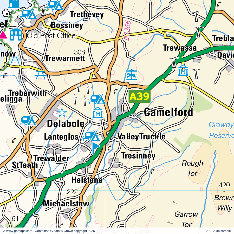
Explore the full 60 × 60 km Camelford regional road map at 1:250,000, covering Camelford, Bude, Wadebridge, Stratton, Bodmin. Compare the complete coverage below; a detailed PDF sample is available free.

CAMELFORD & SURROUNDING AREAREGIONAL ROAD MAP
60 × 60 km · Full map previewDownload the free SVG ↓

INSIDE THE FULL 60 × 60 KM MAP

Explore the Camelford map area

1:250,000 cartography

Towns, villages & places

More mapped places (221)
  • Trewarmett
  • Treknow
  • Marshgate
  • Trewassa
  • Trebarwith
  • Davidstow
  • Otterham
  • Delabole
  • Tremail
  • Valley Truckle
  • Treligga
  • Lanteglos
  • Higher Crackington
  • Middle Crackington
  • Crackington Haven
  • Trewalder
  • Hallworthy
  • Tresinney
  • Trelash
  • St Gennys
  • Helstone
  • St Teath
  • Warbstow
  • Treneglos
  • Jacobstow
  • Michaelstow
  • Trewint
  • St Clether
  • Tregole
  • Churchtown
  • Pendoggett
  • Trelill
  • Canworthy
  • Port Gaverne
  • St Breward
  • Tresmeer
  • Tremaine
  • St Tudy
  • Laneast
  • Poundstock
  • Tregeare
  • Altarnun
  • Maxworthy
  • St Endellion
  • Trelights
  • St Kew
  • Fivelanes
  • Bolventor
  • Widemouth Bay
  • Port Quin
  • Trewen
  • Brazacott
  • Blisland
  • Waterloo
  • Temple
  • Egloskerry
  • Clubworthy
  • St Mabyn
  • Polyphant
  • Marhamchurch
  • St Minver
  • Whitstone
  • Helland
  • New Polzeath
  • Tredrizzick
  • Millpool
  • Bodieve
  • Polzeath
  • Bennacott
  • Lewannick
  • Pityme
  • Langore
  • Langdon
  • Egloshayle
  • Trebetherick
  • Newmills
  • Trebartha
  • Tregadillett
  • Washaway
  • Launcells
  • Cardinham
  • Bridgerule
  • Poughill
  • Yeolmbridge
  • Boyton
  • Warleggan
  • Rock
  • St Breock
  • Edmonton
  • Ladycross
  • Mount
  • North Tamerton
  • Burlawn
  • Werrington
  • Grimscott
  • Henwood
  • St Neot
  • Luffincott
  • Bathpool
  • Northcott
  • Larrick
  • Nanstallon
  • Bridgetown
  • Crugmeer
  • Stibb
  • Coombe
  • St Lawrence
  • Tetcott
  • Ruthernbridge
  • Minions
  • Lana
  • St Issey
  • Pyworthy
  • Common Moor
  • Upton
  • Trevone
  • Pancrasweek
  • Trebullett
  • Darite
  • Tredinnick
  • Lezant
  • Kilkhampton
  • St Cleer
  • Lana
  • Lanivet
  • Lawhitton
  • Withiel
  • Harlyn
  • Woodford
  • Trebyan
  • Clawton
  • Doublebois
  • Tremar
  • Chasty
  • St Merryn
  • Liftondown
  • Henford
  • Morwenstow
  • Linkinhorne
  • Dobwalls
  • Treburley
  • Rosenannon
  • Pensilva
  • Virginstow
  • Chilsworthy
  • Shop
  • Thurdon
  • Whimble
  • Rumford
  • St Wenn
  • St Pinnock
  • Braddock
  • St Ervan
  • Treyarnon
  • Rezare
  • Redmoor
  • Ashwater
  • Alfardisworthy
  • Lifton
  • Gooseham
  • Felldownhead
  • Lockengate
  • Penrose
  • Golberdon
  • Dunterton
  • Boconnoc
  • Bradstone
  • Porthcothan
  • Merrymeet
  • Tregonetha
  • Tinhay
  • Eastcott
  • Victoria
  • St Eval
  • Hollacombe
  • Kelly
  • Engollan
  • St Ive
  • Trevigro
  • Talskiddy
  • Belowda
  • Welcombe
  • Herodsfoot
  • Roche
  • Downgate
  • St Keyne
  • Sutcombe
  • Bradworthy
  • Meddon
  • Quethiock
  • Menheniot
  • St Mawgan
  • Trenance
  • Dinworthy
  • Newbridge
  • Luckett
  • Woodacott
  • Mawgan Porth
  • Carloggas
  • Horningtops
  • Ruthvoes
  • Trevarrian
  • Tregurrian
  • Milton Damerel
  • Trebudannon
  • Trevarren
  • Harrowbarrow
  • Blunts
  • West Putford
  • Ashmansworthy
  • Colan
  • Pillaton
  • St Dominick
  • Haytown
  • Mountjoy
  • East Putford
  • St Mellion
  • Bulkworthy
  • Quintrell Downs
  • Landrake
  • Hatt

Roads across this sheet

A38, A39, A388, A389, A390, A391, A392, A395, A3058, A3059, A3072, A3073, B3251, B3252, B3254, B3257, B3262, B3263, B3266, B3267, B3268, B3269, B3274, B3276

More road numbers

B3314, B3359, B3360, B3362

Rivers & waterways

De Lank River, River Allen, River Camel, River Carey, River Claw, River Deer, River Fal, River Fowey, River Inny, River Lyd, River Lynher, River Ottery

More waterways

River Seaton, River Tamar, River Tiddy, River Torridge, River Waldon, River Wolf, St Neot River or River Loveny

Landmarks & landscape

Antique Chairs & Museum, Blue Reef Aquarium, Bodmin Town Museum, Bodmin Gaol, The Courtroom Experience, Duke of Cornwall's Light Infantry Museum, Bodmin and Wenford Railway (Tourist Railway), Breney Common Nature Reserve, Buccaneer Bay, Trenance Leisure Park, Callington Town Museum, Camel Valley Vineyards, Carnglaze Caverns, Cornish Birds of Prey Centre, Cornwall County Showground, Crealy Adventure Park

More named features

Cycle Trail, Daphne du Maurier's Smugglers at Jamaica, Davidstow Airfield & Cornwall at War Museum, Delobole Slate Quarry, Dupath Well, Dupath Well House, Gnome Reserve, Golitha Falls, Hawksland Solar Farm, Helman Tor Nature Reserve, Hidden Valley Adventure Park, Holsworthy Museum, Hurlers Stone Circles, Jamaica Inn, John Betjeman Centre, Killarney Springs Family Leisure Park, King Donert's Stone, King Doniert's Stone, Kit Hill (World Heritage Site), Lanhydrock, Lanhydrock House, Launceston Castle, Launceston Steam Railway, Longcross Victorian Gardens, Lostwithiel Museum, Magnificent Music Machines Museum, Minions Heritage Centre, National Lobster Hatchery, New Mills Farm Park, Newquay Zoo, North Cornwall Museum, Old MacDonalds Farm, Padstow Town Museum, Pencarrow, Penhallam Manor House (remains of), Pinsla Garden, Port Isaac Pottery, Porth Reservoir, Portreath Bee Centre, Prideaux Place, Restormel Castle, Screech Owl Sanctuary, Solar Farm, Southern Gallery, St Breock Downs Monolith, St Mawgan Japanese Garden, Stuart House Arts & Heritage Centre, Liskeard & District Museum (World Heritage Site), Tamar Otter Sanctuary, The Arthurian Centre, The Barn Climbing Centre, The Castle Heritage Centre, The Hurlers, Tintagel Castle, Tintagel Old Post Office, Trethevy Quoit, Trethorne Leisure Farm, Upper Tamar Lake Visitor Centre, Wesley Cottage, Witchcraft Museum & Visitor Centre
Local authority & parish coverage

Wholly or partly within the full map rectangle. These boundaries are coverage information, not additional artwork layers.

  • CornwallPartly within
  • Torridge DistrictPartly within
  • West Devon DistrictPartly within
Wards & electoral divisions 40 areas
  • Broadheath Ward (part)
  • Hartland Ward (part)
  • Holsworthy Ward
  • Milton & Tamarside Ward (part)
  • Milton Ford Ward (part)
  • Monkleigh & Putford Ward (part)
  • Shebbear & Langtree Ward (part)
  • Tamarside Ward (part)
  • Altarnun & Stoke Climsland ED (part)
  • Bodmin St. Mary's & St Leonard ED
  • Bodmin St. Petroc's ED
  • Bude ED
  • Callington & St. Dominic ED (part)
  • Calstock ED (part)
  • Camelford & Boscastle ED
  • Lanivet, Blisland & Bodmin St. Lawrence ED
  • Launceston North & North Petherwin ED
  • Launceston South ED
  • Liskeard Central ED
  • Liskeard South & Dobwalls ED (part)
  • Looe East & Deviock ED (part)
  • Lostwithiel & Lanreath ED (part)
  • Lynher ED (part)
  • Newquay Central & Pentire ED (part)
  • Newquay Porth & Tretherras ED
  • Newquay Trenance ED (part)
  • Padstow ED
  • Poundstock ED
  • Rame Peninsula & St. Germans ED (part)
  • Roche & Bugle ED (part)
  • Saltash Trematon & Landrake ED (part)
  • St. Cleer & Menheniot ED (part)
  • St. Columb Major, St Mawgan & St Wenn ED (part)
  • St. Columb Minor & Colan ED (part)
  • St. Dennis & St Enoder ED (part)
  • St. Newlyn East, Cubert & Goonhavern ED (part)
  • St. Teath & Tintagel ED
  • Stratton, Kilkhampton & Morwenstow ED
  • Wadebridge East & St. Minver ED
  • Wadebridge West & St. Mabyn ED
Civil parishes & communities 142 areas
  • Abbots Bickington CP
  • Advent CP
  • Altarnun CP
  • Ashwater CP (part)
  • Blisland CP
  • Boconnoc CP (part)
  • Bodmin CP
  • Botusfleming CP (part)
  • Boyton CP
  • Braddock CP
  • Bradford CP (part)
  • Bradstone CP (part)
  • Bradworthy CP
  • Bridgerule CP
  • Broadwoodwidger CP (part)
  • Buckland Brewer CP (part)
  • Bude-Stratton CP
  • Bulkworthy CP (part)
  • Callington CP
  • Calstock CP (part)
  • Camelford CP
  • Cardinham CP
  • Clawton CP
  • Colan CP (part)
  • Cookbury CP (part)
  • Crantock CP (part)
  • Cubert CP (part)
  • Davidstow CP
  • Delabole CP
  • Dobwalls CP
  • Duloe CP (part)
  • Dunterton CP
  • East Putford CP
  • Egloshayle CP
  • Egloskerry CP
  • Forrabury and Minster CP
  • Hartland CP (part)
  • Helland CP
  • Hollacombe CP
  • Holsworthy CP
  • Holsworthy Hamlets CP
  • Jacobstow CP
  • Kelly CP (part)
  • Kilkhampton CP
  • Landrake with St. Erney CP (part)
  • Landulph CP (part)
  • Laneast CP
  • Lanhydrock CP
  • Lanivet CP
  • Lanlivery CP (part)
  • Lanreath CP (part)
  • Launcells CP
  • Launceston CP
  • Lawhitton Rural CP
  • Lesnewth CP
  • Lewannick CP
  • Lezant CP
  • Lifton CP (part)
  • Linkinhorne CP
  • Liskeard CP
  • Lostwithiel CP (part)
  • Luffincott CP
  • Luxulyan CP (part)
  • Marhamchurch CP
  • Mawgan-in-Pydar CP
  • Menheniot CP (part)
  • Michaelstow CP
  • Milton Abbot CP (part)
  • Milton Damerel CP (part)
  • Morwenstow CP
  • Newquay CP (part)
  • Newton St. Petrock CP (part)
  • North Hill CP
  • North Petherwin CP
  • North Tamerton CP
  • Northcott CP
  • Otterham CP
  • Padstow CP
  • Pancrasweek CP
  • Parkham CP (part)
  • Pillaton CP (part)
  • Poundstock CP
  • Pyworthy CP
  • Quethiock CP
  • Roche CP (part)
  • Saltash CP (part)
  • South Hill CP
  • South Petherwin CP
  • St. Breock CP
  • St. Breward CP
  • St. Cleer CP
  • St. Clether CP
  • St. Columb Major CP (part)
  • St. Dennis CP (part)
  • St. Dominick CP (part)
  • St. Endellion CP
  • St. Enoder CP (part)
  • St. Ervan CP
  • St. Eval CP
  • St. Gennys CP
  • St. Germans CP (part)
  • St. Giles on the Heath CP
  • St. Issey CP
  • St. Ive and Pensilva CP
  • St. Juliot CP
  • St. Kew CP
  • St. Keyne and Trewidland CP (part)
  • St. Mabyn CP
  • St. Mellion CP
  • St. Merryn CP
  • St. Minver Highlands CP
  • St. Minver Lowlands CP
  • St. Neot CP
  • St. Pinnock CP
  • St. Stephens By Launceston Rural CP
  • St. Teath CP
  • St. Thomas the Apostle Rural CP
  • St. Tudy CP
  • St. Wenn CP
  • St. Winnow CP (part)
  • Stokeclimsland CP (part)
  • Stowford CP (part)
  • Sutcombe CP
  • Sydenham Damerel CP (part)
  • Tetcott CP
  • Thornbury CP (part)
  • Tintagel CP
  • Tremaine CP
  • Tresmeer CP
  • Trevalga CP
  • Trewen CP
  • Virginstow CP (part)
  • Wadebridge CP
  • Warbstow CP
  • Warleggan CP
  • Week St. Mary CP
  • Welcombe CP
  • Werrington CP
  • West Putford CP
  • Whitstone CP
  • Withiel CP
  • Woolfardisworthy CP (part)

Source: the GBMaps road atlas, OS Boundary-Line and postcode mapping datasets. Source editions are being checked for publication. Unmarked boundary names are wholly within the sheet; “part” means the map edge crosses the area.

Place lists are selected from the map source, not a complete gazetteer. Named features describe the cartography; visitor facilities and opening status are not verified. The free sample covers only 12 × 12 km of this larger sheet.

INSIDE YOUR DOWNLOAD

A proper road map, in useful formats

Road classifications, towns and villages, railways, rivers, landscape detail and tourist symbols, brought together in the GBMaps regional road atlas style.

PDF filePDFSVG fileSVGAdobe Illustrator AI fileAi

PDF for the finished map. SVG and layered Illustrator artwork for adapting colours, adding your own information and preparing designs.

THE FINISHED SHEET

Designed for print and presentation

Map coverage
60 × 60 km
Sample coverage
12 × 12 km
Print layout
A3 landscape · enlarged 1:250k cartography
Sheet furniture
Border, scale bar, key & north arrow

A few useful details

What changes when I select another square?

Select a surrounding square to bring it into the centre and reveal the maps around it. Each square is a different 60 × 60 km map. The preview, free sample and selected download change together. Neighbouring sheets overlap by 30 km so you can choose the coverage that suits you.

Is the free sample a vector map?

The on-page detail is an SVG. The free download is a separate 12 × 12 km PDF with a link to the full map. Please retain its copyright credits and product link when sharing it.

Can I buy a larger combined map?

These downloads are individual ready-made sheets. Contact GBMaps if you need a larger combined area.

FREE PDF SAMPLE

Your free map sample

Your free 12 × 12 km sample includes a link back to this map, so you can return for the full area whenever you need it.

Download free PDF sample ↓

Get your Camelford map

Map download bundle

£24.00including VATOne payment

Pay securely

One payment. Your map stays open.

Your map download

Your map files

Preparing your download…

Checking your private download link…

Your map downloads

Already bought a map?

Find the downloads from your purchases.

Enter the email address you used at checkout. We’ll email you a private link to your available map downloads.