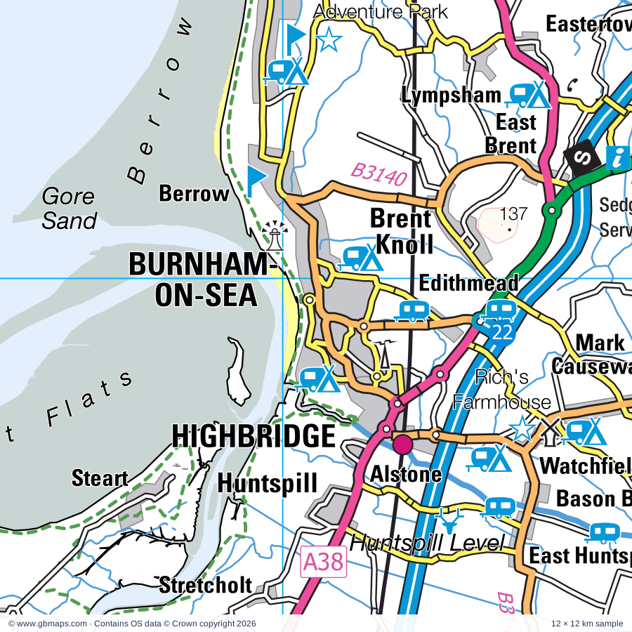
Burnham-on-Sea regional road map. Full 60 × 60 km PDF, SVG and Illustrator files, with a free PDF sample.

GBMAPS.COM

Burnham-on-Sea Regional Road Map

Call Us Now for Help01751 473136

GREAT BRITAIN ROAD ATLAS · 1:250,000 GB-330-0150

Burnham-on-Sea & surrounding area

Explore the full 60 × 60 km Burnham-on-Sea regional road map at 1:250,000, covering Wells, Weston-super-Mare, Bridgwater, Axbridge, Street. Compare the complete coverage below; a detailed PDF sample is available free.

BURNHAM-ON-SEA & SURROUNDING AREAREGIONAL ROAD MAP
60 × 60 km · Full map previewDownload the free SVG ↓

INSIDE THE FULL 60 × 60 KM MAP

Explore the Burnham-on-Sea map area

1:250,000 cartography

Towns, villages & places

More mapped places (266)
  • Highbridge
  • Alstone
  • Huntspill
  • Steart
  • Brean
  • Lympsham
  • Watchfield
  • Stretcholt
  • Bason Bridge
  • Eastertown
  • East Huntspill
  • Pawlett
  • Mark
  • Bleadon
  • Stolford
  • Otterhampton
  • Puriton
  • Combwich
  • Biddisham
  • Dunball
  • Loxton
  • Woolavington
  • Badgworth
  • Hutton
  • Christon
  • Westham
  • Coultings
  • Bawdrip
  • Cannington
  • Lower Weare
  • Cossington
  • Burtle
  • Blackford
  • Shurton
  • Locking
  • Weare
  • Stogursey
  • Cross
  • Burton
  • Wembdon
  • Fiddington
  • Chedzoy
  • Banwell
  • Edington
  • Stawell
  • Wedmore
  • Charlynch
  • Kewstoke
  • Clewer
  • Cocklake
  • Durleigh
  • Winscombe
  • Lilstock
  • Catcott
  • Stringston
  • Kilton
  • Mudgley
  • Spaxton
  • Rolstone
  • Westhay
  • Huntworth
  • Star
  • Westonzoyland
  • Cheddar
  • Goathurst
  • Enmore
  • Shipham
  • Kilve
  • Theale
  • Moorlinch
  • Bourton
  • Shapwick
  • Hewish
  • Holford
  • Puxton
  • Churchill
  • Meare
  • Draycott
  • Greinton
  • Aisholt
  • Pedwell
  • Northmoor Green
  • Ashcott
  • Courtway
  • Middlezoy
  • Broomfield
  • Congresbury
  • Henton
  • Godney
  • Burrowbridge
  • Yatton
  • Thurloxton
  • Othery
  • Hedging
  • North End
  • Crowcombe
  • Yarley
  • Pathe
  • Walton
  • Wrington
  • East Lyng
  • Easton
  • Athelney
  • Lavernock
  • Lyng
  • Bicknoller
  • Flaxpool
  • Claverham
  • Cothelstone
  • Cleeve
  • Henley
  • Durston
  • Blagdon
  • West Lyng
  • Kenn
  • Wookey
  • Stathe
  • Cushuish
  • Fulford
  • Priddy
  • Polsham
  • High Ham
  • Southway
  • Aller
  • Vellow
  • Pickney
  • Coxley
  • Redhill
  • Stogumber
  • Williton
  • Brockley
  • Ubley
  • Low Ham
  • Butcombe
  • Bathpool
  • Knapp
  • Chelvey
  • Edgarley
  • Ham
  • Staplegrove
  • Ruishton
  • Wearne
  • Dundon
  • Downside
  • Willett
  • Monksilver
  • Cotford St Luke
  • Pitney
  • Tickenham
  • Thornfalcon
  • Elworthy
  • Backwell
  • Walton in Gordano
  • Tolland
  • Washford
  • St Andrews Major
  • Dulcote
  • Regil
  • Halse
  • Farleigh
  • Drayton
  • Porthkerry
  • Tarr
  • Heathfield
  • Felton
  • Fivehead
  • Littleton
  • Swell
  • Butleigh
  • Wrantage
  • Allerford
  • Bilbrook
  • Pitsford Hill
  • Fitzhead
  • Leckwith
  • Dinder
  • Worminster
  • Weston in Gordano
  • Winford
  • Rumwell
  • Muchelney
  • Oake
  • Hillfarrance
  • Roadwater
  • Flax Bourton
  • Baltonsborough
  • Blue Anchor
  • Wenvoe
  • Trull
  • Newton
  • Wraxall
  • Thurlbear
  • Rhoose
  • West Bradley
  • Croscombe
  • Isle Abbotts
  • Long Sutton
  • Kingweston
  • Beercrocombe
  • Withycombe
  • Litton
  • Parbrook
  • Hambridge
  • Milverton
  • Carhampton
  • Langley
  • Pilton
  • Rodhuish
  • Penmark
  • Southwood
  • Dundry
  • Failand
  • Downs
  • Clatworthy
  • Stowey
  • Long Load
  • Nynehead
  • St Nicholas
  • Maundown
  • Treborough
  • Llancarfan
  • Portbury
  • Kingsdon
  • Sheepway
  • Stembridge
  • Llanbydderi
  • St Fagans
  • Gileston
  • Hornblotton
  • Witcombe
  • Stapleton
  • Coat
  • St George's
  • St Athan
  • Runnington
  • Babcary
  • Bonvilston
  • Bathealton
  • Ash
  • Llantrithyd
  • Pill
  • Chipstable
  • Leigh Woods
  • Westford
  • Flemingston
  • Lovington
  • Waterrow
  • Podimore
  • Ilchester
  • Avonmouth
  • Pendoylan
  • Yeovilton
  • Appley
  • St Hilary
  • Bridgehampton
  • Limington
  • Ashbrittle
  • Aberthin
  • Ashington
  • Clayhanger
  • Petton
  • Hallen
  • Maendy
  • Ystradowen
  • Huntsham
  • Adber

Roads across this sheet

M4, M5, M49, A4, A37, A38, A39, A48, A358, A359, A361, A368, A369, A370, A371, A372, A378, A403, A420, A469, A470, A3027, A3029, A3033

More road numbers

A3038, A3055, A3087, A3259, A3807, A4018, A4032, A4044, A4050, A4054, A4055, A4119, A4160, A4161, A4162, A4174, A4176, A4222, A4226, A4231, A4232, A4234, B3114, B3120, B3122, B3124, B3128, B3129, B3130, B3133, B3134, B3135, B3139, B3140, B3141, B3148, B3151, B3153, B3165, B3168, B3169, B3170, B3187, B3188, B3190, B3191, B3224, B3227, B3339, B3368, B3371, B3440, B4051, B4052, B4053, B4054, B4055, B4056, B4057, B4239, B4261, B4262, B4265, B4266, B4267, B4294, B4466, B4467, B4468, B4469, B4487, B4488

Rivers & waterways

Afon Ddawan / River Thaw, Bridgwater & Taunton Canal, Ely River, Floating Harbour, Nant y Dderwen-deg / Roath Brook, Rhymney River / Afon Rhymni, River Avon, River Axe, River Brue, River Cary, River Isle, River Kenn

More waterways

River Parrett, River Taff, River Tone, River Yeo, Westport Canal (disused), Whitelake

Landmarks & landscape

Abbot's Fish House, Alexander Gallery, Amelia Trust Farm, Animal Farm Adventure Park, Ashton Windmill, At-Bristol,Mayflower & SS Great Britain Historic Ship, Avalon Vineyard, Avon Gorge National Nature Reserve, Axbridge Museum, Barry Island Pleasure Park, Barry Rail Centre, Beaupre Castle, EXMOOR NATIONAL PARK

More named features

Bishop's Palace, Blaise Castle Estate, Blaise Castle Museum, Blue Reef Aquarium, Brean Down Fort, Bristol Cathedral, Clifton Cathedral, Bristol Zoo, Burcot Mill, Burrington Ham and Blackdown Common Nature Reserve, Caisson, Cardiff Castle, Chalice Well Gardens, Chapter Arts Centre, Llanover Hall Arts Centre, Cleeve Abbey, Clevedon Court, Clevedon Craft Centre, Clifton Suspension Bridge, SS Great Britain, Coleridge Cottage, Combe Sydenham Country Park, Cosmeston Lakes Country Park, Cosmeston Medieval Village, Cothay Manor, Court Farm Park, Coxley Vineyard, Crook Peak and Wavering Down Nature Reserve, Crystal Quest, Daws Castle, Doctor Who Experience, Dolebury Warren Nature Reserve, Dyffryn Gardens, Flat Holm Nature Reserve, Fleet Air Arm Museum, Fonmon Castle, Fyne Court Nature Reserve & Visitor Centre, Glastonbury Abbey, Glastonbury Tor-Chalice Well, Glastonbury Tribunal, Grand Pier, Hartcliffe Community Park Farm, Hestercombe House Gardens, Ilchester Town Museum, International Helicopter Museum, International Sports Venue, Canoeing & Rafting, Kingsweston Down Nature Reserve, Langport & River Parrett Visitor Centre, Llandaff Cathedral, Cardiff Cathedral, Llanerch Vineyard, London Cigarette Card Museum, Long Cairn, Lyte's Cary Manor, Makers Guild in Wales-Craft in the Bay, Maunsel Canal Centre, Milton Lodge Garden, Moorlynch Vineyard Crafts, Muchelney Abbey, National Animal Welfare Trust, National Indoor Athletics Centre, National Museum & Gallery, Welch Regiment Museum, Butetown History and Arts Centre, Noah's Ark Zoo Farm, North Somerset Museum, Oakham Treasures Museum, Pilton Manor Vineyard, Porthkerry Country Park, Priest's House, Puxton Park, Rich's Farmhouse Cider Farm, Sand Point and Middle Hope Nature Reserve, Secret World of Wildlife, Sheppy's Cider Farm Centre, Solar Farm, Somerset Brick and Tile Museum, Admiral Blake Museum, Somerset Cricket Museum, Museum of Somerset, Somerset Guild of Craftsmen, Somerset Rural Life Museum, St Fagans National History Museum, St Lythans Burial Chamber, Stembridge Tower Mill, Taunton Racecourse, Techniquest, The Assembly at the Pierhead, Norwegian Church Arts Centre,Dr Who Experience, Motorpoint Arena, Temple Church, Temple of Harmony, The Bakelite Museum, The Cheddar Gorge Cheese Company, The Gauge Museum, The Shoe Museum, The Walled Gardens of Cannington, Tinkinswood Burial Chamber, Tintinhull House Gardens, Torre Cider Farm, Tropical Bird Garden, Tropiquaria Wildlife Park, Turner House Gallery, Tyntesfield, Vellow Pottery, Vigo Wood Nature Reserve, Visitor Centre, Warren Mill Farm Park, Watchet Boat Museum, The Market House Museum, Wellington Museum, Wellington Park Botanical Gardens, Wells Cathedral, Wells Museum, Welsh Hawking Centre, West Sedgemoor Nature Reserve, West Somerset Railway, West Somerset Railway Museum, Westhay Moor Nature Reserve, Weston-Super-Mare Sea Aquarium, Westonzoyland Pumping Station Museum, Willows & Wetlands Visitor Centre, Windmill Hill City Farm, Woodspring Priory, Wookey Hole Papermill
Local authority & parish coverage

Wholly or partly within the full map rectangle. These boundaries are coverage information, not additional artwork layers.

  • Bath and North East SomersetPartly within
  • Bro Morgannwg - the Vale of GlamorganPartly within
  • Caerdydd - CardiffPartly within
  • Casnewydd - NewportPartly within
  • City of BristolPartly within
  • DorsetPartly within
  • Mid Devon DistrictPartly within
  • North SomersetWholly within
  • Rhondda Cynon Taf - Rhondda Cynon TafPartly within
  • SomersetPartly within
  • South GloucestershirePartly within
Wards & electoral divisions 160 areas
  • Ashley Ward (part)
  • Avonmouth & Lawrence Weston Ward (part)
  • Backwell Ward
  • Banwell & Winscombe Ward
  • Bedminster Ward
  • Bishopston & Ashley Down Ward (part)
  • Bishopsworth Ward
  • Blagdon & Churchill Ward
  • Canonsleigh Ward (part)
  • Central Ward
  • Charlton & Cribbs Ward (part)
  • Chew Valley Ward (part)
  • Clare & Shuttern Ward (part)
  • Clevedon East Ward
  • Clevedon South Ward
  • Clevedon Walton Ward
  • Clevedon West Ward
  • Clevedon Yeo Ward
  • Clifton Down Ward
  • Clifton Ward
  • Congresbury & Puxton Ward
  • Cotham Ward
  • Filton Ward (part)
  • Filwood Ward (part)
  • Gordano Valley Ward
  • Hartcliffe & Withywood Ward
  • Henbury & Brentry Ward
  • Hengrove & Whitchurch Park Ward (part)
  • Horfield Ward (part)
  • Hotwells & Harbourside Ward
  • Hutton & Locking Ward
  • Knowle Ward (part)
  • Lawrence Hill Ward (part)
  • Lockleaze Ward (part)
  • Long Ashton Ward
  • Mendip Ward (part)
  • Nailsea Golden Valley Ward
  • Nailsea West End Ward
  • Nailsea Yeo Ward
  • Nailsea Youngwood Ward
  • Pill Ward
  • Pilning & Severn Beach Ward (part)
  • Portishead East Ward
  • Portishead North Ward
  • Portishead South Ward
  • Portishead West Ward
  • Publow & Whitchurch Ward (part)
  • Redland Ward
  • Sherborne Rural Ward (part)
  • Southmead Ward
  • Southville Ward
  • Stoke Bishop Ward
  • Westbury-on-Trym & Henleaze Ward
  • Weston-super-Mare Central Ward
  • Weston-super-Mare Hillside Ward
  • Weston-super-Mare Kewstoke Ward
  • Weston-super-Mare Mid Worle Ward
  • Weston-super-Mare Milton Ward
  • Weston-super-Mare North Worle Ward
  • Weston-super-Mare South Ward
  • Weston-super-Mare South Worle Ward
  • Weston-super-Mare Uphill Ward
  • Weston-super-Mare Winterstoke Ward
  • Wick St. Lawrence & St. Georges Ward
  • Windmill Hill Ward (part)
  • Winford Ward
  • Wrington Ward
  • Yatton Ward
  • Adamsdown ED
  • Baruc ED
  • Bishop's Hull & Taunton West ED
  • Blackdown & Neroche ED (part)
  • Brent ED
  • Bridgwater East & Bawdrip ED
  • Bridgwater North & Central ED
  • Bridgwater South ED
  • Bridgwater West ED
  • Brympton ED (part)
  • Burnham on Sea North ED
  • Butetown ED
  • Buttrills ED
  • Cadoc ED
  • Caerau ED
  • Cannington ED
  • Canton ED
  • Castle Cary ED (part)
  • Castleland ED
  • Cathays ED
  • Cheddar ED
  • Comeytrowe & Trull ED
  • Cornerswell ED
  • Court ED
  • Cowbridge ED (part)
  • Curry Rivel & Langport ED (part)
  • Cyncoed ED (part)
  • Dinas Powys ED
  • Dulverton & Exmoor ED (part)
  • Dunster ED (part)
  • Dyfan ED
  • Ely ED
  • Fairwater ED
  • Gabalfa ED
  • Gibbonsdown ED
  • Glastonbury ED
  • Grangetown ED
  • Heath ED (part)
  • Highbridge & Burnham South ED
  • Huntspill ED
  • Illtyd ED
  • King Alfred ED
  • Llandaff ED
  • Llandaff North ED
  • Llandough ED
  • Llanharry ED (part)
  • Llanrumney ED (part)
  • Llantwit Major ED (part)
  • Llanwern ED (part)
  • Lydeard ED
  • Martock ED (part)
  • Mendip Hills ED (part)
  • Mendip South ED (part)
  • Mendip West ED
  • Monkton & North Curry ED
  • North Petherton ED
  • Pentwyn ED (part)
  • Pentyrch and St. Fagans ED (part)
  • Penylan ED
  • Peterston-super-Ely ED (part)
  • Plasnewydd ED
  • Plymouth ED
  • Pontyclun Central ED (part)
  • Pontyclun East ED (part)
  • Pontyclun West ED (part)
  • Radyr ED (part)
  • Rhoose ED
  • Riverside ED
  • Rowbarton & Staplegrove ED
  • Rumney ED (part)
  • Shepton Mallet ED (part)
  • Somerton ED
  • South Petherton & Islemoor ED (part)
  • Splott ED
  • St. Athan ED (part)
  • St. Augustine's ED
  • St. Nicholas and Llancarfan ED
  • Stanwell ED
  • Street ED
  • Sully ED
  • Taunton East ED
  • Taunton North ED
  • Taunton South ED
  • Tredegar Park and Marshfield ED (part)
  • Trowbridge ED (part)
  • Upper Tone ED (part)
  • Watchet & Stogursey ED
  • Wellington ED (part)
  • Wells ED
  • Wenvoe ED
  • Whitchurch and Tongwynlais ED (part)
  • Yeovil West ED (part)
Civil parishes & communities 309 areas
  • Abbots Leigh CP
  • Adamsdown Community
  • Alford CP (part)
  • Aller CP
  • Almondsbury CP (part)
  • Ash CP (part)
  • Ash Priors CP
  • Ashbrittle CP
  • Ashcott CP
  • Axbridge CP
  • Babcary CP
  • Backwell CP
  • Badgworth CP
  • Baltonsborough CP
  • Bampton CP (part)
  • Banwell CP
  • Barrington CP (part)
  • Barrow Gurney CP
  • Barry Community
  • Barton St. David CP
  • Bathealton CP
  • Bawdrip CP
  • Beercrocombe CP (part)
  • Berrow CP
  • Bickenhall CP (part)
  • Bicknoller CP
  • Bishop's Hull CP
  • Bishop's Lydeard CP
  • Blagdon CP
  • Bleadon CP
  • Bradford-on-Tone CP
  • Brean CP
  • Brent Knoll CP
  • Bridgwater CP
  • Bridgwater Without CP
  • Brockley CP
  • Brompton Ralph CP
  • Brompton Regis CP (part)
  • Broomfield CP
  • Burnham Without CP
  • Burnham-on-Sea and Highbridge CP
  • Burrington CP
  • Burrowbridge CP
  • Burtle CP
  • Butcombe CP
  • Butetown Community
  • Butleigh CP
  • Caerau Community
  • Cannington CP
  • Canton Community
  • Carhampton CP (part)
  • Castle Community
  • Catcott CP
  • Cathays Community
  • Chapel Allerton CP
  • Charlton Hayes CP (part)
  • Cheddar CP
  • Cheddon Fitzpaine CP
  • Chedzoy CP
  • Chew Magna CP (part)
  • Chew Stoke CP
  • Chewton Mendip CP (part)
  • Chilthorne Domer CP (part)
  • Chilton Cantelo CP
  • Chilton Polden CP
  • Chilton Trinity CP
  • Chipstable CP
  • Churchill CP
  • Clapton-in-Gordano CP
  • Clatworthy CP
  • Clayhanger CP
  • Cleeve CP
  • Clevedon CP
  • Combe Florey CP
  • Compton Bishop CP
  • Compton Dundon CP
  • Compton Martin CP
  • Congresbury CP
  • Corfe CP (part)
  • Cossington CP
  • Cotford St. Luke CP
  • Cothelstone CP
  • Cowbridge with Llanblethian Community (part)
  • Creech St. Michael CP
  • Croscombe CP (part)
  • Crowcombe CP
  • Curry Mallet CP (part)
  • Curry Rivel CP
  • Cyncoed Community (part)
  • Dinas Powys Community
  • Ditcheat CP (part)
  • Drayton CP
  • Dundry CP
  • Dunster CP (part)
  • Durleigh CP
  • Durston CP
  • East Brent CP
  • East Harptree CP
  • East Huntspill CP
  • East Pennard CP (part)
  • East Quantoxhead CP
  • Edington CP
  • Elworthy CP
  • Ely Community
  • Emborough CP (part)
  • Enmore CP
  • Fairwater Community
  • Fiddington CP
  • Filton CP (part)
  • Fitzhead CP
  • Fivehead CP
  • Flax Bourton CP
  • Gabalfa Community
  • Glastonbury CP
  • Goathurst CP
  • Godney CP
  • Grangetown Community
  • Greinton CP
  • Halse CP
  • Hambridge and Westport CP (part)
  • Hatch Beauchamp CP (part)
  • Heath Community (part)
  • High Ham CP
  • Hinton Blewett CP (part)
  • Hockworthy CP (part)
  • Holcombe Rogus CP (part)
  • Holford CP
  • Huish Champflower CP
  • Huish Episcopi CP
  • Huntsham CP (part)
  • Hutton CP
  • Ilchester CP
  • Isle Abbotts CP (part)
  • Isle Brewers CP (part)
  • Keinton Mandeville CP
  • Kenn CP
  • Kewstoke CP
  • Kilve CP
  • Kingsbury Episcopi CP (part)
  • Kingsdon CP
  • Kingston Seymour CP
  • Kingston St. Mary CP
  • Kingweston CP
  • Langford Budville CP
  • Langport CP
  • Litton CP (part)
  • Llancarfan Community
  • Llandaff Community
  • Llandaff North Community
  • Llandough Community
  • Llanedeyrn Community (part)
  • Llanfair Community (part)
  • Llanharry Community (part)
  • Llanmaes Community (part)
  • Llanrumney Community (part)
  • Llantwit Major Community (part)
  • Locking CP
  • Long Ashton CP
  • Long Load CP
  • Long Sutton CP
  • Lovington CP (part)
  • Loxton CP
  • Luxborough CP (part)
  • Lydeard St. Lawrence CP
  • Lydford-on-Fosse CP
  • Lympsham CP
  • Lyng CP
  • Mark CP
  • Marston Magna CP (part)
  • Martock CP (part)
  • Meare CP
  • Michaelston-le-Pit and Leckwith Community
  • Middlezoy CP
  • Milverton CP
  • Monksilver CP
  • Moorlinch CP
  • Muchelney CP
  • Mudford CP (part)
  • Nailsea CP
  • Nempnett Thrubwell CP
  • Nether Stowey CP
  • Nettlecombe CP
  • North Barrow CP (part)
  • North Curry CP
  • North Petherton CP
  • North Wootton CP
  • Norton Fitzwarren CP
  • Norton Malreward CP (part)
  • Nynehead CP
  • Oake CP
  • Old Cleeve CP
  • Orchard Portman CP (part)
  • Othery CP
  • Otterhampton CP
  • Over Stowey CP
  • Pawlett CP
  • Penarth Community
  • Pendoylan Community (part)
  • Penllyn Community (part)
  • Pentyrch Community (part)
  • Penylan Community
  • Peterston-super-Ely Community
  • Pill and Easton-in-Gordano CP
  • Pilton CP (part)
  • Pitminster CP (part)
  • Pitney CP
  • Pont-y-clun Community (part)
  • Pontcanna Community
  • Portbury CP
  • Portishead CP
  • Priddy CP
  • Puriton CP
  • Puxton CP
  • Pylle CP (part)
  • Queen Camel CP (part)
  • Radyr and Morganstown Community (part)
  • Redwick Community (part)
  • Rhoose Community
  • Rimpton CP (part)
  • Riverside Community
  • Roath Community
  • Rodney Stoke CP
  • Ruishton CP
  • Rumney Community (part)
  • Sampford Brett CP
  • Shapwick CP
  • Sharpham CP
  • Shepton Mallet CP (part)
  • Shipham CP
  • Skilgate CP (part)
  • Somerton CP
  • South Barrow CP (part)
  • Sparkford CP (part)
  • Spaxton CP
  • Splott Community
  • St. Athan Community (part)
  • St. Cuthbert Out CP (part)
  • St. Fagans Community (part)
  • St. Georges CP
  • St. Georges-super-Ely Community
  • St. Nicholas and Bonvilston Community
  • Stanton Drew CP (part)
  • Stawell CP
  • Stawley CP (part)
  • Stockland Bristol CP
  • Stogumber CP
  • Stogursey CP
  • Stoke St. Gregory CP
  • Stoke St. Mary CP
  • Stowey-Sutton CP (part)
  • Street CP
  • Stringston CP
  • Sully and Lavernock Community
  • Taunton CP
  • Temple Cloud with Cameley CP (part)
  • The Charltons CP
  • Thornfalcon CP
  • Thurloxton CP
  • Tickenham CP
  • Tintinhull CP (part)
  • Tolland CP
  • Treborough CP (part)
  • Tremorfa Community
  • Trent CP (part)
  • Trowbridge Community (part)
  • Trull CP
  • Ubley CP
  • Upton CP (part)
  • Walton CP
  • Walton-in-Gordano CP
  • Watchet CP
  • Weare CP
  • Wedmore CP
  • Wellington CP (part)
  • Wellington Without CP (part)
  • Wells CP
  • Welsh St. Donats Community
  • Wembdon CP
  • Wentlooge Community (part)
  • Wenvoe Community
  • West Bagborough CP
  • West Bradley CP (part)
  • West Buckland CP (part)
  • West Camel CP
  • West Harptree CP
  • West Hatch CP (part)
  • West Huntspill CP
  • West Monkton CP
  • West Pennard CP
  • West Quantoxhead CP
  • Westbury CP
  • Weston-Super-Mare CP
  • Weston-in-Gordano CP
  • Westonzoyland CP
  • Whitchurch CP (part)
  • Whitchurch Community (part)
  • Wick St. Lawrence CP
  • Williton CP
  • Winford CP
  • Winscombe and Sandford CP
  • Withycombe CP (part)
  • Wiveliscombe CP
  • Wookey CP
  • Woolavington CP
  • Wraxall and Failand CP
  • Wrington CP
  • Yatton CP
  • Yeovil Without CP (part)
  • Yeovilton and District CP (part)

Source: the GBMaps road atlas, OS Boundary-Line and postcode mapping datasets. Source editions are being checked for publication. Unmarked boundary names are wholly within the sheet; “part” means the map edge crosses the area.

Place lists are selected from the map source, not a complete gazetteer. Named features describe the cartography; visitor facilities and opening status are not verified. The free sample covers only 12 × 12 km of this larger sheet.

INSIDE YOUR DOWNLOAD

A proper road map, in useful formats

Road classifications, towns and villages, railways, rivers, landscape detail and tourist symbols, brought together in the GBMaps regional road atlas style.

PDF filePDFSVG fileSVGAdobe Illustrator AI fileAi

PDF for the finished map. SVG and layered Illustrator artwork for adapting colours, adding your own information and preparing designs.

THE FINISHED SHEET

Designed for print and presentation

Map coverage
60 × 60 km
Sample coverage
12 × 12 km
Print layout
A3 landscape · enlarged 1:250k cartography
Sheet furniture
Border, scale bar, key & north arrow

A few useful details

What changes when I select another square?

Select a surrounding square to bring it into the centre and reveal the maps around it. Each square is a different 60 × 60 km map. The preview, free sample and selected download change together. Neighbouring sheets overlap by 30 km so you can choose the coverage that suits you.

Is the free sample a vector map?

The on-page detail is an SVG. The free download is a separate 12 × 12 km PDF with a link to the full map. Please retain its copyright credits and product link when sharing it.

Can I buy a larger combined map?

These downloads are individual ready-made sheets. Contact GBMaps if you need a larger combined area.

FREE PDF SAMPLE

Your free map sample

Your free 12 × 12 km sample includes a link back to this map, so you can return for the full area whenever you need it.

Download free PDF sample ↓

Get your Burnham-on-Sea map

Map download bundle

£24.00including VATOne payment

Pay securely

One payment. Your map stays open.

Your map download

Your map files

Preparing your download…

Checking your private download link…

Your map downloads

Already bought a map?

Find the downloads from your purchases.

Enter the email address you used at checkout. We’ll email you a private link to your available map downloads.