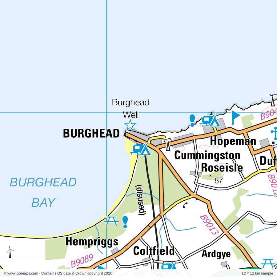
Burghead regional road map. Full 60 × 60 km PDF, SVG and Illustrator files, with a free PDF sample.

GBMAPS.COM

Burghead Regional Road Map

Call Us Now for Help01751 473136

GREAT BRITAIN ROAD ATLAS · 1:250,000 GB-300-0870

Burghead & surrounding area

Explore the full 60 × 60 km Burghead regional road map at 1:250,000, covering Burghead, Forres, Elgin, Lossiemouth, Tain. Compare the complete coverage below; a detailed PDF sample is available free.

BURGHEAD & SURROUNDING AREAREGIONAL ROAD MAP
60 × 60 km · Full map previewDownload the free SVG ↓

INSIDE THE FULL 60 × 60 KM MAP

Explore the Burghead map area

1:250,000 cartography

Towns, villages & places

More mapped places (96)
  • Hopeman
  • Balintore
  • Rafford
  • Rockfield
  • Shandwick
  • Califer
  • Alves
  • Whitemire
  • Kingsteps
  • Conicavel
  • Portmahomack
  • Auldearn
  • Duffus
  • Fearn
  • Rhynie
  • Inver
  • Covesea
  • Quarrywood
  • Logie
  • Hill of Fearn
  • Pitcalnie
  • Nigg
  • Nigg Ferry
  • Miltonduff
  • Loandhu
  • Arabella
  • Pittendreich
  • Dallas
  • Moss-side
  • Littlemill
  • Regoul
  • Newfield
  • Kellas
  • Piperhill
  • Redburn
  • Kildary
  • Milton
  • Culcharry
  • Kilmuir
  • Thomshill
  • Ferness
  • Barbaraville
  • Glenlatterach
  • Cawdor
  • Pollo
  • Davidston
  • Longmorn
  • Lochside
  • Ardersier
  • Balintraid
  • Delny
  • Clephanton
  • Lamington
  • Fogwatt
  • Whitewreath
  • Achindown
  • Quarryhill
  • Scotsburn
  • Jemimaville
  • Lhanbryde
  • Croy
  • Rosemarkie
  • Lochhill
  • Urquhart
  • Embo
  • Lonemore
  • Balblair
  • Tomich
  • Camore
  • Raddery
  • Tornagrain
  • Fourpenny
  • Cantraywood
  • Evelix
  • Poles
  • Clashmore
  • Altonside
  • Littleferry
  • Balleigh
  • Edderton
  • Skelbo
  • Newton
  • Avoch
  • Badninish
  • Astle
  • Ardmore
  • Knockando
  • Golspie
  • Whiteface
  • Archiestown
  • Kirkton
  • Rearquhar
  • Robertstown
  • Carron
  • Little Torboll
  • Craigellachie

Roads across this sheet

A95, A832, A836, A839, A939, A940, A941, A949, B817, B851, B9006, B9007, B9010, B9011, B9012, B9013, B9015, B9039, B9040, B9089, B9090, B9091, B9092, B9101

More road numbers

B9102, B9111, B9135, B9160, B9163, B9165, B9166, B9168, B9174, B9175, B9177

Rivers & waterways

Abhainn an t-Sratha Charnaig, Allt Dearg, Allt a Gheallaidh, Black Burn, Burn of Rothes, Dorback Burn, Leanoch Burn, Leonach Burn, Muckle Burn, Riereach Burn, River Divie, River Evelix

More waterways

River Fiddich, River Findhorn, River Fleet, River Lossie, River Nairn, River Spey, Spynie Canal, Tomlachlan Burn

Landmarks & landscape

Aberlour Distillery, Aldie Water Mill, Altyre House, Anta Pottery, Ardclach Bell Tower, Arndilly House, Balblair Distillery, Balnagown Castle, Ben M Nature Reserve, Benromach Distillery, Benromach Distillery, Visitor Centre, Blervie Castle

More named features

Bogbain Adventure and Heritage Farm, Brodie Castle, Burghead Well, Cambusmore Lodge, Cardhu Distillery, Castle Stuart, Cawder Castle, Cawdor Castle and Gardens, Clava Cairns, Cooperage, Cromarty Courthouse Museum, Culbin Forest Nature Reserve, Culloden Battlefield Visitor Centre, Dailluaine Distillery, Dallas Dhu Distillery, Distillery, Dornoch Cathedral, Elgin Cathedral, Elgin Kart Raceway, Elgin Museum, Moray Motor Museum, Falconer Museum, Findhorn Bay Local Nature Reserve, Findhorn Foundation, Findhorn Heritage Centre, Fort George, Fortrose Cathedral, Geanies House, Geddes House, Glasstorm Glass Workshop and Gallery, Glen Grant Distillery, Glen Moray Distillery, Glen Moray Distillery, Visitor Centre, Glenferness House, Glenmorangie Distillery, Glenmorangie Distillery Visitor Centre, Gordonstoun, Grange Hall, Groam House Museum, Hilton of Cadboll (chapel), Historylinks Museum, House of Daviot, Hugh Miller's Cottage, Imperial Distillery, Invergordon Heritage Centre, Kilravock Castle, Kincorth House, King's Cave, Knockando Distillery, Knockando House, Leuchars House, Linkwood Distillery, Logie Steading CraftCentre, Logie Steading Visitor Centre, Longmorn Distillery, Lossiemouth Fishery and Community Museum, Macallan Distillery, McFarquhar's Cave, Millbuies Country Park, Miltonduff Distillery, Motte and Dovecot, Moy House, Nature Reserve, Old Duffus Castle, Old Glennan, Other Tourist Attraction, Palace of Spynie, Pluscarden Abbey, Randolph's Leap, Royal Brackla Distillery, Shandwick Stone, Speyside Way Visitor Centre, St Peter's Kirk, Stone, Sueno's Stone, Symbol Stone, Tain Through Time, Tamdhu Distillery, Tarbat Discovery Centre, Tarbat House, The Biblical Garden, The Highlanders Regimental Museum, The Nairn Museum, Piccolo Printing Museum, Tower, Urquhart Pottery, Wool Mill
Local authority & parish coverage

Wholly or partly within the full map rectangle. These boundaries are coverage information, not additional artwork layers.

  • HighlandPartly within
  • MorayPartly within
Wards & electoral divisions 16 areas
  • Aird and Loch Ness Ward (part)
  • Badenoch and Strathspey Ward (part)
  • Black Isle Ward (part)
  • Cromarty Firth Ward (part)
  • Culloden and Ardersier Ward (part)
  • East Sutherland and Edderton Ward (part)
  • Elgin City North Ward
  • Elgin City South Ward
  • Fochabers Lhanbryde Ward (part)
  • Forres Ward (part)
  • Heldon and Laich Ward
  • Inverness Millburn Ward (part)
  • Inverness South Ward (part)
  • Nairn and Cawdor Ward (part)
  • Speyside Glenlivet Ward (part)
  • Tain and Easter Ross Ward (part)
Civil parishes & communities 0 areas

    Source: the GBMaps road atlas, OS Boundary-Line and postcode mapping datasets. Source editions are being checked for publication. Unmarked boundary names are wholly within the sheet; “part” means the map edge crosses the area.

    Place lists are selected from the map source, not a complete gazetteer. Named features describe the cartography; visitor facilities and opening status are not verified. The free sample covers only 12 × 12 km of this larger sheet.

    INSIDE YOUR DOWNLOAD

    A proper road map, in useful formats

    Road classifications, towns and villages, railways, rivers, landscape detail and tourist symbols, brought together in the GBMaps regional road atlas style.

    PDF filePDFSVG fileSVGAdobe Illustrator AI fileAi

    PDF for the finished map. SVG and layered Illustrator artwork for adapting colours, adding your own information and preparing designs.

    THE FINISHED SHEET

    Designed for print and presentation

    Map coverage
    60 × 60 km
    Sample coverage
    12 × 12 km
    Print layout
    A3 landscape · enlarged 1:250k cartography
    Sheet furniture
    Border, scale bar, key & north arrow

    A few useful details

    What changes when I select another square?

    Select a surrounding square to bring it into the centre and reveal the maps around it. Each square is a different 60 × 60 km map. The preview, free sample and selected download change together. Neighbouring sheets overlap by 30 km so you can choose the coverage that suits you.

    Is the free sample a vector map?

    The on-page detail is an SVG. The free download is a separate 12 × 12 km PDF with a link to the full map. Please retain its copyright credits and product link when sharing it.

    Can I buy a larger combined map?

    These downloads are individual ready-made sheets. Contact GBMaps if you need a larger combined area.

    FREE PDF SAMPLE

    Your free map sample

    Your free 12 × 12 km sample includes a link back to this map, so you can return for the full area whenever you need it.

    Download free PDF sample ↓

    Get your Burghead map

    Map download bundle

    £24.00including VATOne payment

    Pay securely

    One payment. Your map stays open.

    Your map download

    Your map files

    Preparing your download…

    Checking your private download link…

    Your map downloads

    Already bought a map?

    Find the downloads from your purchases.

    Enter the email address you used at checkout. We’ll email you a private link to your available map downloads.