Bristol regional road map. Full 60 × 60 km PDF, SVG and Illustrator files, with a free PDF sample.

GBMAPS.COM

Bristol Regional Road Map

Call Us Now for Help01751 473136

GREAT BRITAIN ROAD ATLAS · 1:250,000 GB-360-0180

Bristol & surrounding area

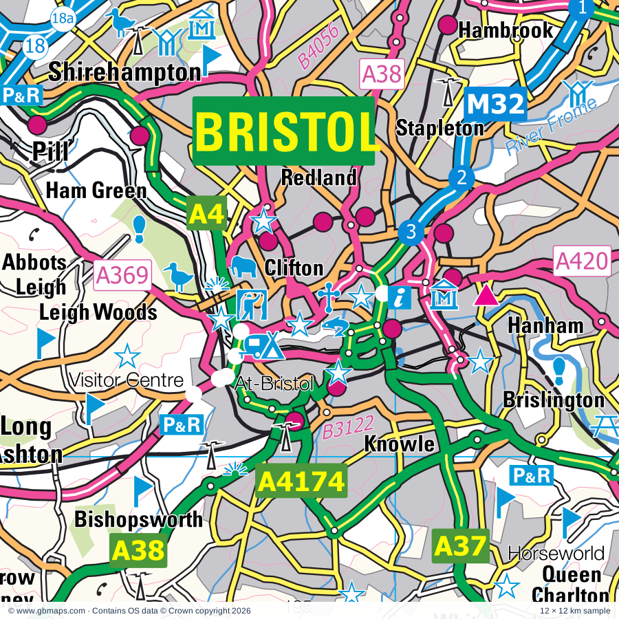
Explore the full 60 × 60 km Bristol regional road map at 1:250,000, covering Filton, Thornbury, Yate, Keynsham, Caldicot. Compare the complete coverage below; a detailed PDF sample is available free.

BRISTOL & SURROUNDING AREAREGIONAL ROAD MAP
60 × 60 km · Full map previewDownload the free SVG ↓

INSIDE THE FULL 60 × 60 KM MAP

Explore the Bristol map area

1:250,000 cartography

Towns, villages & places

More mapped places (357)

Roads across this sheet

M4, M5, M32, M48, M49, A4, A36, A37, A38, A39, A46, A48, A320, A350, A361, A362, A363, A365, A366, A367, A368, A369, A370, A371

More road numbers

A403, A419, A420, A431, A432, A433, A466, A472, A3029, A3033, A3039, A3062, A3098, A3102, A3604, A4017, A4018, A4032, A4042, A4044, A4051, A4135, A4162, A4171, A4173, A4174, A4175, A4176, A4320, A4810, B3019, B3090, B3097, B3098, B3099, B3105, B3106, B3107, B3108, B3109, B3110, B3111, B3114, B3115, B3116, B3118, B3119, B3120, B3122, B3124, B3128, B3129, B3130, B3133, B3134, B3135, B3139, B3140, B3151, B3169, B3353, B3355, B3356, B3368, B3371, B3440, B4008, B4014, B4039, B4040, B4046, B4048, B4051, B4052, B4053, B4054, B4055, B4056, B4057, B4058, B4059, B4060, B4061, B4062, B4064, B4066, B4070, B4071, B4073, B4228, B4231, B4234, B4235, B4236, B4237, B4239, B4240, B4245, B4293, B4427, B4461, B4465, B4466, B4467, B4468, B4469, B4509, B4591, B4596, B4598

Rivers & waterways

Ebbw River / Afon Ebwy, Floating Harbour, Gloucester & Sharpness Canal, Kennet & Avon Canal, Malpas Brook, Monmouthshire & Brecon Canal, Nant Olwy/ Olway Brook, River Avon, River Axe, River Frome, River Kenn, River Usk / Afon Wsyg

More waterways

River Wye, River Wye / Afon Gwy, River Yeo, Stroudwater Canal (disused), Thames & Severn Canal (disused), The Feeder

Landmarks & landscape

Abbey Tintern Furnace, Alexander Gallery, American Museum in Britain, Animal Farm Adventure Park, Assembly Rooms, Royal Crescent, The Circus, Thermae Bath Spa, At-Bristol,Mayflower & SS Great Britain Historic Ship, Avon Gorge National Nature Reserve, Avon Valley Country Park, Avon Valley Railway, Avon Valley Wildlife Park, Axbridge Museum, Barton Farm Country Park, BRECON BEACONS NATIONAL PARK

More named features

Bath Abbey, Bath Racecourse, Beckford's Tower, Berkeley Castle, Berkley Castle Gardens, Blaise Castle Estate, Blaise Castle Museum, Bliss Meadows, Blue Reef Aquarium, Bradford on Avon Museum, Bradford-on-Avon Tithe Barn, Bristol Blue Glass, Bristol Cathedral, Clifton Cathedral, Bristol Zoo, Brokerswood Country Park, Burrington Ham and Blackdown Common Nature Reserve, Caerleon Roman Fort, Caldicot Castle & Museum, Caldicot Castle Country Park, Canal Visitor Centre, Castle Combe Motor Racing Circuit, Castle Combe Museum, Cattle Country Adventure Park, Chavenage House, Chepstow Castle, Chepstow Museum, Chepstow Racecourse, City Museum & Art Gallery, M Shed Museum, Georgian House, Harvey's Wine Museum, City of Bath (World Heritage Site), Clanger and Picket Wood Nature Reserve, Clevedon Court, Clevedon Craft Centre, Clifton Suspension Bridge, SS Great Britain, Corsham Court, Corsham Court and Gardens, Corsham Gardens, Cotswolds Canal Heritage Centre, Court Farm Park, Craft Centre, Crook Peak and Wavering Down Nature Reserve, Crystal Quest, Dean Forest Railway, Dean Forest Railway Museum, Dean Heritage Centre, Dewstow Gardens, Dolebury Warren Nature Reserve, Dr Jenner's House, Dursley Heritage Centre, Dyrham Park, Farleigh Castle, Farleigh Hungerford Castle, Folly Farm Nature Reserve, Frocester Hill, Gatehouse, Georgian Garden, Go Ape Forest of Dean, Severnwye Llama Trekking, Goytre Wharf, Grand Pier, Great Chalfield Manor, Green Lane Wood Nature Reserve, Smiths Well Wood Nature Reserve, Gwent Rural Life Museum, Hartcliffe Community Park Farm, Hetty Pegler's Tump, Hinton Priory, Holburne Museum & Crafts Study Centre, Bath Postal Museum, William Herschel Museum, Building of Bath Museum, The Jane Austin Centre, Science Museum, Horseworld, Horton Court, International Helicopter Museum, Jack Russell Gallery, Kingsweston Down Nature Reserve, Kingswood Abbey Gate (ruin), Langstone Solar Farm, Large Solar Farm, Llandegfedd Visitor Centre, Llanmelin Wood Hillforts, Llantarnam Abbey, Lydney Park House, Midger Wood Nature Reserve, Museum of Bath at Work, No 1 Royal Crescent, Sally Lunn's Kitchen Museum, Museum of Costume, The Roman Baths, Museum of East Asian Art, Nagshead Nature Reserve, Nature Reserve, Newark Park, Newport Museum & Art Gallery, Noah's Ark Zoo Farm, North Somerset Museum, Nympsfield Long Barrow, Oakham Treasures Museum, Offa's Dyke, Oldbury Court Estate, Perrygrove Miniature Railway, Prior Park Landscape Garden, Puxton Park, Puzzle Wood, Radstock & District Museum, Raglan Castle, Roman Amphitheatre, Roman Baths Museum, Roman Legionary Museum, Runstan Chapel (remains of), Sand Point and Middle Hope Nature Reserve, Sheldon Manor Gardens, Sir Bevil Grenville's Monument, Solar Farm, Somerset and Dorset Heritage Railway, Southwick Country Park, St Briavels Castle, St Laurence Church, St Woolos Cathedral, Stanton Drew Stone Circles, Stoney Littleton Long Barrow, Stroud Museum, The Museum in the Park, Temple Church, Tetbury Police Museum, The Bath Aqua Theatre of Glass, The Cheddar Gorge Cheese Company, The Courts Garden, The Forest of Dean Model Village, The Peto Garden, Thisledown, Thornbury Museum, Tintern Abbey, Tithe Barn, Tropical Bird Garden, Trowbridge Museum, Tyndale Monument, Tyntesfield, Uley Long Barrow (Hetty Pegler's Tump), Usk Castle, Veddw House Garden, Venta Silvrvm Roman Town, Visitor Centre, Westbury Solar Farm, Westbury White Horse (Hill Figure), Weston-Super-Mare Sea Aquarium, Westonbirt Arboretum, Westwood Manor, Wetmoor Nature Reserve, Wild Place Project, Wildfowl and Wetlands Trust, Willsbridge Mill, Windmill Hill City Farm, Woodchester Mansion & Park, Woodspring Priory, Wotton Heritage Centre, Yate Heritage Centre
Local authority & parish coverage

Wholly or partly within the full map rectangle. These boundaries are coverage information, not additional artwork layers.

  • Bath and North East SomersetWholly within
  • Casnewydd - NewportPartly within
  • City of BristolPartly within
  • Cotswold DistrictPartly within
  • Forest of Dean DistrictPartly within
  • North SomersetPartly within
  • Sir Fynwy - MonmouthshirePartly within
  • SomersetPartly within
  • South GloucestershireWholly within
  • Stroud DistrictPartly within
  • Torfaen - TorfaenPartly within
  • WiltshirePartly within
Wards & electoral divisions 257 areas
  • Amberley and Woodchester Ward
  • Ashley Ward
  • Avonmouth & Lawrence Weston Ward (part)
  • Backwell Ward
  • Banwell & Winscombe Ward
  • Bathavon North Ward
  • Bathavon South Ward
  • Bathwick Ward
  • Bedminster Ward
  • Berkeley Vale Ward
  • Bishopston & Ashley Down Ward
  • Bishopsworth Ward
  • Bisley Ward (part)
  • Bitton & Oldland Common Ward
  • Blagdon & Churchill Ward
  • Boyd Valley Ward
  • Bradley Stoke North Ward
  • Bradley Stoke South Ward
  • Bream Ward (part)
  • Brislington East Ward
  • Brislington West Ward
  • Cainscross Ward
  • Cam East Ward
  • Cam West Ward
  • Central Ward
  • Chalford Ward (part)
  • Charfield Ward
  • Charlton & Cribbs Ward
  • Chew Valley Ward
  • Chipping Sodbury & Cotswold Edge Ward
  • Clevedon East Ward
  • Clevedon South Ward
  • Clevedon Walton Ward
  • Clevedon West Ward
  • Clevedon Yeo Ward
  • Clifton Down Ward
  • Clifton Ward
  • Clutton & Farmborough Ward
  • Coaley & Uley Ward
  • Coleford Ward (part)
  • Combe Down Ward
  • Congresbury & Puxton Ward
  • Cotham Ward
  • Dodington Ward
  • Dursley Ward
  • Easton Ward
  • Eastville Ward
  • Emersons Green Ward
  • Filton Ward
  • Filwood Ward
  • Frampton Cotterell Ward
  • Frenchay & Downend Ward
  • Frome Vale Ward
  • Gordano Valley Ward
  • Grumbolds Ash with Avening Ward (part)
  • Hanham Ward
  • Hardwicke Ward (part)
  • Hartcliffe & Withywood Ward
  • Henbury & Brentry Ward
  • Hengrove & Whitchurch Park Ward
  • High Littleton Ward
  • Hillfields Ward
  • Horfield Ward
  • Hotwells & Harbourside Ward
  • Hutton & Locking Ward
  • Keynsham East Ward
  • Keynsham North Ward
  • Keynsham South Ward
  • Kingsmead Ward
  • Kingswood Ward
  • Kingswood Ward
  • Knowle Ward
  • Lambridge Ward
  • Lansdown Ward
  • Lawrence Hill Ward
  • Lockleaze Ward
  • Long Ashton Ward
  • Longwell Green Ward
  • Lydney East Ward
  • Lydney North Ward
  • Lydney West & Aylburton Ward
  • Mendip Ward
  • Midsomer Norton North Ward
  • Midsomer Norton Redfield Ward
  • Minchinhampton Ward (part)
  • Moorlands Ward
  • Nailsea Golden Valley Ward
  • Nailsea West End Ward
  • Nailsea Yeo Ward
  • Nailsea Youngwood Ward
  • Nailsworth Ward
  • New Cheltenham Ward
  • Newbridge Ward
  • Newland & Sling Ward (part)
  • Newnham Ward (part)
  • Odd Down Ward
  • Oldfield Park Ward
  • Painswick & Upton Ward (part)
  • Parkwall & Warmley Ward
  • Patchway Coniston Ward
  • Paulton Ward
  • Peasedown Ward
  • Pill Ward
  • Pillowell Ward
  • Pilning & Severn Beach Ward
  • Portishead East Ward
  • Portishead North Ward
  • Portishead South Ward
  • Portishead West Ward
  • Publow & Whitchurch Ward
  • Radstock Ward
  • Randwick, Whiteshill & Ruscombe Ward
  • Redland Ward
  • Rodborough Ward
  • Ruspidge Ward (part)
  • Saltford Ward
  • Severn Vale Ward
  • Severn Ward (part)
  • Southdown Ward
  • Southmead Ward
  • Southville Ward
  • St. Briavels Ward
  • St. George Central Ward
  • St. George Troopers Hill Ward
  • St. George West Ward
  • Staple Hill & Mangotsfield Ward
  • Stockwood Ward
  • Stoke Bishop Ward
  • Stoke Gifford Ward
  • Stoke Park & Cheswick Ward
  • Stonehouse Ward
  • Stroud Central Ward
  • Stroud Farmhill & Paganhill Ward
  • Stroud Slade Ward
  • Stroud Trinity Ward
  • Stroud Uplands Ward
  • Stroud Valley Ward
  • Tetbury East & Rural Ward (part)
  • Tetbury Town Ward
  • Tetbury with Upton Ward (part)
  • The Stanleys Ward
  • Thornbury Ward
  • Thrupp Ward
  • Tidenham Ward
  • Timsbury Ward
  • Twerton & Whiteway Ward
  • Walcot Ward
  • Westbury-on-Trym & Henleaze Ward
  • Westfield Ward
  • Westmoreland Ward
  • Weston Ward
  • Weston-super-Mare Central Ward (part)
  • Weston-super-Mare Hillside Ward (part)
  • Weston-super-Mare Kewstoke Ward
  • Weston-super-Mare Mid Worle Ward
  • Weston-super-Mare Milton Ward
  • Weston-super-Mare North Worle Ward
  • Weston-super-Mare South Ward
  • Weston-super-Mare South Worle Ward
  • Weston-super-Mare Uphill Ward (part)
  • Weston-super-Mare Winterstoke Ward
  • Wick St. Lawrence & St. Georges Ward
  • Widcombe & Lyncombe Ward
  • Windmill Hill Ward
  • Winford Ward
  • Winterbourne Ward
  • Woodstock Ward
  • Wotton-under-Edge Ward
  • Wrington Ward
  • Yate Central Ward
  • Yate North Ward
  • Yatton Ward
  • Allt-yr-yn ED (part)
  • Alway ED
  • Beechwood ED
  • Bettws ED (part)
  • Bishton and Langstone ED
  • Box & Colerne ED
  • Bradford-on-Avon North ED
  • Bradford-on-Avon South ED
  • Brent ED (part)
  • Bulwark and Thornwell ED
  • Burnham on Sea North ED (part)
  • By Brook ED (part)
  • Caerleon ED
  • Caerwent ED
  • Caldicot Castle ED
  • Caldicot Cross ED
  • Cheddar ED (part)
  • Chepstow Castle and Larkfield ED
  • Chippenham Cepen Park & Derriads ED (part)
  • Chippenham Cepen Park & Hunters Moon ED (part)
  • Corsham Ladbrook ED
  • Corsham Pickwick ED
  • Corsham Without ED (part)
  • Croesyceiliog ED (part)
  • Devauden ED
  • Dewstow ED
  • Ethandune ED (part)
  • Frome North ED (part)
  • Frome West ED (part)
  • Gaer ED (part)
  • Gobion Fawr ED (part)
  • Goetre Fawr ED (part)
  • Hilperton ED
  • Holt ED
  • King Alfred ED (part)
  • Kington ED (part)
  • Llanbadoc and Usk ED
  • Llanfoist Fawr and Govilon ED (part)
  • Llanfrechfa and Ponthir ED
  • Llangybi Fawr ED
  • Llantarnam ED (part)
  • Llanwern ED
  • Llanyrafon ED (part)
  • Lliswerry ED
  • Magor East with Undy ED
  • Magor West ED
  • Malpas ED (part)
  • Melksham South ED (part)
  • Melksham Without North & Shurnhold ED (part)
  • Melksham Without West & Rural ED (part)
  • Mendip Central and East ED (part)
  • Mendip Hills ED (part)
  • Mendip West ED (part)
  • Mitchel Troy and Trellech United ED (part)
  • Mount Pleasant ED
  • New Inn ED (part)
  • Panteg ED (part)
  • Pillgwenlly ED
  • Portskewett ED
  • Raglan ED
  • Ringland ED
  • Rogiet ED
  • Severn ED
  • Shaftesbury ED (part)
  • Sherston ED (part)
  • Shirenewton ED
  • Southwick ED (part)
  • St. Arvans ED
  • St. Julians ED
  • St. Kingsmark ED
  • Stow Hill ED
  • Tredegar Park and Marshfield ED (part)
  • Trowbridge Adcroft ED
  • Trowbridge Central ED
  • Trowbridge Drynham ED
  • Trowbridge Grove ED
  • Trowbridge Lambrok ED
  • Trowbridge Park ED
  • Trowbridge Paxcroft ED
  • Victoria ED
  • West End ED
  • Westbury East ED (part)
  • Westbury North ED
  • Westbury West ED (part)
  • Winsley & Westwood ED
Civil parishes & communities 354 areas
  • Abbots Leigh CP
  • Acton Turville CP
  • Alderley CP
  • Alkington CP
  • Allt-yr-Yn Community (part)
  • Almondsbury CP
  • Alveston CP
  • Alvington CP
  • Alway Community
  • Arlingham CP (part)
  • Atworth CP
  • Aust CP
  • Avening CP (part)
  • Awre CP
  • Axbridge CP
  • Aylburton CP
  • Backwell CP
  • Badgworth CP (part)
  • Badminton CP
  • Banwell CP
  • Barrow Gurney CP
  • Bathampton CP
  • Batheaston CP
  • Bathford CP
  • Beckington CP
  • Beechwood Community
  • Berkeley CP
  • Berkley CP (part)
  • Berrow CP (part)
  • Bettws Community (part)
  • Beverston CP
  • Biddestone & Slaughterford CP
  • Binegar CP (part)
  • Bishton Community
  • Bisley-with-Lypiatt CP (part)
  • Bitton CP
  • Blagdon CP
  • Bleadon CP
  • Box CP
  • Boxwell with Leighterton CP
  • Bradford-on-Avon CP
  • Bradley Stoke CP
  • Bratton CP (part)
  • Brean CP (part)
  • Brent Knoll CP (part)
  • Brimscombe and Thrupp CP
  • Brockley CP
  • Brokenborough CP (part)
  • Broughton Gifford CP
  • Buckland Dinham CP (part)
  • Burnham Without CP (part)
  • Burnham-on-Sea and Highbridge CP (part)
  • Burrington CP
  • Butcombe CP
  • Caerleon Community
  • Caerwent Community
  • Cainscross CP
  • Caldicot Community
  • Cam CP
  • Camerton CP
  • Castle Combe CP
  • Chalford CP (part)
  • Chapel Allerton CP (part)
  • Charfield CP
  • Charlcombe CP
  • Charlton Hayes CP
  • Cheddar CP (part)
  • Chelwood CP
  • Chepstow Community
  • Cherington CP (part)
  • Chew Magna CP
  • Chew Stoke CP
  • Chewton Mendip CP (part)
  • Chilcompton CP (part)
  • Chippenham CP (part)
  • Chippenham Without CP (part)
  • Churchill CP
  • Clapton-in-Gordano CP
  • Claverton CP
  • Cleeve CP
  • Clevedon CP
  • Clutton CP
  • Coaley CP
  • Cold Ashton CP
  • Coleford CP (part)
  • Coleford CP (part)
  • Colerne CP
  • Combe Hay CP
  • Compton Bishop CP
  • Compton Dando CP
  • Compton Martin CP
  • Congresbury CP
  • Corsham CP (part)
  • Corston CP
  • Croesyceiliog Community (part)
  • Cromhall CP
  • Cwmbran Central Community (part)
  • Devauden Community
  • Didmarton CP
  • Dilton Marsh CP (part)
  • Dodington CP
  • Downend and Bromley Heath CP
  • Doynton CP
  • Dundry CP
  • Dunkerton and Tunley CP
  • Dursley CP
  • Dyrham and Hinton CP
  • East Brent CP (part)
  • East Harptree CP
  • Eastington CP
  • Easton Grey CP
  • Emborough CP (part)
  • Emersons Green CP
  • Englishcombe CP
  • Falfield CP
  • Farmborough CP
  • Farrington Gurney CP
  • Filton CP
  • Flax Bourton CP
  • Frampton Cotterell CP
  • Frampton on Severn CP
  • Freshford CP
  • Fretherne with Saul CP (part)
  • Frocester CP
  • Gaer Community (part)
  • Gobion Fawr Community (part)
  • Goetre Fawr Community (part)
  • Goldcliff Community
  • Great Elm CP (part)
  • Great Hinton CP (part)
  • Great Oldbury CP
  • Grittleton CP
  • Ham and Stone CP
  • Hamfallow CP
  • Hanham Abbots CP
  • Hanham CP
  • Harescombe CP (part)
  • Haresfield CP (part)
  • Hawkesbury CP
  • Hemington CP
  • Hewelsfield and Brockweir CP
  • Heywood CP
  • High Littleton CP
  • Hill CP
  • Hillesley and Tresham CP
  • Hilperton CP
  • Hinton Blewett CP
  • Hinton CP
  • Hinton Charterhouse CP
  • Holcombe CP (part)
  • Holt CP
  • Horsley CP
  • Horton CP
  • Hullavington CP (part)
  • Hutton CP
  • Iron Acton CP
  • Kelston CP
  • Kenn CP
  • Kewstoke CP
  • Keynsham CP
  • Kilmersdon CP
  • King's Stanley CP
  • Kingscote CP
  • Kingston Seymour CP
  • Kingswood CP
  • Kingswood CP
  • Kington St. Michael CP (part)
  • Lacock CP (part)
  • Langstone Community
  • Leonard Stanley CP
  • Limpley Stoke CP
  • Liswerry Community
  • Litton CP
  • Llanarth Community (part)
  • Llanbadoc Community
  • Llanfoist Fawr Community (part)
  • Llangybi Community
  • Llantarnam Community (part)
  • Llantrisant Fawr Community
  • Llanvaches Community
  • Llanwern Community
  • Llanyrafon Community (part)
  • Locking CP
  • Long Ashton CP
  • Long Newnton CP (part)
  • Longney and Epney CP (part)
  • Loxton CP
  • Luckington CP
  • Lullington CP
  • Lydney CP
  • Lympsham CP
  • Magor with Undy Community
  • Malpas Community (part)
  • Mark CP (part)
  • Marksbury CP
  • Marshfield CP
  • Mathern Community
  • Melksham CP (part)
  • Melksham Without CP (part)
  • Mells CP (part)
  • Midsomer Norton CP
  • Minchinhampton CP (part)
  • Miserden CP (part)
  • Mitchel Troy Community (part)
  • Monkton Combe CP
  • Monkton Farleigh CP
  • Moreton Valence CP (part)
  • Nailsea CP
  • Nailsworth CP
  • Nash Community
  • Nempnett Thrubwell CP
  • Nettleton CP
  • New Inn Community (part)
  • Newland CP (part)
  • Newnham CP (part)
  • Newton St. Loe CP
  • North Bradley CP
  • North Nibley CP
  • North Stoke CP
  • North Wraxall CP
  • Norton CP (part)
  • Norton Malreward CP
  • Norton St. Philip CP
  • Nympsfield CP
  • Oldbury-upon-Severn CP
  • Oldland CP
  • Olveston CP
  • Owlpen CP
  • Ozleworth CP
  • Painswick CP (part)
  • Panteg Community (part)
  • Patchway CP
  • Paulton CP
  • Peasedown St. John CP
  • Penhow Community
  • Pill and Easton-in-Gordano CP
  • Pillgwenlly Community
  • Pilning and Severn Beach CP
  • Pitchcombe CP
  • Ponthir Community
  • Portbury CP
  • Portishead CP
  • Portskewett Community
  • Priddy CP (part)
  • Priston CP
  • Publow CP
  • Pucklechurch CP
  • Puxton CP
  • Radstock CP
  • Raglan Community
  • Randwick and Westrip CP
  • Rangeworthy CP
  • Redwick Community
  • Ringland Community
  • Rockhampton CP
  • Rodborough CP
  • Rode CP
  • Rodney Stoke CP (part)
  • Rogiet Community
  • Ruspidge and Soudley CP (part)
  • Saltford CP
  • Selwood CP (part)
  • Semington CP (part)
  • Shaftesbury Community (part)
  • Sherston CP
  • Shipham CP
  • Shipton Moyne CP (part)
  • Shirenewton Community
  • Shoscombe CP
  • Siston CP
  • Slimbridge CP
  • Sodbury CP
  • Sopworth CP
  • South Wraxall CP
  • Southstoke CP
  • Southwick CP
  • St. Arvans Community
  • St. Briavels CP
  • St. Catherine CP
  • St. Cuthbert Out CP (part)
  • St. Georges CP
  • St. Julians Community
  • St. Paul Malmesbury Without CP (part)
  • Standish CP (part)
  • Stanton Drew CP
  • Stanton St. Quintin CP (part)
  • Staple Hill and Mangotsfield CP
  • Staverton CP
  • Steeple Ashton CP (part)
  • Stinchcombe CP
  • Stoke Gifford CP
  • Stoke Lodge and The Common CP
  • Stoke Park and Cheswick CP
  • Ston Easton CP
  • Stonehouse CP
  • Stow Hill Community
  • Stowey-Sutton CP
  • Stratton on the Fosse CP (part)
  • Stroud CP
  • Swainswick CP
  • Tellisford CP
  • Temple Cloud with Cameley CP
  • Tetbury CP (part)
  • Tetbury Upton CP (part)
  • Thornbury CP
  • Tickenham CP
  • Tidenham CP
  • Timsbury CP
  • Tormarton CP
  • Tortworth CP
  • Tredegar Park Community (part)
  • Trellech United Community (part)
  • Trowbridge CP
  • Tytherington and Itchington CP
  • Ubley CP
  • Uley CP
  • Usk Community
  • Victoria Community
  • Walton-in-Gordano CP
  • Weare CP
  • Wedmore CP (part)
  • Wellow CP
  • Wentlooge Community (part)
  • West Ashton CP (part)
  • West Dean CP (part)
  • West Harptree CP
  • Westbury CP (part)
  • Westbury CP (part)
  • Westerleigh and Coalpit Heath CP
  • Westfield CP
  • Weston-Super-Mare CP (part)
  • Weston-in-Gordano CP
  • Westonbirt with Lasborough CP
  • Westwood CP
  • Whitchurch CP
  • Whiteshill and Ruscombe CP
  • Whitminster CP
  • Wick St. Lawrence CP
  • Wick and Abson CP
  • Wickwar CP
  • Winford CP
  • Wingfield CP
  • Winscombe and Sandford CP
  • Winsley CP
  • Winterbourne CP
  • Woodchester CP
  • Woolaston CP
  • Wotton-under-Edge CP
  • Wraxall and Failand CP
  • Wrington CP
  • Wye Valley Community
  • Yate CP
  • Yatton CP
  • Yatton Keynell CP

Source: the GBMaps road atlas, OS Boundary-Line and postcode mapping datasets. Source editions are being checked for publication. Unmarked boundary names are wholly within the sheet; “part” means the map edge crosses the area.

Place lists are selected from the map source, not a complete gazetteer. Named features describe the cartography; visitor facilities and opening status are not verified. The free sample covers only 12 × 12 km of this larger sheet.

INSIDE YOUR DOWNLOAD

A proper road map, in useful formats

Road classifications, towns and villages, railways, rivers, landscape detail and tourist symbols, brought together in the GBMaps regional road atlas style.

PDF filePDFSVG fileSVGAdobe Illustrator AI fileAi

PDF for the finished map. SVG and layered Illustrator artwork for adapting colours, adding your own information and preparing designs.

THE FINISHED SHEET

Designed for print and presentation

Map coverage
60 × 60 km
Sample coverage
12 × 12 km
Print layout
A3 landscape · enlarged 1:250k cartography
Sheet furniture
Border, scale bar, key & north arrow

A few useful details

What changes when I select another square?

Select a surrounding square to bring it into the centre and reveal the maps around it. Each square is a different 60 × 60 km map. The preview, free sample and selected download change together. Neighbouring sheets overlap by 30 km so you can choose the coverage that suits you.

Is the free sample a vector map?

The on-page detail is an SVG. The free download is a separate 12 × 12 km PDF with a link to the full map. Please retain its copyright credits and product link when sharing it.

Can I buy a larger combined map?

These downloads are individual ready-made sheets. Contact GBMaps if you need a larger combined area.

FREE PDF SAMPLE

Your free map sample

Your free 12 × 12 km sample includes a link back to this map, so you can return for the full area whenever you need it.

Download free PDF sample ↓

Get your Bristol map

Map download bundle

£24.00including VATOne payment

Pay securely

One payment. Your map stays open.

Your map download

Your map files

Preparing your download…

Checking your private download link…

Your map downloads

Already bought a map?

Find the downloads from your purchases.

Enter the email address you used at checkout. We’ll email you a private link to your available map downloads.