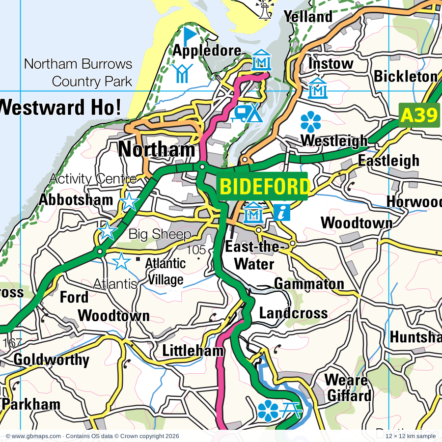
Explore the full 60 × 60 km Bideford regional road map at 1:250,000, covering Bideford, Northam, Holsworthy, Barnstaple, Stratton. Compare the complete coverage below; a detailed PDF sample is available free.
East Okement River, Little Dart River, River Bray, River Carey, River Claw, River Deer, River Mole, River Okement, River Ottery, River Tamar, River Taw, River Thrushel
More waterways
River Torridge, River Waldon, River Wolf, River Yeo, West Okement Rive, West Okement River
Landmarks & landscape
Abbotsham Activity Centre, All Terrain Quads, Arlington Court, Atlantic Outlet Shopping Centre, Atlantis Adventure Park, Bideford Railway Museum, Burton Museum and Art Gallery, Braunton Museum, Broomhill Sculpture Garden, Castle, Chambercombe Manor, Chapelgate Pottery, Chittlehampton Pottery, DARTMOOR NATIONAL PARK, EXMOOR NATIONAL PARK
More named features
Clovelly Court Gardens, Cobbaton Combat Collection, Combe Martin Museum, Combe Martin Wildlife & Dinosaur Park, Dartington Glass Factory, Dartmoor Railway, Docton Mill Gardens, Exmoor Zoo, Finch Foundry, Gnome Reserve, Halsdon Nature Reserve, Hartland Abbey and Gardens, Hartland Quay Museum, Hatherleigh Pottery, Hele Mill, Holsworthy Museum, Ilfracombe Aquarium, Ilfracombe Museum, Instow Signal Box, Killarney Springs Family Leisure Park, Lundy Marine National Nature Reserve, Lynton and Barnstaple Railway, Marsh Farm Attraction, Marwood Hill Gardens, Mortehoe Cart Linhay, Museum of Barnstaple & North Devon, Barnstaple Heritage Centre, Museum of Dartmoor Life, North Devon Maritime Museum, North Devon Quads, Northam Burrows Country Park, Okehampton Castle, Penhallam Manor House (remains of), Rosemoor Garden, Tapeley Park Gardens, The Big Sheep Family Entertainment Park, The Castle Heritage Centre, The Clovelly Centre, The Downes House, The Milky Way Adventure Park, Torrington 1646, Tunnels Beaches, Ilfracombe Arts And Crafts Gallery, Verity statue, Upper Tamar Lake Visitor Centre, Watermouth Castle, Watermouth Castle Theme Park, Witchcraft Museum & Visitor Centre
Wholly or partly within the full map rectangle. These boundaries are coverage information, not additional artwork layers.
CornwallPartly within
Mid Devon DistrictPartly within
North Devon DistrictPartly within
Torridge DistrictPartly within
West Devon DistrictPartly within
Wards & electoral divisions 56 areas
Appledore Ward
Barnstaple Central Ward
Barnstaple with Pilton Ward
Barnstaple with Westacott Ward
Bickington Ward
Bideford East Ward
Bideford North Ward
Bideford South Ward
Bideford West Ward
Bishop's Nympton Ward (part)
Bratton Fleming Ward (part)
Braunton East Ward
Braunton West & Georgeham Ward
Bridestowe Ward (part)
Broadheath Ward (part)
Chagford Ward (part)
Chittlehampton Ward (part)
Chulmleigh Ward (part)
Combe Martin Ward
Dartmoor Ward (part)
Drewsteignton Ward (part)
Exbourne Ward (part)
Fremington Ward
Great Torrington Ward
Hartland Ward
Hatherleigh Ward
Heanton Punchardon Ward
Holsworthy Ward
Ilfracombe East Ward
Ilfracombe West Ward
Instow Ward
Landkey Ward
Lynton & Lynmouth Ward (part)
Marwood Ward
Milton & Tamarside Ward
Monkleigh & Putford Ward
Mortehoe Ward
Newport Ward
North Molton Ward (part)
Northam Ward
Okehampton North Ward
Okehampton South Ward (part)
Roundswell Ward
Shebbear & Langtree Ward
South Molton Ward (part)
South Tawton Ward (part)
Taw Vale Ward (part)
Two Rivers & Three Moors Ward
Upper Yeo & Taw Ward (part)
Westward Ho! Ward
Winkleigh Ward
Bude ED
Camelford & Boscastle ED (part)
Launceston North & North Petherwin ED (part)
Poundstock ED
Stratton, Kilkhampton & Morwenstow ED
Civil parishes & communities 166 areas
Abbots Bickington CP
Abbotsham CP
Alverdiscott CP
Alwington CP
Arlington CP
Ashford CP
Ashreigney CP
Ashwater CP
Atherington CP
Barnstaple CP
Beaford CP
Beaworthy CP
Belstone CP
Berrynarbor CP
Bideford CP
Bishop's Tawton CP
Bittadon CP
Black Torrington CP
Bondleigh CP
Boyton CP
Bradford CP
Bradworthy CP
Bratton Clovelly CP (part)
Bratton Fleming CP
Braunton CP
Brayford CP (part)
Bridestowe CP (part)
Bridgerule CP
Broadwoodkelly CP
Broadwoodwidger CP (part)
Brushford CP
Buckland Brewer CP
Buckland Filleigh CP
Bude-Stratton CP
Bulkworthy CP
Burrington CP
Chagford CP (part)
Challacombe CP (part)
Chawleigh CP (part)
Chittlehamholt CP
Chittlehampton CP
Chulmleigh CP (part)
Clawton CP
Clovelly CP
Coldridge CP (part)
Combe Martin CP
Cookbury CP
Dartmoor Forest CP (part)
Dolton CP
Dowland CP
Drewsteignton CP (part)
East Down CP
East Putford CP
East and West Buckland CP
Eggesford CP
Exbourne CP
Filleigh CP (part)
Forrabury and Minster CP (part)
Fremington CP
Frithelstock CP
George Nympton CP (part)
Georgeham CP
Germansweek CP
Goodleigh CP
Great Torrington CP
Halwill CP
Hartland CP
Hatherleigh CP
Heanton Punchardon CP
High Bickington CP
Highampton CP
Hollacombe CP
Holsworthy CP
Holsworthy Hamlets CP
Horwood, Lovacott and Newton Tracey CP
Huish CP
Huntshaw CP
Iddesleigh CP
Ilfracombe CP
Instow CP
Inwardleigh CP
Jacobstow CP
Jacobstowe CP
Kentisbury CP
Kilkhampton CP
King's Nympton CP (part)
LCPs of Bridestowe and Sourton (part)
Landcross CP
Landkey CP
Langtree CP
Launcells CP
Lesnewth CP (part)
Little Torrington CP
Littleham CP
Loxhore CP
Luffincott CP
Lynton and Lynmouth CP (part)
Marhamchurch CP
Martinhoe CP
Marwood CP
Meeth CP
Merton CP
Milton Damerel CP
Monkleigh CP
Monkokehampton CP
Mortehoe CP
Morwenstow CP
Newton St. Petrock CP
North Molton CP (part)
North Petherwin CP (part)
North Tamerton CP
North Tawton CP (part)
Northam CP
Northcott CP
Northlew CP
Okehampton CP
Okehampton Hamlets CP (part)
Otterham CP (part)
Pancrasweek CP
Parkham CP
Parracombe CP (part)
Peters Marland CP
Petrockstow CP
Pilton West CP
Poundstock CP
Pyworthy CP
Roborough CP
Sampford Courtenay CP
Satterleigh and Warkleigh CP
Shebbear CP
Sheepwash CP
Shirwell CP
Sourton CP (part)
South Molton CP (part)
South Tawton CP (part)
Spreyton CP (part)
St. Gennys CP
St. Giles in the Wood CP
St. Giles on the Heath CP (part)
St. Juliot CP (part)
Sticklepath CP
Stoke Rivers CP
Sutcombe CP
Swimbridge CP
Tawstock CP
Tetcott CP
Thornbury CP
Throwleigh CP (part)
Thrushelton CP (part)
Tremaine CP (part)
Trentishoe CP
Virginstow CP
Warbstow CP (part)
Weare Giffard CP
Week St. Mary CP
Welcombe CP
Wembworthy CP
Werrington CP (part)
West Down CP
West Putford CP
Westleigh CP
Whitstone CP
Winkleigh CP
Woolfardisworthy CP
Yarnscombe CP
Zeal Monachorum CP (part)
Source: the GBMaps road atlas, OS Boundary-Line and postcode mapping datasets. Source editions are being checked for publication. Unmarked boundary names are wholly within the sheet; “part” means the map edge crosses the area.
INSIDE YOUR DOWNLOAD
A proper road map, in useful formats
Road classifications, towns and villages, railways, rivers, landscape detail and tourist symbols, brought together in the GBMaps regional road atlas style.
PDF for the finished map. SVG and layered Illustrator artwork for adapting colours, adding your own information and preparing designs.
THE FINISHED SHEET
Designed for print and presentation
Map coverage
60 × 60 km
Sample coverage
12 × 12 km
Print layout
A3 landscape · enlarged 1:250k cartography
Sheet furniture
Border, scale bar, key & north arrow
A few useful details
What changes when I select another square?
Select a surrounding square to bring it into the centre and reveal the maps around it. Each square is a different 60 × 60 km map. The preview, free sample and selected download change together. Neighbouring sheets overlap by 30 km so you can choose the coverage that suits you.
Is the free sample a vector map?
The on-page detail is an SVG. The free download is a separate 12 × 12 km PDF with a link to the full map. Please retain its copyright credits and product link when sharing it.
Can I buy a larger combined map?
These downloads are individual ready-made sheets. Contact GBMaps if you need a larger combined area.