Bath regional road map. Full 60 × 60 km PDF, SVG and Illustrator files, with a free PDF sample.

GBMAPS.COM

Bath Regional Road Map

Call Us Now for Help01751 473136

GREAT BRITAIN ROAD ATLAS · 1:250,000 GB-390-0150

Bath & surrounding area

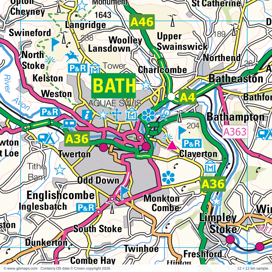
Explore the full 60 × 60 km Bath regional road map at 1:250,000, covering Westbury, Warminster, Trowbridge, Frome, Melksham. Compare the complete coverage below; a detailed PDF sample is available free.

BATH & SURROUNDING AREAREGIONAL ROAD MAP
60 × 60 km · Full map previewDownload the free SVG ↓

INSIDE THE FULL 60 × 60 KM MAP

Explore the Bath map area

1:250,000 cartography

Towns, villages & places

More mapped places (305)
  • Edington
  • Heywood
  • Hawkeridge
  • Yarnbrook
  • Bishopstrow
  • Coulston
  • Norton Bavant
  • Rudge
  • Erlestoke
  • Chapmanslade
  • Corsley
  • Heytesbury
  • Southwick
  • Keevil
  • Crockerton
  • Knook
  • Tytherington
  • Berkley
  • Bulkington
  • Marston
  • Corton
  • Beckington
  • Rode
  • Worton
  • Semington
  • Wingfield
  • Chitterne
  • Oldford
  • Tellisford
  • Woolverton
  • Lullington
  • Boyton
  • Staverton
  • Berryfield
  • Bowerhill
  • Poulshot
  • Seend
  • Horningsham
  • Sherrington
  • Laverton
  • Holt
  • Potterne
  • Westwood
  • Sells Green
  • Easterton
  • Eastcott
  • Tilshead
  • Tytherington
  • Stockton
  • Winsley
  • Bapton
  • Rowde
  • Freshford
  • Chicklade
  • Shaw
  • Urchfont
  • Deptford
  • Hardington
  • Stert
  • Atworth
  • Trudoxhill
  • Beanacre
  • Bromham
  • Whitley
  • Whatley
  • Wylye
  • Orcheston
  • Faulkland
  • Nunney
  • Hindon
  • Hemington
  • Roundway
  • Mells
  • Chittoe
  • Wedhampton
  • Claverton
  • Twinhoe
  • Shrewton
  • Etchilhampton
  • Wellow
  • Lacock
  • Coate
  • Gastard
  • Chilmark
  • Chantry
  • South Stoke
  • Ridge
  • Kilmington
  • Neston
  • Chirton
  • Heddington
  • Patney
  • Notton
  • Combe Hay
  • Vobster
  • Shoscombe
  • Stourton
  • Box
  • Horton
  • Bathford
  • Bathampton
  • Stockley
  • Ashley
  • Marden
  • Leighton
  • Box Hill
  • Wanstrow
  • Easton
  • Kilmersdon
  • Rudloe
  • Beechingstoke
  • All Cannings
  • Newtown
  • Ditteridge
  • Batheaston
  • Stapleford
  • Dunkerton
  • Tisbury
  • Downhead
  • Coleford
  • Derry Hill
  • Wilsford
  • Allington
  • Blackland
  • Dinton
  • Zeals
  • Charlton
  • Carlingcott
  • Huntingford
  • North Brewham
  • Chicksgrove
  • Englishcombe
  • Baverstock
  • Sedgehill
  • Studley
  • Colerne
  • Inglesbatch
  • Holcombe
  • Bourton
  • Charlcombe
  • Semley
  • Woodborough
  • Priston
  • Rushall
  • Camerton
  • Stoford
  • Compton
  • Penselwood
  • Dean
  • Fovant
  • St Catherine
  • Batcombe
  • Hardway
  • Swallowcliffe
  • Alton Barnes
  • Thickwood
  • Biddestone
  • Silton
  • Woolley
  • Ansty
  • Enford
  • Upavon
  • Cranmore
  • Longstreet
  • Cherhill
  • Alton Priors
  • Bremhill
  • Westcombe
  • Slaughterford
  • Waterlip
  • Fittleton
  • Timsbury
  • Netheravon
  • Motcombe
  • Langridge
  • Nettlebridge
  • Chesterblade
  • Chilcompton
  • Figheldean
  • Wilsford
  • Ford
  • Lansdown
  • Corston
  • Burcombe
  • Lake
  • East Tytherton
  • Paulton
  • Redlynch
  • Doulting
  • Farmborough
  • Durrington
  • Kelston
  • Marksbury
  • Wilcot
  • Oakhill
  • Milston
  • Marshfield
  • Cucklington
  • Ashwick
  • Beckhampton
  • West End
  • Hallatrow
  • Yatesbury
  • Ludwell
  • Fifield Bavant
  • Spirthill
  • Evercreech
  • Bulford
  • Alvediston
  • Saltford
  • Hilmarton
  • Huish
  • Foxham
  • Burnett
  • Hunstrete
  • Prestleigh
  • Lamyatt
  • Pewsey
  • Quidhampton
  • Charlton
  • Highway
  • Avebury
  • Swineford
  • Oare
  • Binegar
  • Emborough
  • Netherhampton
  • West Kington
  • Cann
  • Nettleton
  • Mead End
  • Clutton
  • Chelwood
  • Bowerchalke
  • Bitton
  • Clevancy
  • Goatacre
  • Woodminton
  • Doynton
  • Bishopstone
  • Stour Row
  • Wick
  • Dyrham
  • Grittleton
  • Lockeridge
  • Burton
  • Ditcheat
  • Fyfield
  • Ford
  • Bradenstoke
  • Preston
  • Alhampton
  • Pensford
  • Lyneham
  • Bridgeyate
  • Holton
  • Tormarton
  • Pylle
  • Abson
  • Hinton
  • Porton
  • Belluton
  • North Cheriton
  • Yarlington
  • Gomeldon
  • Sutton
  • Idmiston
  • Bushton
  • Tockenham
  • Wraxall
  • Manton
  • Horsington
  • Homington
  • Siston
  • Pucklechurch
  • Galhampton
  • Templecombe
  • Codrington
  • Whitchurch
  • Broad Hinton
  • Blackford
  • Broad Town
  • Britford
  • Yenston
  • Odstock
  • Rockley
  • Alford
  • Wapley
  • Nunton
  • Stowell
  • Uffcott
  • Bodenham
  • Westerleigh
  • South Cadbury
  • Mangotsfield
  • Alderbury
  • Sutton Montis
  • Sparkford
  • Whaddon
  • Stapleton
  • Hambrook
  • Poyntington
  • Downton
  • Rimpton
  • Chiseldon

Roads across this sheet

M4, M32, A4, A30, A36, A37, A38, A39, A46, A320, A338, A342, A345, A346, A350, A354, A357, A359, A360, A361, A362, A363, A365, A366

More road numbers

A367, A368, A371, A420, A429, A431, A432, A3028, A3039, A3062, A3094, A3098, A3102, A3604, A4017, A4032, A4174, A4175, A4320, A4361, B390, B3019, B3052, B3080, B3081, B3083, B3085, B3086, B3087, B3089, B3090, B3091, B3092, B3095, B3097, B3098, B3099, B3101, B3105, B3106, B3107, B3108, B3109, B3110, B3111, B3114, B3115, B3116, B3118, B3119, B3122, B3130, B3135, B3136, B3139, B3145, B3148, B3152, B3153, B3353, B3355, B3356, B3414, B4003, B4005, B4039, B4046, B4048, B4051, B4056, B4058, B4069, B4122, B4158, B4427, B4465, B4467, B4469, B4528, B4643

Rivers & waterways

Floating Harbour, Kennet & Avon Canal, River Avon, River Bourne, River Brue, River Cale, River Cary, River Ebble, River Frome, River Kennet, River Nadder, River Stour

More waterways

River Wylye, The Feeder, Whitelake

Landmarks & landscape

Alexander Keiller Museum, Great Barn, Alfred's Tower, Alton Barnes White Horse, Alton Barnes White Horse (Hill Figure), American Museum in Britain, Assembly Rooms, Royal Crescent, The Circus, Thermae Bath Spa, Atwell-Wilson Motor Museum, Avebury (World Heritage Site), Avebury Manor and Garden, Avebury Stone Circle, Avon Valley Country Park, Avon Valley Railway, NEW FOREST NATIONAL PARK

More named features

Avon Valley Wildlife Park, Barbury Castle Country Park, Barbury Castle Racecourse, Barton Farm Country Park, Bath Abbey, Bath Racecourse, Beckford's Tower, Bliss Meadows, Bowood House, Bowood House & Gardens, Bradford on Avon Museum, Bradford-on-Avon Tithe Barn, Bratton Camp, Westbury White Horse, Bristol Blue Glass, Broad Town White Horse (Hill Figure), Broadleas Gardens, Brokerswood Country Park, Bruton Museum, Bulford Kiwi, Bulford Kiwi (Hill Figure), Bush Farm Bison Centre, Cadbury Castle, Caen Hill Locks, Canal Visitor Centre, Castle Cary Museum, Castle Combe Motor Racing Circuit, Castle Combe Museum, Cherhill White Horse, Cherhill White Horse (Hill Figure), Chippenham Museum & Heritage Centre, Wiltshire and Swindon History Centre, City Museum & Art Gallery, M Shed Museum, Georgian House, Harvey's Wine Museum, City of Bath (World Heritage Site), Clanger and Picket Wood Nature Reserve, Compton Chamberlain Military Badge, Corsham Court, Corsham Court and Gardens, Corsham Gardens, Devizes Castle, Devizes Millennium White Horse (Hill Figure), Devizes Museum, Kennet & Avon Canal Trust Centre, Wadworth Brewery, Devizes White Horse, Downton Moot, Dyrham Park, East Somerset Railway, Edington Priory, Farleigh Castle, Farleigh Hungerford Castle, Farmer Giles' Farmstead, Folly Farm Nature Reserve, Fovant Down Military Badges, Fovant Down Regimental Badges (Hill Figure), Fox Talbot Museum, Frome Museum, Fyfield Down National Nature Reserve, Gants Mill and Garden, Georgian Garden, Gillingham Museum, Great Chalfield Manor, Green Lane Wood Nature Reserve, Smiths Well Wood Nature Reserve, Hackpen White Horse (Hill Figure), Hatfield Earthworks, Hauser & Wirth Somerset, Haynes Motor Museum, Heale House Garden, Hinton Priory, Holburne Museum & Crafts Study Centre, Bath Postal Museum, William Herschel Museum, Building of Bath Museum, The Jane Austin Centre, Science Museum, Horseworld, Jone's Mill Nature Reserve, Kennet and Avon Canal Trust Centre, Kingsettle Wood, Lacock Abbey, Lamb Down Military Badge, Lamb Down Military Badge (Hill Figure), Larkhill Point to Point Racecourse, Little Clarendon, Longleat House, Longleat House & Attractions, Longleat Safari Park, Maize Maze, Market Lavington Museum, Marlborough White Horse, Marlborough White Horse (Hill Figure), Mere Museum, Mompesson House, Morgans Hill Nature Reserve, Museum of Bath at Work, No 1 Royal Crescent, Sally Lunn's Kitchen Museum, Museum of Costume, The Roman Baths, Museum of East Asian Art, Netheravon Dovecote, Nunney Castle, Old Sarum, Old Wardour Castle, Oldbury Court Estate, Parsonage Down Nature Reserve, Pewsey Downs, Pewsey Heritage Centre, Pewsey White Horse, Pewsey White Horse (Hill Figure), Philipps House, Philipps House & Dinton Park, Prior Park Landscape Garden, Pythouse Walled Garden, Radstock & District Museum, Redcoats Regimental Museum, Salisbury and South Wilts Museum, The John Creasey Museum, Secrets of Salisbury Medieval Hall, Roundway Hill Covert, Royal Bath and West of England Showground, Salisbury Arts Centre, Salisbury Cathedral, Salisbury Racecourse, Sandford Orcas Manor House, Science Museum Wroughton, Shaftesbury Town Museum, Shaftesbury Abbey Museum and Gardens, Shear Water, Sheldon Manor Gardens, Silbury Hill, Silbury Hill, West Kennett Long Barrow, Sir Bevil Grenville's Monument, Solar Farm, Somerset and Dorset Heritage Railway, Southwick Country Park, St Laurence Church, Stanton Drew Stone Circles, Stonehenge, Stonehenge (World Heritage Site), Stonehenge Visitor Centre, Stoney Littleton Long Barrow, Stourhead Gardens, Stourhead House, Stourton House Flower Gardens, Sutton Down Military Badges, The Bath Aqua Theatre of Glass, The Courts Garden, The Dewey Museum, The Merchant's House, The Old Potato Yard, The Peto Garden, The Sanctuary, Tithe Barn, Trowbridge Museum, Visitor Centre, West Kennett Avenue, West Kennett Long Barrow, Westbury Solar Farm, Westbury White Horse (Hill Figure), Westwood Manor, Whistley Farm Solar Farm, White Sheet Hill Nature Reserve, Willsbridge Mill, Wilton Carpet Factory, Wilton House & Gardens, Wincanton Racecourse, Windmill Hill, Windmill Hill Camp, Windsor Farm Solar Farm, Woodhenge, Wylye Valley Vineyard
Local authority & parish coverage

Wholly or partly within the full map rectangle. These boundaries are coverage information, not additional artwork layers.

  • Bath and North East SomersetPartly within
  • City of BristolPartly within
  • DorsetPartly within
  • New Forest DistrictPartly within
  • SomersetPartly within
  • South GloucestershirePartly within
  • SwindonPartly within
  • WiltshirePartly within
Wards & electoral divisions 177 areas
  • Ashley Ward (part)
  • Bathavon North Ward
  • Bathavon South Ward
  • Bathwick Ward
  • Beacon Ward (part)
  • Bishopston & Ashley Down Ward (part)
  • Bitton & Oldland Common Ward
  • Boyd Valley Ward (part)
  • Brislington East Ward
  • Brislington West Ward
  • Chew Valley Ward (part)
  • Chipping Sodbury & Cotswold Edge Ward (part)
  • Chiseldon & Ridgeway Ward (part)
  • Clutton & Farmborough Ward
  • Combe Down Ward
  • Cranborne Chase Ward (part)
  • Downlands & Forest North Ward (part)
  • Easton Ward
  • Eastville Ward
  • Emersons Green Ward
  • Filton Ward (part)
  • Filwood Ward (part)
  • Frampton Cotterell Ward (part)
  • Frenchay & Downend Ward
  • Frome Vale Ward
  • Gillingham Ward
  • Hanham Ward
  • Hengrove & Whitchurch Park Ward (part)
  • High Littleton Ward
  • Hillfields Ward
  • Horfield Ward (part)
  • Keynsham East Ward
  • Keynsham North Ward
  • Keynsham South Ward
  • Kingsmead Ward
  • Kingswood Ward
  • Knowle Ward (part)
  • Lambridge Ward
  • Lansdown Ward
  • Lawrence Hill Ward (part)
  • Lockleaze Ward (part)
  • Longwell Green Ward
  • Mendip Ward (part)
  • Midsomer Norton North Ward
  • Midsomer Norton Redfield Ward
  • Moorlands Ward
  • New Cheltenham Ward
  • Newbridge Ward
  • Odd Down Ward
  • Oldfield Park Ward
  • Parkwall & Warmley Ward
  • Paulton Ward
  • Peasedown Ward
  • Publow & Whitchurch Ward (part)
  • Radstock Ward
  • Saltford Ward
  • Shaftesbury Town Ward
  • Sherborne Rural Ward (part)
  • Southdown Ward
  • St. George Central Ward
  • St. George Troopers Hill Ward
  • St. George West Ward
  • Stalbridge & Marnhull Ward (part)
  • Staple Hill & Mangotsfield Ward
  • Stockwood Ward
  • Stoke Gifford Ward (part)
  • Stoke Park & Cheswick Ward
  • Timsbury Ward
  • Twerton & Whiteway Ward
  • Walcot Ward
  • Westfield Ward
  • Westmoreland Ward
  • Weston Ward
  • Widcombe & Lyncombe Ward
  • Windmill Hill Ward (part)
  • Winterbourne Ward (part)
  • Woodstock Ward
  • Wroughton & Wichelstowe Ward (part)
  • Aldbourne & Ramsbury ED (part)
  • Alderbury & Whiteparish ED (part)
  • Amesbury East & Bulford ED (part)
  • Amesbury South ED
  • Amesbury West ED
  • Avon Valley ED (part)
  • Blackmoor Vale ED (part)
  • Bowerhill ED
  • Box & Colerne ED
  • Bradford-on-Avon North ED
  • Bradford-on-Avon South ED
  • Brinkworth ED (part)
  • Bromham, Rowde & Roundway ED
  • By Brook ED (part)
  • Calne Central ED
  • Calne Chilvester & Abberd ED
  • Calne North ED
  • Calne Rural ED
  • Calne South ED
  • Castle Cary ED (part)
  • Chippenham Cepen Park & Derriads ED
  • Chippenham Cepen Park & Hunters Moon ED
  • Chippenham Hardenhuish ED
  • Chippenham Hardens & Central ED
  • Chippenham Lowden & Rowden ED
  • Chippenham Monkton ED
  • Chippenham Pewsham ED
  • Chippenham Sheldon ED
  • Corsham Ladbrook ED
  • Corsham Pickwick ED
  • Corsham Without ED
  • Devizes East ED
  • Devizes North ED
  • Devizes Rural West ED
  • Devizes South ED
  • Downton & Ebble Valley ED (part)
  • Durrington ED
  • Ethandune ED
  • Fovant & Chalke Valley ED (part)
  • Frome East ED
  • Frome North ED
  • Frome West ED
  • Hilperton ED
  • Holt ED
  • Kington ED (part)
  • Laverstock ED
  • Ludgershall North & Rural ED (part)
  • Lyneham ED (part)
  • Marlborough East ED (part)
  • Marlborough West ED
  • Melksham East ED
  • Melksham Forest ED
  • Melksham South ED
  • Melksham Without North & Shurnhold ED
  • Melksham Without West & Rural ED
  • Mendip Central and East ED
  • Mendip Hills ED (part)
  • Mendip South ED (part)
  • Mere ED
  • Nadder Valley ED
  • Old Sarum & Lower Bourne Valley ED (part)
  • Pewsey ED (part)
  • Pewsey Vale West ED
  • Redlynch & Landford ED (part)
  • Royal Wootton Bassett East ED (part)
  • Royal Wootton Bassett South & West ED (part)
  • Salisbury Bemerton Heath ED
  • Salisbury Fisherton & Bemerton Village ED
  • Salisbury Harnham East ED
  • Salisbury Harnham West ED
  • Salisbury Milford ED
  • Salisbury St. Edmund's ED
  • Salisbury St. Francis & Stratford ED
  • Salisbury St. Paul's ED
  • Shepton Mallet ED (part)
  • Southwick ED
  • The Lavingtons ED
  • Till Valley ED
  • Tisbury ED (part)
  • Trowbridge Adcroft ED
  • Trowbridge Central ED
  • Trowbridge Drynham ED
  • Trowbridge Grove ED
  • Trowbridge Lambrok ED
  • Trowbridge Park ED
  • Trowbridge Paxcroft ED
  • Urchfont & Bishops Cannings ED
  • Warminster Broadway ED
  • Warminster East ED
  • Warminster North & Rural ED
  • Warminster West ED
  • Westbury East ED
  • Westbury North ED
  • Westbury West ED
  • Wilton ED
  • Wincanton & Bruton ED
  • Winsley & Westwood ED
  • Winterslow & Upper Bourne Valley ED (part)
  • Wylye Valley ED
Civil parishes & communities 383 areas
  • Abbas and Templecombe CP
  • Acton Turville CP (part)
  • Aldbourne CP (part)
  • Alderbury CP (part)
  • Alford CP (part)
  • All Cannings CP
  • Allington CP (part)
  • Alton CP
  • Alvediston CP
  • Amesbury CP (part)
  • Ansford CP
  • Ansty CP
  • Ashwick CP
  • Atworth CP
  • Avebury CP
  • Barford St. Martin CP
  • Batcombe CP
  • Bathampton CP
  • Batheaston CP
  • Bathford CP
  • Beckington CP
  • Beechingstoke CP
  • Berkley CP
  • Berwick Bassett CP
  • Berwick St. James CP
  • Berwick St. John CP (part)
  • Berwick St. Leonard CP
  • Biddestone & Slaughterford CP
  • Binegar CP
  • Bishops Cannings CP
  • Bishopstone CP
  • Bishopstrow CP
  • Bitton CP
  • Bourton CP
  • Bowerchalke CP (part)
  • Box CP
  • Boyton CP
  • Bradford-on-Avon CP
  • Bratton CP
  • Bratton Seymour CP
  • Breamore CP (part)
  • Bremhill CP
  • Brewham CP
  • Britford CP
  • Brixton Deverill CP
  • Broad Chalke CP
  • Broad Hinton CP
  • Broad Town CP (part)
  • Bromham CP
  • Broughton Gifford CP
  • Bruton CP
  • Buckhorn Weston CP
  • Buckland Dinham CP
  • Bulford CP (part)
  • Bulkington CP
  • Burcombe Without CP
  • Calne CP
  • Camerton CP
  • Cann CP (part)
  • Castle Cary CP
  • Castle Combe CP
  • Chapmanslade CP
  • Charlcombe CP
  • Charlton Horethorne CP
  • Charlton Musgrove CP
  • Charlton St. Peter CP
  • Chelwood CP
  • Cherhill CP
  • Cheverell Magna CP
  • Chew Magna CP (part)
  • Chewton Mendip CP (part)
  • Chicklade CP
  • Chilcompton CP
  • Chilmark CP
  • Chippenham CP
  • Chippenham Without CP
  • Chirton CP
  • Chiseldon CP (part)
  • Chitterne CP
  • Christian Malford CP (part)
  • Clarendon Park CP (part)
  • Claverton CP
  • Clutton CP
  • Clyffe Pypard CP
  • Codford CP
  • Cold Ashton CP
  • Coleford CP
  • Colerne CP
  • Combe Hay CP
  • Compton Abbas CP (part)
  • Compton Bassett CP
  • Compton Chamberlayne CP
  • Compton Dando CP
  • Compton Pauncefoot CP
  • Coombe Bissett CP
  • Corsham CP
  • Corsley CP
  • Corston CP
  • Corton Denham CP
  • Coulston CP
  • Cranmore CP
  • Croscombe CP (part)
  • Cucklington CP
  • Dauntsey CP (part)
  • Derry Hill & Studley CP
  • Devizes CP
  • Dilton Marsh CP
  • Dinton CP
  • Ditcheat CP (part)
  • Dodington CP (part)
  • Donhead St. Andrew CP
  • Donhead St. Mary CP (part)
  • Doulting CP
  • Downend and Bromley Heath CP
  • Downhead CP
  • Downton CP (part)
  • Doynton CP
  • Dunkerton and Tunley CP
  • Durnford CP
  • Durrington CP
  • Dyrham and Hinton CP
  • East Kennett CP
  • East Knoyle CP
  • East Pennard CP (part)
  • East Stour CP
  • Easterton CP
  • Easton CP (part)
  • Ebbesborne Wake CP (part)
  • Edington CP
  • Emborough CP (part)
  • Emersons Green CP
  • Enford CP
  • Englishcombe CP
  • Erlestoke CP
  • Etchilhampton CP
  • Evercreech CP
  • Everleigh CP (part)
  • Farmborough CP
  • Farrington Gurney CP
  • Fifehead Magdalen CP (part)
  • Figheldean CP (part)
  • Filton CP (part)
  • Firsdown CP (part)
  • Fittleton cum Haxton CP (part)
  • Fonthill Bishop CP
  • Fonthill Gifford CP
  • Fontmell Magna CP (part)
  • Fovant CP
  • Freshford CP
  • Frome CP
  • Fyfield CP
  • Gillingham CP
  • Great Elm CP
  • Great Hinton CP
  • Great Wishford CP
  • Grittleton CP (part)
  • Hanham Abbots CP
  • Hanham CP
  • Heddington CP
  • Hemington CP
  • Henstridge CP (part)
  • Heytesbury CP
  • Heywood CP
  • High Littleton CP
  • Hilmarton CP
  • Hilperton CP
  • Hindon CP
  • Hinton Blewett CP (part)
  • Hinton Charterhouse CP
  • Holcombe CP
  • Holt CP
  • Holton CP
  • Horningsham CP
  • Horsington CP
  • Idmiston CP (part)
  • Keevil CP
  • Kelston CP
  • Keynsham CP
  • Kilmersdon CP
  • Kilmington CP
  • Kingston Deverill CP
  • Kingswood CP
  • Kington Langley CP
  • Kington Magna CP
  • Kington St. Michael CP
  • Knook CP
  • Lacock CP
  • Lamyatt CP
  • Langley Burrell Without CP
  • Laverstock CP
  • Leigh-on-Mendip CP
  • Limpley Stoke CP
  • Little Cheverell CP
  • Litton CP (part)
  • Longbridge Deverill CP
  • Lovington CP (part)
  • Lullington CP
  • Lydiard Tregoze CP (part)
  • Lyneham and Bradenstoke CP (part)
  • Maiden Bradley with Yarnfield CP
  • Manningford CP
  • Maperton CP
  • Marden CP
  • Margaret Marsh CP (part)
  • Market Lavington CP
  • Marksbury CP
  • Marlborough CP (part)
  • Marnhull CP (part)
  • Marshfield CP
  • Marston CP
  • Marston Magna CP (part)
  • Martin CP (part)
  • Melbury Abbas CP (part)
  • Melksham CP
  • Melksham Without CP
  • Mells CP
  • Mere CP
  • Midsomer Norton CP
  • Milborne Port CP (part)
  • Mildenhall CP (part)
  • Milston CP (part)
  • Milton Clevedon CP
  • Milton Lilbourne CP (part)
  • Monkton Combe CP
  • Monkton Farleigh CP
  • Motcombe CP
  • Netheravon CP
  • Netherhampton CP
  • Nettleton CP (part)
  • Newton St. Loe CP
  • North Barrow CP (part)
  • North Bradley CP
  • North Cadbury CP
  • North Cheriton CP
  • North Newnton CP
  • North Stoke CP
  • North Wraxall CP
  • Norton Bavant CP
  • Norton Malreward CP (part)
  • Norton St. Philip CP
  • Nunney CP
  • Odstock CP
  • Ogbourne St. Andrew CP (part)
  • Ogbourne St. George CP (part)
  • Oldland CP
  • Orcheston CP
  • Patney CP
  • Paulton CP
  • Peasedown St. John CP
  • Pen Selwood CP
  • Pewsey CP
  • Pilton CP (part)
  • Pitcombe CP
  • Pitton and Farley CP (part)
  • Potterne CP
  • Poulshot CP
  • Poyntington CP (part)
  • Preshute CP
  • Priston CP
  • Publow CP
  • Pucklechurch CP
  • Pylle CP (part)
  • Queen Camel CP (part)
  • Quidhampton CP
  • Radstock CP
  • Redlynch CP (part)
  • Rimpton CP (part)
  • Rockbourne CP (part)
  • Rode CP
  • Rowde CP
  • Royal Wootton Bassett CP (part)
  • Rushall CP
  • Salisbury CP
  • Saltford CP
  • Sandford Orcas CP (part)
  • Savernake CP (part)
  • Seagry CP (part)
  • Sedgehill and Semley CP
  • Seend CP
  • Selwood CP
  • Semington CP
  • Shaftesbury CP
  • Shepton Mallet CP (part)
  • Shepton Montague CP
  • Sherrington CP
  • Shoscombe CP
  • Shrewton CP
  • Silton CP
  • Siston CP
  • Sixpenny Handley and Pentridge CP (part)
  • South Barrow CP (part)
  • South Cadbury and Sutton Montis CP
  • South Newton CP
  • South Wraxall CP
  • Southstoke CP
  • Southwick CP
  • Sparkford CP (part)
  • St. Catherine CP
  • St. Cuthbert Out CP (part)
  • Stalbridge CP (part)
  • Stanton Drew CP (part)
  • Stanton St. Bernard CP
  • Stanton St. Quintin CP (part)
  • Staple Hill and Mangotsfield CP
  • Stapleford CP
  • Staverton CP
  • Steeple Ashton CP
  • Steeple Langford CP
  • Stert CP
  • Stockton CP
  • Stoke Gifford CP (part)
  • Stoke Park and Cheswick CP
  • Stoke St. Michael CP
  • Stoke Trister CP
  • Ston Easton CP
  • Stour Provost CP (part)
  • Stourton with Gasper CP
  • Stowey-Sutton CP (part)
  • Stratford Toney CP
  • Stratton on the Fosse CP
  • Sutton Benger CP
  • Sutton Mandeville CP
  • Sutton Veny CP
  • Swainswick CP
  • Swallowcliffe CP
  • Teffont CP
  • Tellisford CP
  • Temple Cloud with Cameley CP (part)
  • Tilshead CP
  • Timsbury CP
  • Tisbury CP
  • Tockenham CP (part)
  • Todber CP (part)
  • Tollard Royal CP (part)
  • Tormarton CP (part)
  • Trent CP (part)
  • Trowbridge CP
  • Trudoxhill CP
  • Upavon CP
  • Upton Lovell CP
  • Upton Noble CP
  • Upton Scudamore CP
  • Urchfont CP
  • Wanstrow CP
  • Warminster CP
  • Wellow CP
  • West Ashton CP
  • West Bradley CP (part)
  • West Knoyle CP
  • West Lavington CP
  • West Overton CP
  • West Stour CP
  • West Tisbury CP
  • Westbury CP
  • Westerleigh and Coalpit Heath CP (part)
  • Westfield CP
  • Westwood CP
  • Whatley CP
  • Whitchurch CP (part)
  • Whitsbury CP (part)
  • Wick and Abson CP
  • Wilcot, Huish and Oare CP
  • Wilsford CP
  • Wilsford cum Lake CP
  • Wilton CP
  • Wincanton CP
  • Wingfield CP
  • Winsley CP
  • Winterbourne Bassett CP
  • Winterbourne CP
  • Winterbourne CP (part)
  • Winterbourne Monkton CP
  • Winterbourne Stoke CP
  • Witham Friary CP
  • Woodborough CP
  • Woodford CP
  • Wootton Rivers CP (part)
  • Worton CP
  • Wroughton CP (part)
  • Wylye CP
  • Yarlington CP
  • Yatton Keynell CP
  • Zeals CP

Source: the GBMaps road atlas, OS Boundary-Line and postcode mapping datasets. Source editions are being checked for publication. Unmarked boundary names are wholly within the sheet; “part” means the map edge crosses the area.

Place lists are selected from the map source, not a complete gazetteer. Named features describe the cartography; visitor facilities and opening status are not verified. The free sample covers only 12 × 12 km of this larger sheet.

INSIDE YOUR DOWNLOAD

A proper road map, in useful formats

Road classifications, towns and villages, railways, rivers, landscape detail and tourist symbols, brought together in the GBMaps regional road atlas style.

PDF filePDFSVG fileSVGAdobe Illustrator AI fileAi

PDF for the finished map. SVG and layered Illustrator artwork for adapting colours, adding your own information and preparing designs.

THE FINISHED SHEET

Designed for print and presentation

Map coverage
60 × 60 km
Sample coverage
12 × 12 km
Print layout
A3 landscape · enlarged 1:250k cartography
Sheet furniture
Border, scale bar, key & north arrow

A few useful details

What changes when I select another square?

Select a surrounding square to bring it into the centre and reveal the maps around it. Each square is a different 60 × 60 km map. The preview, free sample and selected download change together. Neighbouring sheets overlap by 30 km so you can choose the coverage that suits you.

Is the free sample a vector map?

The on-page detail is an SVG. The free download is a separate 12 × 12 km PDF with a link to the full map. Please retain its copyright credits and product link when sharing it.

Can I buy a larger combined map?

These downloads are individual ready-made sheets. Contact GBMaps if you need a larger combined area.

FREE PDF SAMPLE

Your free map sample

Your free 12 × 12 km sample includes a link back to this map, so you can return for the full area whenever you need it.

Download free PDF sample ↓

Get your Bath map

Map download bundle

£24.00including VATOne payment

Pay securely

One payment. Your map stays open.

Your map download

Your map files

Preparing your download…

Checking your private download link…

Your map downloads

Already bought a map?

Find the downloads from your purchases.

Enter the email address you used at checkout. We’ll email you a private link to your available map downloads.