Bath regional road map. Full 60 × 60 km PDF, SVG and Illustrator files, with a free PDF sample.

GBMAPS.COM

Bath Regional Road Map

Call Us Now for Help01751 473136

GREAT BRITAIN ROAD ATLAS · 1:250,000 GB-390-0180

Bath & surrounding area

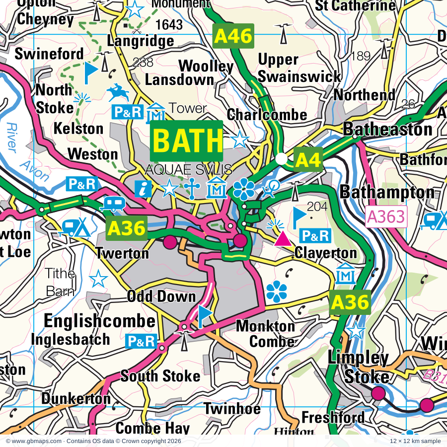
Explore the full 60 × 60 km Bath regional road map at 1:250,000, covering Chippenham, Malmesbury, Corsham, Tetbury, Calne. Compare the complete coverage below; a detailed PDF sample is available free.

BATH & SURROUNDING AREAREGIONAL ROAD MAP
60 × 60 km · Full map previewDownload the free SVG ↓

INSIDE THE FULL 60 × 60 KM MAP

Explore the Bath map area

1:250,000 cartography

Towns, villages & places

More mapped places (350)

Roads across this sheet

M4, M5, M32, A4, A36, A37, A38, A39, A46, A320, A342, A345, A346, A350, A360, A361, A362, A363, A365, A366, A367, A368, A417, A419

More road numbers

A420, A429, A431, A432, A433, A435, A3039, A3062, A3098, A3102, A3604, A4017, A4032, A4135, A4171, A4173, A4174, A4175, A4198, A4259, A4289, A4311, A4312, A4313, A4320, A4361, B3019, B3052, B3087, B3090, B3097, B3098, B3099, B3101, B3105, B3106, B3107, B3108, B3109, B3110, B3111, B3114, B3115, B3116, B3118, B3119, B3122, B3130, B3139, B3353, B3355, B3356, B4003, B4005, B4006, B4008, B4014, B4019, B4039, B4040, B4042, B4046, B4048, B4051, B4056, B4057, B4058, B4059, B4060, B4061, B4062, B4066, B4069, B4070, B4071, B4073, B4122, B4141, B4143, B4158, B4192, B4231, B4234, B4289, B4425, B4427, B4461, B4465, B4467, B4469, B4509, B4528, B4534, B4553, B4587, B4643, B4696

Rivers & waterways

Floating Harbour, Gloucester & Sharpness Canal, Kennet & Avon Canal, River Avon, River Churn, River Coln, River Frome, River Kennet, River Leach, River Ray, River Thames or Isis, Stroudwater Canal (disused)

More waterways

Thames & Severn Canal (disused), The Feeder

Landmarks & landscape

Abbey House Gardens, Alexander Keiller Museum, Great Barn, Alton Barnes White Horse, Alton Barnes White Horse (Hill Figure), American Museum in Britain, Arlington Row, Assembly Rooms, Royal Crescent, The Circus, Thermae Bath Spa, Athelstan Museum, Atwell-Wilson Motor Museum, Avebury (World Heritage Site), Avebury Manor and Garden, Avebury Stone Circle

More named features

Avon Valley Country Park, Avon Valley Railway, Avon Valley Wildlife Park, Barbury Castle Country Park, Barbury Castle Racecourse, Barton Farm Country Park, Bath Abbey, Bath Racecourse, Beckford's Tower, Berkeley Castle, Berkley Castle Gardens, Bliss Meadows, Bowood House, Bowood House & Gardens, Bradford on Avon Museum, Bradford-on-Avon Tithe Barn, Bratton Camp, Westbury White Horse, Bristol Blue Glass, Broad Town White Horse (Hill Figure), Broadleas Gardens, Brokerswood Country Park, Caen Hill Locks, Canal Visitor Centre, Castle Combe Motor Racing Circuit, Castle Combe Museum, Cattle Country Adventure Park, Charlton Park, Chavenage House, Cherhill White Horse, Cherhill White Horse (Hill Figure), Chippenham Museum & Heritage Centre, Wiltshire and Swindon History Centre, Chiseldon Museum, Cirencester Park Gardens, Cirencester Roman Amphitheatre, City Museum & Art Gallery, M Shed Museum, Georgian House, Harvey's Wine Museum, City of Bath (World Heritage Site), Clanger and Picket Wood Nature Reserve, Coate Water Country Park, Corsham Court, Corsham Court and Gardens, Corsham Gardens, Cotswold Water Park, Cotswold Water Park (Ashton Keynes Section), Cotswolds Canal Heritage Centre, Craft Centre, Cricklade Museum, Dean Forest Railway, Dean Forest Railway Museum, Dean Heritage Centre, Devizes Castle, Devizes Millennium White Horse (Hill Figure), Devizes Museum, Kennet & Avon Canal Trust Centre, Wadworth Brewery, Devizes White Horse, Dr Jenner's House, Dursley Heritage Centre, Dyrham Park, Edington Priory, Farleigh Castle, Farleigh Hungerford Castle, Folly Farm Nature Reserve, Fox Talbot Museum, Frocester Hill, Fyfield Down National Nature Reserve, Gatehouse, Georgian Garden, Go Ape Forest of Dean, Severnwye Llama Trekking, Great Chalfield Manor, Green Lane Wood Nature Reserve, Smiths Well Wood Nature Reserve, Hackpen White Horse (Hill Figure), Hatfield Earthworks, Hetty Pegler's Tump, Hinton Priory, Holburne Museum & Crafts Study Centre, Bath Postal Museum, William Herschel Museum, Building of Bath Museum, The Jane Austin Centre, Science Museum, Horseworld, Horton Court, Jack Russell Gallery, Jone's Mill Nature Reserve, Kennet and Avon Canal Trust Centre, Keynes Country Park, Kingswood Abbey Gate (ruin), Lacock Abbey, Large Solar Farm, Lydiard Park, Lydney Park House, Malmesbury Abbey, Market Lavington Museum, Marlborough White Horse, Marlborough White Horse (Hill Figure), Midger Wood Nature Reserve, Misarden Park Gardens, Morgans Hill Nature Reserve, Mouldon Hill Country Park, Museum of Bath at Work, No 1 Royal Crescent, Sally Lunn's Kitchen Museum, Museum of Costume, The Roman Baths, Museum of East Asian Art, Nagshead Nature Reserve, Nature Reserve, Neigh Bridge Country Park, Newark Park, North Meadow National Nature Reserve, Nympsfield Long Barrow, Oldbury Court Estate, Pewsey Downs, Pewsey Heritage Centre, Pewsey White Horse, Pewsey White Horse (Hill Figure), Prior Park Landscape Garden, Purton Museum, ROMAN AMPHITHEATRE, Radstock & District Museum, Ravensroost Wood Nature Reserve, Roundway Hill Covert, Science Museum Wroughton, Sheldon Manor Gardens, Silbury Hill, Silbury Hill, West Kennett Long Barrow, Sir Bevil Grenville's Monument, Solar Farm, Somerset and Dorset Heritage Railway, Source of the River Thames, Southwick Country Park, St Laurence Church, Stanton Drew Stone Circles, Stanton country Park, Stoney Littleton Long Barrow, Stroud Museum, The Museum in the Park, Swindon & Cricklade Railway, Swindon Arts Centre, Swindon Museum and Art Gallery, Richard Jefferies Museum, Steam - Museum of the Great Western Railway, Tetbury Police Museum, The Bath Aqua Theatre of Glass, The Courts Garden, The Forest of Dean Model Village, The Merchant's House, The Old Potato Yard, The Peto Garden, The Sanctuary, Thisledown, Thornbury Museum, Tithe Barn, Trowbridge Museum, Tyndale Monument, Uley Long Barrow (Hetty Pegler's Tump), West Kennett Avenue, West Kennett Long Barrow, Westbury Solar Farm, Westbury White Horse (Hill Figure), Westonbirt Arboretum, Westwood Manor, Wetmoor Nature Reserve, Wildfowl and Wetlands Trust, Willsbridge Mill, Windmill Hill, Windmill Hill Camp, Woodchester Mansion & Park, Wootton Bassett Museum, Wotton Heritage Centre, Yate Heritage Centre
Local authority & parish coverage

Wholly or partly within the full map rectangle. These boundaries are coverage information, not additional artwork layers.

  • Bath and North East SomersetPartly within
  • City of BristolPartly within
  • Cotswold DistrictPartly within
  • Forest of Dean DistrictPartly within
  • SomersetPartly within
  • South GloucestershirePartly within
  • Stroud DistrictPartly within
  • SwindonPartly within
  • West Oxfordshire DistrictPartly within
  • WiltshirePartly within
Wards & electoral divisions 235 areas
  • Abbey Ward
  • Alvescot and Filkins Ward (part)
  • Amberley and Woodchester Ward
  • Ashley Ward (part)
  • Badbury Park, Eldene & Liden Ward
  • Bathavon North Ward
  • Bathavon South Ward
  • Bathwick Ward
  • Berkeley Vale Ward
  • Bishopston & Ashley Down Ward (part)
  • Bisley Ward
  • Bitton & Oldland Common Ward
  • Blunsdon Ward
  • Boyd Valley Ward
  • Bradley Stoke North Ward
  • Bradley Stoke South Ward
  • Bream Ward (part)
  • Brislington East Ward
  • Brislington West Ward
  • Broadgreen Ward
  • Cainscross Ward
  • Cam East Ward
  • Cam West Ward
  • Chalford Ward
  • Charfield Ward
  • Charlton & Cribbs Ward (part)
  • Chedworth & Churn Valley Ward (part)
  • Chesterton Ward
  • Chew Valley Ward (part)
  • Chipping Sodbury & Cotswold Edge Ward
  • Chiseldon & Ridgeway Ward (part)
  • Clutton & Farmborough Ward
  • Coaley & Uley Ward
  • Coln Valley Ward (part)
  • Combe Down Ward
  • Covingham & Nythe Ward
  • Dodington Ward
  • Dursley Ward
  • Easton Ward
  • Eastville Ward
  • Emersons Green Ward
  • Ermin Ward (part)
  • Fairford North Ward
  • Filton Ward (part)
  • Filwood Ward (part)
  • Four Acres Ward
  • Frampton Cotterell Ward
  • Frenchay & Downend Ward
  • Frome Vale Ward
  • Gorse Hill Ward
  • Grumbolds Ash with Avening Ward
  • Hanham Ward
  • Hardwicke Ward (part)
  • Haydon Wick Ward
  • Hengrove & Whitchurch Park Ward (part)
  • High Littleton Ward
  • Highworth Ward (part)
  • Hillfields Ward
  • Horfield Ward (part)
  • Kemble Ward
  • Keynsham East Ward
  • Keynsham North Ward
  • Keynsham South Ward
  • Kingshill Ward
  • Kingsmead Ward
  • Kingswood Ward
  • Kingswood Ward
  • Knowle Ward (part)
  • Lambridge Ward
  • Lansdown Ward
  • Lawrence Hill Ward (part)
  • Lechlade, Kempsford & Fairford South Ward (part)
  • Lockleaze Ward (part)
  • Longwell Green Ward
  • Lower Stratton Ward
  • Lydiard, Freshbrook & Toothill Ward
  • Lydney East Ward
  • Lydney North Ward
  • Lydney West & Aylburton Ward (part)
  • Mendip Ward (part)
  • Midsomer Norton North Ward
  • Midsomer Norton Redfield Ward
  • Minchinhampton Ward
  • Moorlands Ward
  • Nailsworth Ward
  • New Cheltenham Ward
  • New Mills Ward
  • Newbridge Ward
  • Newnham Ward (part)
  • Northleach Ward (part)
  • Odd Down Ward
  • Old Town & Lawn Ward
  • Oldfield Park Ward
  • Painswick & Upton Ward (part)
  • Parks Ward
  • Parkwall & Warmley Ward
  • Patchway Coniston Ward (part)
  • Paulton Ward
  • Peasedown Ward
  • Penhill & Pinehurst Ward
  • Pillowell Ward
  • Priory Vale Ward
  • Publow & Whitchurch Ward (part)
  • Queen's Park Ward
  • Radstock Ward
  • Randwick, Whiteshill & Ruscombe Ward
  • Rodborough Ward
  • Rodbourne Cheney Ward
  • Rodbourne Ferndale & Western Ward
  • Ruspidge Ward (part)
  • Saltford Ward
  • Severn Vale Ward (part)
  • Severn Ward (part)
  • Shaw & Westlea Ward
  • Siddington & Cerney Rural Ward
  • South Cerney Village Ward
  • South Marston Ward (part)
  • Southdown Ward
  • St. Andrews East Ward
  • St. Andrews West & Tadpole Ward
  • St. Briavels Ward (part)
  • St. George Central Ward
  • St. George Troopers Hill Ward
  • St. George West Ward
  • St. Michael's Ward
  • Staple Hill & Mangotsfield Ward
  • Stockwood Ward
  • Stoke Gifford Ward
  • Stoke Park & Cheswick Ward
  • Stonehouse Ward
  • Stratton Ward
  • Stroud Central Ward
  • Stroud Farmhill & Paganhill Ward
  • Stroud Slade Ward
  • Stroud Trinity Ward
  • Stroud Uplands Ward
  • Stroud Valley Ward
  • Tetbury East & Rural Ward
  • Tetbury Town Ward
  • Tetbury with Upton Ward
  • The Ampneys & Hampton Ward
  • The Beeches Ward
  • The Stanleys Ward
  • Thornbury Ward
  • Thrupp Ward
  • Tidenham Ward (part)
  • Timsbury Ward
  • Twerton & Whiteway Ward
  • Upper Stratton Ward
  • Walcot Ward
  • Walcot Ward
  • Watermoor Ward
  • Westfield Ward
  • Westmoreland Ward
  • Weston Ward
  • Widcombe & Lyncombe Ward
  • Windmill Hill Ward (part)
  • Winterbourne Ward
  • Woodstock Ward
  • Wotton-under-Edge Ward
  • Wroughton & Wichelstowe Ward
  • Yate Central Ward
  • Yate North Ward
  • Aldbourne & Ramsbury ED (part)
  • Avon Valley ED (part)
  • Bowerhill ED
  • Box & Colerne ED
  • Bradford-on-Avon North ED
  • Bradford-on-Avon South ED
  • Brinkworth ED
  • Bromham, Rowde & Roundway ED
  • By Brook ED
  • Calne Central ED
  • Calne Chilvester & Abberd ED
  • Calne North ED
  • Calne Rural ED
  • Calne South ED
  • Chippenham Cepen Park & Derriads ED
  • Chippenham Cepen Park & Hunters Moon ED
  • Chippenham Hardenhuish ED
  • Chippenham Hardens & Central ED
  • Chippenham Lowden & Rowden ED
  • Chippenham Monkton ED
  • Chippenham Pewsham ED
  • Chippenham Sheldon ED
  • Corsham Ladbrook ED
  • Corsham Pickwick ED
  • Corsham Without ED
  • Cricklade & Latton ED
  • Devizes East ED
  • Devizes North ED
  • Devizes Rural West ED (part)
  • Devizes South ED
  • Ethandune ED (part)
  • Frome North ED (part)
  • Frome West ED (part)
  • Hilperton ED
  • Holt ED
  • Kington ED
  • Ludgershall North & Rural ED (part)
  • Lyneham ED
  • Malmesbury ED
  • Marlborough East ED (part)
  • Marlborough West ED
  • Melksham East ED
  • Melksham Forest ED
  • Melksham South ED
  • Melksham Without North & Shurnhold ED
  • Melksham Without West & Rural ED
  • Mendip Central and East ED (part)
  • Mendip Hills ED (part)
  • Minety ED
  • Pewsey ED (part)
  • Pewsey Vale West ED (part)
  • Purton ED
  • Royal Wootton Bassett East ED
  • Royal Wootton Bassett North ED
  • Royal Wootton Bassett South & West ED
  • Sherston ED
  • Southwick ED
  • The Lavingtons ED (part)
  • Till Valley ED (part)
  • Trowbridge Adcroft ED
  • Trowbridge Central ED
  • Trowbridge Drynham ED
  • Trowbridge Grove ED
  • Trowbridge Lambrok ED
  • Trowbridge Park ED
  • Trowbridge Paxcroft ED
  • Urchfont & Bishops Cannings ED
  • Westbury East ED (part)
  • Westbury North ED
  • Westbury West ED (part)
  • Winsley & Westwood ED
  • Wylye Valley ED (part)
Civil parishes & communities 393 areas
  • Acton Turville CP
  • Aldbourne CP (part)
  • Alderley CP
  • Aldsworth CP (part)
  • Alkington CP
  • All Cannings CP
  • Almondsbury CP (part)
  • Alton CP
  • Alveston CP
  • Alvington CP (part)
  • Ampney Crucis CP
  • Ampney St. Mary CP
  • Ampney St. Peter CP
  • Arlingham CP (part)
  • Ashley CP
  • Ashton Keynes CP
  • Atworth CP
  • Aust CP (part)
  • Avebury CP
  • Avening CP
  • Awre CP
  • Aylburton CP (part)
  • Badminton CP
  • Bagendon CP
  • Barnsley CP
  • Barrington CP (part)
  • Bathampton CP
  • Batheaston CP
  • Bathford CP
  • Baunton CP
  • Beckington CP
  • Beechingstoke CP
  • Berkeley CP
  • Berkley CP (part)
  • Berwick Bassett CP
  • Beverston CP
  • Bibury CP (part)
  • Biddestone & Slaughterford CP
  • Binegar CP (part)
  • Bishops Cannings CP
  • Bisley-with-Lypiatt CP
  • Bitton CP
  • Blunsdon CP
  • Box CP
  • Boxwell with Leighterton CP
  • Bradford-on-Avon CP
  • Bradley Stoke CP
  • Bratton CP (part)
  • Braydon CP
  • Bremhill CP
  • Brimscombe and Thrupp CP
  • Brinkworth CP
  • Broad Hinton CP
  • Broad Town CP
  • Brokenborough CP
  • Bromham CP
  • Broughton Gifford CP
  • Buckland Dinham CP (part)
  • Bulkington CP
  • Cainscross CP
  • Calne CP
  • Cam CP
  • Camerton CP
  • Castle Combe CP
  • Castle Eaton CP
  • Central Swindon North CP
  • Chalford CP
  • Charfield CP
  • Charlcombe CP
  • Charlton CP
  • Charlton Hayes CP (part)
  • Charlton St. Peter CP (part)
  • Chedworth CP (part)
  • Chelwood CP
  • Cherhill CP
  • Cherington CP
  • Cheverell Magna CP (part)
  • Chew Magna CP (part)
  • Chewton Mendip CP (part)
  • Chilcompton CP (part)
  • Chippenham CP
  • Chippenham Without CP
  • Chirton CP
  • Chiseldon CP (part)
  • Christian Malford CP
  • Cirencester CP
  • Claverton CP
  • Clutton CP
  • Clyffe Pypard CP
  • Coaley CP
  • Coates CP
  • Cold Ashton CP
  • Coleford CP (part)
  • Colerne CP
  • Coln St. Aldwyns CP
  • Coln St. Dennis CP (part)
  • Combe Hay CP
  • Compton Bassett CP
  • Compton Dando CP
  • Corsham CP
  • Corston CP
  • Coulston CP (part)
  • Covingham CP
  • Cricklade CP
  • Cromhall CP
  • Crudwell CP
  • Daglingworth CP
  • Dauntsey CP
  • Derry Hill & Studley CP
  • Devizes CP
  • Didmarton CP
  • Dilton Marsh CP (part)
  • Dodington CP
  • Down Ampney CP
  • Downend and Bromley Heath CP
  • Doynton CP
  • Driffield CP
  • Dunkerton and Tunley CP
  • Duntisbourne Abbots CP (part)
  • Duntisbourne Rouse CP
  • Dursley CP
  • Dyrham and Hinton CP
  • East Kennett CP
  • Easterton CP
  • Eastington CP
  • Eastleach CP (part)
  • Easton CP (part)
  • Easton Grey CP
  • Edgeworth CP
  • Edington CP (part)
  • Emborough CP (part)
  • Emersons Green CP
  • Enford CP (part)
  • Englishcombe CP
  • Erlestoke CP (part)
  • Etchilhampton CP
  • Everleigh CP (part)
  • Fairford CP
  • Falfield CP
  • Farmborough CP
  • Farrington Gurney CP
  • Filton CP (part)
  • Fittleton cum Haxton CP (part)
  • Frampton Cotterell CP
  • Frampton on Severn CP
  • Freshford CP
  • Fretherne with Saul CP (part)
  • Frocester CP
  • Fyfield CP
  • Great Elm CP (part)
  • Great Hinton CP
  • Great Oldbury CP
  • Great Somerford CP
  • Grittleton CP
  • Ham and Stone CP
  • Hamfallow CP
  • Hanham Abbots CP
  • Hanham CP
  • Hankerton CP
  • Hannington CP
  • Harescombe CP (part)
  • Haresfield CP (part)
  • Hatherop CP
  • Hawkesbury CP
  • Haydon Wick CP
  • Heddington CP
  • Hemington CP
  • Heytesbury CP (part)
  • Heywood CP
  • High Littleton CP
  • Highworth CP (part)
  • Hill CP
  • Hillesley and Tresham CP
  • Hilmarton CP
  • Hilperton CP
  • Hinton Blewett CP (part)
  • Hinton CP
  • Hinton Charterhouse CP
  • Holcombe CP (part)
  • Holt CP
  • Horsley CP
  • Horton CP
  • Hullavington CP
  • Inglesham CP (part)
  • Iron Acton CP
  • Keevil CP
  • Kelston CP
  • Kemble and Ewen CP
  • Kempsford CP (part)
  • Keynsham CP
  • Kilmersdon CP
  • King's Stanley CP
  • Kingscote CP
  • Kingswood CP
  • Kingswood CP
  • Kington Langley CP
  • Kington St. Michael CP
  • Lacock CP
  • Langley Burrell Without CP
  • Latton CP
  • Lea and Cleverton CP
  • Lechlade CP (part)
  • Leigh CP
  • Leonard Stanley CP
  • Liddington CP (part)
  • Limpley Stoke CP
  • Little Cheverell CP
  • Little Somerford CP
  • Litton CP (part)
  • Long Newnton CP
  • Longney and Epney CP (part)
  • Luckington CP
  • Lullington CP
  • Lydiard Millicent CP
  • Lydiard Tregoze CP
  • Lydney CP
  • Lyneham and Bradenstoke CP
  • Maiseyhampton CP
  • Malmesbury CP
  • Manningford CP
  • Marden CP
  • Market Lavington CP (part)
  • Marksbury CP
  • Marlborough CP (part)
  • Marshfield CP
  • Marston CP
  • Marston Maisey CP
  • Melksham CP
  • Melksham Without CP
  • Mells CP (part)
  • Midsomer Norton CP
  • Mildenhall CP (part)
  • Milton Lilbourne CP (part)
  • Minchinhampton CP
  • Minety CP
  • Miserden CP (part)
  • Monkton Combe CP
  • Monkton Farleigh CP
  • Moreton Valence CP (part)
  • Nailsworth CP
  • Netheravon CP (part)
  • Nettleton CP
  • Newnham CP (part)
  • Newton St. Loe CP
  • North Bradley CP
  • North Cerney CP (part)
  • North Newnton CP
  • North Nibley CP
  • North Stoke CP
  • North Wraxall CP
  • Norton CP
  • Norton Malreward CP (part)
  • Norton St. Philip CP
  • Nympsfield CP
  • Nythe, Eldene and Liden CP
  • Oaksey CP
  • Ogbourne St. Andrew CP (part)
  • Ogbourne St. George CP (part)
  • Oldbury-upon-Severn CP (part)
  • Oldland CP
  • Olveston CP (part)
  • Orcheston CP (part)
  • Owlpen CP
  • Ozleworth CP
  • Painswick CP (part)
  • Patchway CP (part)
  • Patney CP
  • Paulton CP
  • Peasedown St. John CP
  • Pewsey CP
  • Pitchcombe CP
  • Poole Keynes CP
  • Potterne CP
  • Poulshot CP
  • Poulton CP
  • Preshute CP
  • Preston CP
  • Priston CP
  • Publow CP
  • Pucklechurch CP
  • Purton CP
  • Quenington CP
  • Radstock CP
  • Randwick and Westrip CP
  • Rangeworthy CP
  • Rendcomb CP (part)
  • Rockhampton CP
  • Rodborough CP
  • Rode CP
  • Rodmarton CP
  • Rowde CP
  • Royal Wootton Bassett CP
  • Rushall CP (part)
  • Ruspidge and Soudley CP (part)
  • Saltford CP
  • Sapperton CP
  • Savernake CP (part)
  • Seagry CP
  • Seend CP
  • Selwood CP (part)
  • Semington CP
  • Sherston CP
  • Shipton Moyne CP
  • Shoscombe CP
  • Siddington CP
  • Siston CP
  • Slimbridge CP
  • Sodbury CP
  • Somerford Keynes CP
  • Sopworth CP
  • South Cerney CP
  • South Marston CP (part)
  • South Swindon CP
  • South Wraxall CP
  • Southrop CP (part)
  • Southstoke CP
  • Southwick CP
  • St. Andrews CP
  • St. Catherine CP
  • St. Paul Malmesbury Without CP
  • Standish CP (part)
  • Stanton Drew CP (part)
  • Stanton Fitzwarren CP
  • Stanton St. Bernard CP
  • Stanton St. Quintin CP
  • Staple Hill and Mangotsfield CP
  • Staverton CP
  • Steeple Ashton CP
  • Stert CP
  • Stinchcombe CP
  • Stoke Gifford CP
  • Stoke Lodge and The Common CP
  • Stoke Park and Cheswick CP
  • Ston Easton CP
  • Stonehouse CP
  • Stowey-Sutton CP (part)
  • Stratton St. Margaret CP
  • Stratton on the Fosse CP (part)
  • Stroud CP
  • Sutton Benger CP
  • Swainswick CP
  • Tellisford CP
  • Temple Cloud with Cameley CP (part)
  • Tetbury CP
  • Tetbury Upton CP
  • Thornbury CP
  • Tilshead CP (part)
  • Timsbury CP
  • Tockenham CP
  • Tormarton CP
  • Tortworth CP
  • Trowbridge CP
  • Tytherington and Itchington CP
  • Uley CP
  • Upavon CP (part)
  • Urchfont CP
  • Wanborough CP (part)
  • Wellow CP
  • West Ashton CP
  • West Dean CP (part)
  • West Lavington CP (part)
  • West Overton CP
  • West Swindon CP
  • Westbury CP (part)
  • Westerleigh and Coalpit Heath CP
  • Westfield CP
  • Westonbirt with Lasborough CP
  • Westwell CP (part)
  • Westwood CP
  • Whitchurch CP (part)
  • Whiteshill and Ruscombe CP
  • Whitminster CP
  • Wick and Abson CP
  • Wickwar CP
  • Wilcot, Huish and Oare CP
  • Wilsford CP
  • Windrush CP (part)
  • Wingfield CP
  • Winsley CP
  • Winson CP
  • Winstone CP (part)
  • Winterbourne Bassett CP
  • Winterbourne CP
  • Winterbourne Monkton CP
  • Woodborough CP
  • Woodchester CP
  • Woolaston CP (part)
  • Wootton Rivers CP (part)
  • Worton CP
  • Wotton-under-Edge CP
  • Wroughton CP
  • Yate CP
  • Yatton Keynell CP

Source: the GBMaps road atlas, OS Boundary-Line and postcode mapping datasets. Source editions are being checked for publication. Unmarked boundary names are wholly within the sheet; “part” means the map edge crosses the area.

Place lists are selected from the map source, not a complete gazetteer. Named features describe the cartography; visitor facilities and opening status are not verified. The free sample covers only 12 × 12 km of this larger sheet.

INSIDE YOUR DOWNLOAD

A proper road map, in useful formats

Road classifications, towns and villages, railways, rivers, landscape detail and tourist symbols, brought together in the GBMaps regional road atlas style.

PDF filePDFSVG fileSVGAdobe Illustrator AI fileAi

PDF for the finished map. SVG and layered Illustrator artwork for adapting colours, adding your own information and preparing designs.

THE FINISHED SHEET

Designed for print and presentation

Map coverage
60 × 60 km
Sample coverage
12 × 12 km
Print layout
A3 landscape · enlarged 1:250k cartography
Sheet furniture
Border, scale bar, key & north arrow

A few useful details

What changes when I select another square?

Select a surrounding square to bring it into the centre and reveal the maps around it. Each square is a different 60 × 60 km map. The preview, free sample and selected download change together. Neighbouring sheets overlap by 30 km so you can choose the coverage that suits you.

Is the free sample a vector map?

The on-page detail is an SVG. The free download is a separate 12 × 12 km PDF with a link to the full map. Please retain its copyright credits and product link when sharing it.

Can I buy a larger combined map?

These downloads are individual ready-made sheets. Contact GBMaps if you need a larger combined area.

FREE PDF SAMPLE

Your free map sample

Your free 12 × 12 km sample includes a link back to this map, so you can return for the full area whenever you need it.

Download free PDF sample ↓

Get your Bath map

Map download bundle

£24.00including VATOne payment

Pay securely

One payment. Your map stays open.

Your map download

Your map files

Preparing your download…

Checking your private download link…

Your map downloads

Already bought a map?

Find the downloads from your purchases.

Enter the email address you used at checkout. We’ll email you a private link to your available map downloads.