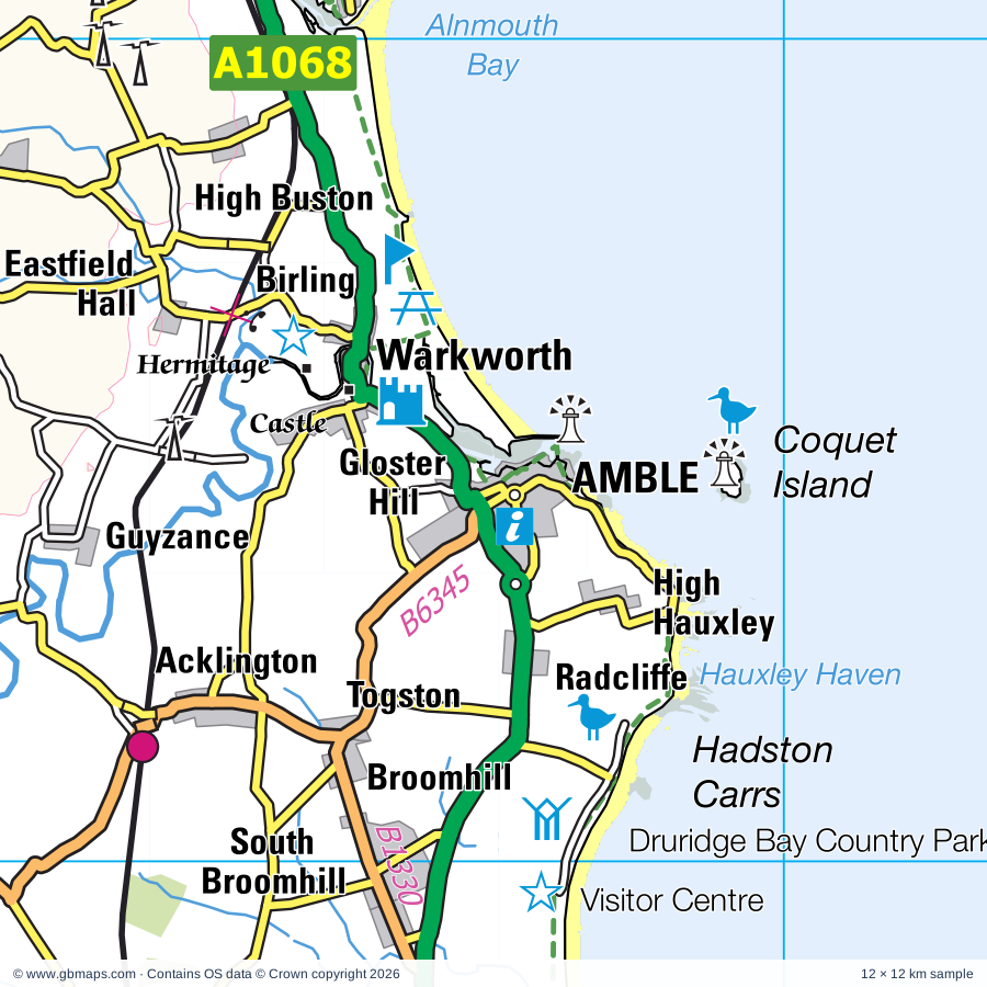
Amble regional road map. Full 60 × 60 km PDF, SVG and Illustrator files, with a free PDF sample.

GBMAPS.COM

Amble Regional Road Map

Call Us Now for Help01751 473136

GREAT BRITAIN ROAD ATLAS · 1:250,000 GB-420-0600

Amble & surrounding area

Explore the full 60 × 60 km Amble regional road map at 1:250,000, covering Amble, Morpeth, Rothbury, Ashington, Newbiggin-by-the-Sea. Compare the complete coverage below; a detailed PDF sample is available free.

AMBLE & SURROUNDING AREAREGIONAL ROAD MAP
60 × 60 km · Full map previewDownload the free SVG ↓

INSIDE THE FULL 60 × 60 KM MAP

Explore the Amble map area

1:250,000 cartography

Towns, villages & places

More mapped places (156)
  • Togston
  • Red Row
  • Stobswood
  • Widdrington
  • Longframlington
  • Radcliffe
  • Longhorsley
  • Tritlington
  • Warkworth
  • Fenrother
  • Ulgham
  • Shilbottle
  • High Buston
  • Hebron
  • Linton
  • Ellington
  • Bilton
  • Longhirst
  • Cresswell
  • Wingates
  • Alnmouth
  • Lesbury
  • Stanton
  • Edlingham
  • Pigdon
  • Pegswood
  • Lynemouth
  • Nunnykirk
  • Forestburn Gate
  • Bothal
  • Netherwitton
  • Whitton
  • Mitford
  • Denwick
  • Woodhorn
  • Abberwick
  • Throphill
  • Boulmer
  • Guide Post
  • Longhoughton
  • Hepscott
  • Stakeford
  • Tranwell
  • Bolton
  • Newtown
  • Littlehoughton
  • Choppington
  • Longwitton
  • Cartington
  • Clifton
  • Thropton
  • Callaly
  • Whittingham
  • Hartburn
  • Snitter
  • Meldon
  • Cambois
  • Nedderton
  • Howick
  • Stamford
  • Glanton
  • Rothley
  • Whalton
  • Saltwick
  • Rock
  • Flotterton
  • Middleton
  • Dunstan
  • Stannington
  • Craster
  • Eglingham
  • Hepple
  • Beanley
  • Ogle
  • Powburn
  • Harwood
  • Netherton
  • Branton
  • Cambo
  • Burradon
  • Embleton
  • Scrainwood
  • Alnham
  • North Charlton
  • Brandon
  • Belsay
  • Brownieside
  • Ingram
  • Holystone
  • Sharperton
  • Brunton
  • Old Bewick
  • Biddlestone
  • Knowesgate
  • Kirkwhelpington
  • Preston
  • Kirkharle
  • Capheaton
  • Wooperton
  • Ellingham
  • Milbourne
  • Seaton
  • Dinnington
  • Harbottle
  • Roddam
  • Chathill
  • Black Heddon
  • Seaton Sluice
  • Seghill
  • Dudley
  • Wallridge
  • Elsdon
  • Prestwick
  • Wideopen
  • Hazlerigg
  • Swinhoe
  • Newham
  • West Fleetham
  • Alwinton
  • Ilderton
  • Linhope
  • Kirkheaton
  • Heugh
  • Warenford
  • Dalton
  • Beadnell
  • Killingworth
  • Backworth
  • Newtown
  • Chillingham
  • Ingoe
  • Earsdon
  • Medburn
  • Stamfordham
  • Shiremoor
  • Fenwick
  • South Middleton
  • North Middleton
  • Ryal
  • Chatton
  • Thockrington
  • East Woodburn
  • Hallington
  • New York
  • Matfen
  • Ridsdale
  • Colwell
  • Bingfield
  • Humbleton
  • Akeld
  • Gunnerton
  • Chollerton
  • Barrasford
  • Humshaugh
  • Low Brunton
  • Walwick

Roads across this sheet

A68, A186, A188, A189, A190, A191, A192, A193, A196, A197, A696, A697, A1056, A1058, A1061, A1068, A1147, A1148, A1171, A1172, A6079, B1316, B1317, B1318

More road numbers

B1319, B1321, B1322, B1325, B1326, B1327, B1328, B1329, B1330, B1331, B1334, B1337, B1338, B1339, B1340, B1505, B1523, B6309, B6318, B6319, B6320, B6323, B6341, B6342, B6343, B6344, B6345, B6346, B6347, B6348, B6349, B6351, B6524, B6525, B6545, B6918

Rivers & waterways

College Burn, Fallowlees Burn, Harthope Burn, River Aln, River Alwin, River Blyth, River Breamish, River Coquet, River Font, River North Tyne, River Pont, River Rede

More waterways

River Till, River Wansbeck, Usway Burn, Wooler Water

Landmarks & landscape

Abbey, Aln Valley Railway, Alnwick Abbey, Alnwick Castle, Bailiffgate Museum, Fusiliers Museum of Northumberland, Barrow Mill, Beadnell Lime Kilns, Bedlington Country Park, Belsay Castle, Belsay Gardens, Belsay Hall, Bide-a-Wee Cottage Garden, NORTHUMBERLAND NATIONAL PARK

More named features

Big Waters Country Park Nature Reserve, Blue Reef Aquarium, Bolam Lake Country Park, Brinkburn Priory, CILVRNVM, Carrycoats Hall, Castle, Causey Park, Chesters Bridge Abutments, Chesters Bridge Abutments, Brunton Turret 26b, Childhood Memories Toy Museum, Chillingham Castle, Chillingham Castle and Gardens, Chillingham Wild Cattle Park, Coquet Island Nature Reserve, Cragside, Cragside Garden, Druridge Bay Country Park, Druridge Bay Nature Reserve, Dunstanburgh Castle, Edlingham Castle, Espley Hall, Fowberry Tower, Hall, Harbottle Castle, Haughton Castle, Hauxley Nature Reserve, Hermitage, Herterton House Gardens, House of Hardy, Howick Hall Gardens, Lady's Well, Lemmington Hall, Lime Kiln, Lorbottle Hall, Meldon Park, Morpeth Chantry Bagpipe Museum, Morpeth Clock Tower, Newcastle Racecourse, Newham Hall, Newton Pool Nature Reserve, North Charlton Rural Life Museum, Northumberland Cheese Farm, Northumberlandia Visitor Centre, Plessey Wood Visitor Centre, Plessey Woods Country Park, Preston Tower, Priory, QE2 Country Park, Seaton Delaval Hall, Shire Pottery, The Alnwick Garden, The Hall, Tosson Lime Kiln, Tosson Tower, Tower, Visitor Centre, Wallington, Wansbeck Riverside Park, Warkworth Castle, Warkworth Hermitage, Weetwood Hall, Whitehouse Farm Centre, Winter's Gibbet, Woodhorn Colliery Museum, Woodhouses Bastle
Local authority & parish coverage

Wholly or partly within the full map rectangle. These boundaries are coverage information, not additional artwork layers.

  • Newcastle upon Tyne DistrictPartly within
  • North Tyneside DistrictPartly within
  • NorthumberlandPartly within
Wards & electoral divisions 74 areas
  • Backworth & Holystone Ward (part)
  • Camperdown Ward
  • Castle Ward (part)
  • Cullercoats & Whitley Bay South Ward
  • Fawdon & West Gosforth Ward (part)
  • Forest Hall Ward (part)
  • Killingworth Ward
  • Kingston Park & Dinnington Ward (part)
  • Longbenton & Benton Ward (part)
  • Monkseaton Ward
  • New York & Murton Ward (part)
  • Newbiggin Hall & Callerton Ward (part)
  • Parklands & North Gosforth Ward (part)
  • Preston with Preston Grange Ward (part)
  • Shiremoor Ward (part)
  • St. Mary's Ward
  • Tynemouth Ward (part)
  • Weetslade Ward
  • Whitley Bay North Ward
  • Alnwick Castle ED
  • Alnwick Hotspur ED
  • Amble ED
  • Amble West with Warkworth ED
  • Ashington Central ED
  • Bamburgh ED (part)
  • Bebside & Kitty Brewster ED
  • Bedlington Central ED
  • Bedlington East ED
  • Bedlington West ED
  • Bellingham ED (part)
  • Bothal ED
  • Choppington & Hepscott ED
  • College with North Seaton ED
  • Corbridge ED (part)
  • Cowpen ED
  • Cramlington East & Double Row ED
  • Cramlington Eastfield ED
  • Cramlington North ED
  • Cramlington North West ED
  • Cramlington South East ED
  • Cramlington South West ED
  • Cramlington Village ED
  • Croft ED
  • Druridge Bay ED
  • Hartley ED
  • Haydon ED
  • Hirst ED
  • Holywell ED
  • Humshaugh ED (part)
  • Isabella ED
  • Longhirst ED
  • Longhorsley ED
  • Longhoughton ED
  • Lynemouth ED
  • Morpeth Kirkhill ED
  • Morpeth North ED
  • Morpeth Stobhill ED
  • Newbiggin-by-the-Sea ED
  • Newsham ED
  • Pegswood ED
  • Plessey ED
  • Ponteland East & Stannington ED (part)
  • Ponteland North ED
  • Ponteland South with Heddon ED (part)
  • Ponteland West ED (part)
  • Rothbury ED (part)
  • Seaton with Spital ED
  • Seghill with Seaton Delaval ED
  • Shilbottle ED
  • Sleekburn ED
  • South Blyth ED
  • Stakeford ED
  • Wensleydale ED
  • Wooler ED (part)
Civil parishes & communities 107 areas
  • Acklington CP
  • Adderstone with Lucker CP (part)
  • Akeld CP (part)
  • Alnham CP (part)
  • Alnmouth CP
  • Alnwick CP
  • Alwinton CP (part)
  • Amble By the Sea CP
  • Ashington CP
  • Bavington CP
  • Beadnell CP (part)
  • Belford CP (part)
  • Belsay CP
  • Bewick CP
  • Biddlestone CP (part)
  • Birtley CP (part)
  • Blyth CP
  • Brinkburn CP
  • Brunswick CP
  • Callaly CP
  • Capheaton CP
  • Chatton CP (part)
  • Chillingham CP
  • Chollerton CP (part)
  • Choppington CP
  • Corbridge CP (part)
  • Corsenside CP (part)
  • Cramlington CP
  • Craster CP
  • Cresswell CP
  • Denwick CP (DET)
  • Dinnington CP
  • Earle CP
  • East Bedlington CP
  • East Chevington CP
  • Edlingham CP
  • Eglingham CP
  • Ellingham CP (part)
  • Ellington and Linton CP
  • Elsdon CP (part)
  • Embleton CP
  • Felton CP
  • Glanton CP
  • Harbottle CP (part)
  • Hartburn CP
  • Hauxley CP
  • Hazlerigg CP
  • Hebron CP
  • Hedgeley CP
  • Hepple CP
  • Hepscott CP
  • Hesleyhurst CP
  • Hollinghill CP
  • Humshaugh CP (part)
  • Ilderton CP
  • Ingram CP
  • Kirknewton CP (part)
  • Kirkwhelpington CP
  • Lesbury CP
  • Lilburn CP
  • Longframlington CP
  • Longhirst CP
  • Longhorsley CP
  • Longhoughton CP
  • Lynemouth CP
  • Matfen CP (part)
  • Meldon CP
  • Mitford CP
  • Morpeth CP
  • Netherton CP
  • Netherwitton CP
  • Newbiggin by the Sea CP
  • Newton-by-the-Sea CP
  • Newton-on-the-Moor and Swarland CP
  • North Gosforth CP (part)
  • North Sunderland CP (part)
  • Nunnykirk CP
  • Otterburn CP (part)
  • Pegswood CP
  • Ponteland CP (part)
  • Rennington CP
  • Roddam CP
  • Rothbury CP
  • Rothley CP
  • Seaton Valley CP
  • Shilbottle CP
  • Snitter CP
  • Stamfordham CP (part)
  • Stannington CP
  • Thirston CP
  • Thropton CP
  • Togston CP
  • Tritlington and West Chevington CP
  • Ulgham CP
  • Wall CP (part)
  • Wallington Demesne CP
  • Warden CP (part)
  • Warkworth CP
  • West Bedlington CP
  • Whalton CP
  • Whittingham CP
  • Whittington CP (part)
  • Whitton and Tosson CP
  • Widdrington Station and Stobswood CP
  • Widdrington Village CP
  • Wooler CP (part)
  • Woolsington CP (part)

Source: the GBMaps road atlas, OS Boundary-Line and postcode mapping datasets. Source editions are being checked for publication. Unmarked boundary names are wholly within the sheet; “part” means the map edge crosses the area.

Place lists are selected from the map source, not a complete gazetteer. Named features describe the cartography; visitor facilities and opening status are not verified. The free sample covers only 12 × 12 km of this larger sheet.

INSIDE YOUR DOWNLOAD

A proper road map, in useful formats

Road classifications, towns and villages, railways, rivers, landscape detail and tourist symbols, brought together in the GBMaps regional road atlas style.

PDF filePDFSVG fileSVGAdobe Illustrator AI fileAi

PDF for the finished map. SVG and layered Illustrator artwork for adapting colours, adding your own information and preparing designs.

THE FINISHED SHEET

Designed for print and presentation

Map coverage
60 × 60 km
Sample coverage
12 × 12 km
Print layout
A3 landscape · enlarged 1:250k cartography
Sheet furniture
Border, scale bar, key & north arrow

A few useful details

What changes when I select another square?

Select a surrounding square to bring it into the centre and reveal the maps around it. Each square is a different 60 × 60 km map. The preview, free sample and selected download change together. Neighbouring sheets overlap by 30 km so you can choose the coverage that suits you.

Is the free sample a vector map?

The on-page detail is an SVG. The free download is a separate 12 × 12 km PDF with a link to the full map. Please retain its copyright credits and product link when sharing it.

Can I buy a larger combined map?

These downloads are individual ready-made sheets. Contact GBMaps if you need a larger combined area.

FREE PDF SAMPLE

Your free map sample

Your free 12 × 12 km sample includes a link back to this map, so you can return for the full area whenever you need it.

Download free PDF sample ↓

Get your Amble map

Map download bundle

£24.00including VATOne payment

Pay securely

One payment. Your map stays open.

Your map download

Your map files

Preparing your download…

Checking your private download link…

Your map downloads

Already bought a map?

Find the downloads from your purchases.

Enter the email address you used at checkout. We’ll email you a private link to your available map downloads.