Aberfeldy regional road map. Full 60 × 60 km PDF, SVG and Illustrator files, with a free PDF sample.

GBMAPS.COM

Aberfeldy Regional Road Map

Call Us Now for Help01751 473136

GREAT BRITAIN ROAD ATLAS · 1:250,000 GB-270-0750

Aberfeldy & surrounding area

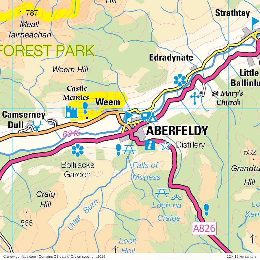
Explore the full 60 × 60 km Aberfeldy regional road map at 1:250,000, covering Aberfeldy, Pitlochry, Crieff, Invervar, Fortingall. Compare the complete coverage below; a detailed PDF sample is available free.

ABERFELDY & SURROUNDING AREAREGIONAL ROAD MAP
60 × 60 km · Full map previewDownload the free SVG ↓

INSIDE THE FULL 60 × 60 KM MAP

Explore the Aberfeldy map area

1:250,000 cartography

Towns, villages & places

  • Aberfeldy
  • Pitlochry
  • Crieff
  • Invervar
  • Fortingall
  • Fearnan
  • Keltneyburn
  • Camusvrachan
  • Acharn
  • Kenmore
  • Dunalastair
  • Lawers
  • Dull
  • Ardtalnaig
  • Carie
  • Innerwick
  • Foss
  • Camserney
More mapped places (43)
  • Ardeonaig
  • Weem
  • Trinafour
  • Kiltyrie
  • Killichonan
  • Struan
  • Calvine
  • Auchnafree
  • Bridge of Gaur
  • Killin
  • Strathtay
  • Grandtully
  • Blair Atholl
  • Invergeldie
  • Amulree
  • Aldclune
  • Balnaguard
  • Milton
  • Killiecrankie
  • Pubil
  • St Fillans
  • Logierait
  • Milton of Edradour
  • Ardchyle
  • Auchlyne
  • Ballinluig
  • Balmacneil
  • Lochearnhead
  • Comrie
  • Dalguise
  • Kindallachan
  • Trochry
  • Quoig
  • Hosh
  • Monzie
  • Gilmerton
  • Auchtubh
  • Balquhidder
  • Harrietfield
  • Keillour
  • Madderty
  • St David's
  • Balgowan

Roads across this sheet

A822, A826, A827, A924, B827, B846, B847, B898, B8019, B8062, B8063, B8079

Rivers & waterways

Abhainn Duibhe, Abhainn Ghuilbinn, Allt Bail a' Mhuilinn, Allt Cam, Allt Camghouran, Allt Con, Allt Conait, Allt Eigheach, Allt Feith Thuill, Allt Garbh Buidhe, Allt Ghlas, Allt Glas Choire

More waterways

Allt Gleann Da-Eig, Allt Glen Loch, Allt Mor, Allt Riobain, Allt Ruighe nan Saorach, Allt Shallainn, Allt Sleibh, Allt Strath a' Ghlinne, Allt a' Chaoil-reidhe, Allt a' Chireachain, Allt a' Mhuilinn, Allt na Bogair, Allt na Glaise, Aqueduct, Auchlyne West Burn, Aulich Burn, Ballinloan Burn, Balnaguard Burn, Beich Burn, Black Water, Bruar Water, Calair Burn, Cowgask Burn, Dall Burn, Eas Daimh, Edendon Water, Errochty Water, Fender Burn, Finglen Burn, Garbh Ghaoir, Innerhadden Burn, Invergeldie Burn, Keltney Burn, Killichonan Burn, Lawers Burn, Milton Burn, Pow Water, River Almond, River Ardle, River Balvag, River Braan, River Cononish, River Dochart, River Earn, River Ericht, River Garry, River Gaur, River Lednock, River Lochay, River Lyon, River Ossian, River Pattack, River Quaich, River Tay, River Tilt, River Truim, River Tummel, Shaggie Burn, Shochie Burn, Tarf Water, Tombane Burn, Uisge Labhair, Urlar Burn, Water of Ruchill
Landmarks & landscape

Aberfeldy Watermill, Aberfeldy Distillery, Abernethy Trust, Atholl Country Collection, Atholl Palace Hotel, Ben Alder Lodge, Ben Lawers Nature Reserve, Blair Atholl Distillery, Blair Atholl Watermill, Blair Castle, Bolfracks Garden, Bonskeid House, Bruar Lodge, CAIRNGORMS NATIONAL PARK, LOCH LOMOND & THE TROSSACHS NATIONAL PARK, TAY FOREST PARK

More named features

Caithness Glass, Castle Menzies, Chesthill Estate Activity Centre, Clan Donnachaidh Museum, Cluny House, College, Corrievarkie Lodge, Corrour Shooting Lodge, Craiganour Lodge, Crieff Visitor Centre, Strathearn Pottery, Cross, Dall, Dalnacardoch Lodge, Dalnaspidal Lodge, Deil's Caldron, Drummond Hill Cycle Routes, Dundurn, Dunfallandy Stone, Edradour Distillery, Edradour Distillery, Blair Atholl Distillery, Visitor Centre, Falls of Acharn, Falls of Bruar, Falls of Dochart, Forest Lodge, Fortingall Yew Tree, Fowlis Wester, Glengoulandie Country Park, Glenlyon Gallery, Glenlyon House, Glenturret Distillery, Hercules Garden, Highland Adventure Safaries Visitor Centre, Hotel, Killiecrankie Visitor Centre, Soldier's Leap, Linn of Tummel, Lochdochart House, Logiealmond Lodge, Meggernie Castle, Moirlanich Longhouse, Monzie Castle, Moulin Brewery, Pitlochry & Moulin Heritage Centre, Pitlochry Dam Fish Ladder, Festival Theatre, Pitlochry Power Station Visitor Centre, Heathergems Visitor Centre, Power Station, Queen's View Visitor Centre, Rob Roy's Grave, Scottish Plant Collectors Garden, Scottish Quads, Sronphadruig Lodge, St Mary's Church, Stone, Taymouth Castle, The Scottish Crannog Centre, Tomphubil Limekiln, Tummel Bridge Cycle Routes

Local authority & parish coverage

Wholly or partly within the full map rectangle. These boundaries are coverage information, not additional artwork layers.

  • Argyll and ButePartly within
  • HighlandPartly within
  • Perth and KinrossPartly within
  • StirlingPartly within
Wards & electoral divisions 10 areas
  • Almond and Earn Ward (part)
  • Badenoch and Strathspey Ward (part)
  • Blairgowrie and Glens Ward (part)
  • Caol and Mallaig Ward (part)
  • Fort William and Ardnamurchan Ward (part)
  • Highland Ward (part)
  • Oban North and Lorn Ward (part)
  • Strathearn Ward (part)
  • Strathtay Ward (part)
  • Trossachs and Teith Ward (part)
Civil parishes & communities 0 areas

    Source: the GBMaps road atlas, OS Boundary-Line and postcode mapping datasets. Source editions are being checked for publication. Unmarked boundary names are wholly within the sheet; “part” means the map edge crosses the area.

    Place lists are selected from the map source, not a complete gazetteer. Named features describe the cartography; visitor facilities and opening status are not verified. The free sample covers only 12 × 12 km of this larger sheet.

    INSIDE YOUR DOWNLOAD

    A proper road map, in useful formats

    Road classifications, towns and villages, railways, rivers, landscape detail and tourist symbols, brought together in the GBMaps regional road atlas style.

    PDF filePDFSVG fileSVGAdobe Illustrator AI fileAi

    PDF for the finished map. SVG and layered Illustrator artwork for adapting colours, adding your own information and preparing designs.

    THE FINISHED SHEET

    Designed for print and presentation

    Map coverage
    60 × 60 km
    Sample coverage
    12 × 12 km
    Print layout
    A3 landscape · enlarged 1:250k cartography
    Sheet furniture
    Border, scale bar, key & north arrow

    A few useful details

    What changes when I select another square?

    Select a surrounding square to bring it into the centre and reveal the maps around it. Each square is a different 60 × 60 km map. The preview, free sample and selected download change together. Neighbouring sheets overlap by 30 km so you can choose the coverage that suits you.

    Is the free sample a vector map?

    The on-page detail is an SVG. The free download is a separate 12 × 12 km PDF with a link to the full map. Please retain its copyright credits and product link when sharing it.

    Can I buy a larger combined map?

    These downloads are individual ready-made sheets. Contact GBMaps if you need a larger combined area.

    FREE PDF SAMPLE

    Your free map sample

    Your free 12 × 12 km sample includes a link back to this map, so you can return for the full area whenever you need it.

    Download free PDF sample ↓

    Get your Aberfeldy map

    Map download bundle

    £24.00including VATOne payment

    Pay securely

    One payment. Your map stays open.

    Your map download

    Your map files

    Preparing your download…

    Checking your private download link…

    Your map downloads

    Already bought a map?

    Find the downloads from your purchases.

    Enter the email address you used at checkout. We’ll email you a private link to your available map downloads.