


 Circles
Loading your map...




Add a shape or note, draw your own boundary, or highlight a map area.
Available to try before you buy.
 Shapes & Text
Drag a shape to move it; drag the map to pan. Scroll to zoom. Space + drag pans over a shape. Done returns to colouring.
Turning on copies this set's sizes, colours and labels to all sets.
Click the map to set the centre.
Add a logo, photograph or illustration. Keep each image on the page, or let it move with the map.
 Drop your images herePNG, JPEG or WebP · up to 3 MB each
Up to five images. Try it before you buy.
Drag the image to move it. Drag a corner to resize; hold Shift to keep its proportions. Scroll over the map to zoom.
 Your markers
Add a marker to get started.
Tick, then click the map to position it.
 Appearance
 Paste your data
Paste matching columns from Excel.
No rows yet
One postcode per row. Leave zone names blank to use Zone 1.
ColoursUse your own colour column.
 Sample data
Selecting a sample imports it to the map.

Paste matching columns from Excel. Keep each postcode, zone and colour on the same row.
 Selecting a sample imports it.
No rows yet
Click a name to copy it. Leave Colours blank for automatic colours.
No matching colours. Try another name.
Paste a separate table: Zone name, Line 1, Line 2, Line 3… Use one row per zone named above. Existing details are kept when cells are blank.
A contact postcode here is just text. Use the Postcodes column above to colour areas.
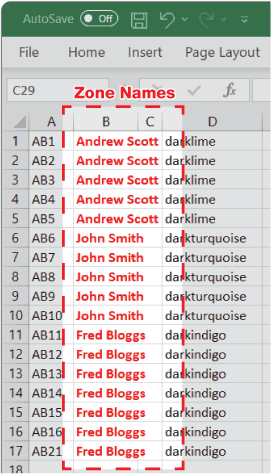
Copy one column at a time, without its heading, and paste it into the matching box above. Use one row per postcode. Repeat the zone name and colour for postcodes in the same zone.


Colour map areas by their values. See where sales are strongest, or compare your figures at a glance.
Only use percentages already calculated for these map areas. Adding percentages from smaller areas does not give a valid total.
Previewing these ranges leaves your map alone. Creating the heat map changes its territory colours; Undo restores them.
Add your sales, customers or other figures. Colour territories as usual and see their totals in the legend.
 Load included statistics
Use the arrows to set the order in the legend.
Search both mapping tools

Choose a CSV file or paste columns from Excel. Keep each postcode and its settings on the same row.
One setting on its own applies to every postcode. Blank settings use the examples below. Up to 500 rows.
No rows yet
Use full UK postcodes. Shapes: circle, square, triangle, hexagon, star. Label positions: top, bottom, left, right, middle. Radius is in miles; a label size of 0 hides its text. Colours can be names such as red or hex values such as #E8AC25.
Paste columns without headings, or paste a whole Excel table into the Postcodes box. CSV files may include a heading row. Multi-line cells are joined with spaces.

Choose a CSV file or paste columns from Excel. Keep each postcode and its settings on the same row.
One setting on its own applies to every postcode. Blank settings use the examples below. Up to 500 rows.
No rows yet
Use full UK postcodes. Position each box above or below its postcode, with a line or arrow. A callout length of 0 hides the line. Colours can be names, palette names such as teal400, or hex values such as #E8AC25. London inset: auto detects London postcodes; true uses the inset and false uses the main map.
Paste columns without headings, or paste a whole Excel table into the Postcodes box. CSV files may include a heading row. Multi-line cells are joined with spaces.

Choose a CSV file or paste into the columns below. Each row is one centre and its set of distance rings.
Give every row its own ID, postcode, circle count, interval, line width and label size. Keep the columns aligned.
No circle sets yet
Use a unique Set ID made from letters, numbers, underscores or hyphens, and a full UK postcode for each centre. Number, interval, line width and label size must be whole numbers in the ranges shown. The outer radius is the number of circles multiplied by the interval.
In Ring labels and Ring colours, separate the individual rings with commas, from the innermost to the outermost. Put a label containing a comma in double quotes. Use red, blue, green, yellow or black for the colours. Blank labels are allowed; a blank colour leaves that ring’s outline hidden.
The CSV uses separate ring_label_1, ring_colour_1 and subsequent ring columns, as shown in the sample. Unlike dots and markers, one value in a column does not apply to every row.
Tell me what you want to make.
Ask in your own words. I can make changes to your map, or show you how. Check my short plan, then let me do the work.
We keep questions and replies for up to 90 days to improve GBMaps. During launch, questions may also be emailed to GBMaps support. Please leave out confidential information.

Print View

Design

On Google
Loading your map...


